Saguaro Grove Picture of the Week

When I was roaming around Black Canyon City a couple of weeks ago, I was on a street with homes along the right side and open land on the other. On the hillside was a dense stand of saguaro growing, and I knew I wanted to capture their image, but the field had a barbed wire fence. As I drove further down the street, I found an open spot. A gravel road led onto the property, so I parked the truck and got out for a closer look.

Saguaro Grove
Saguaro Grove – these giant cacti grow exceptionally well on south-facing, well-drained slopes.

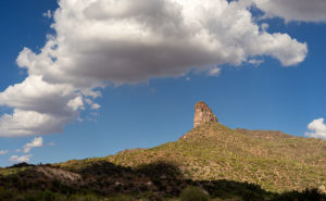
I’m usually cautious about trespassing, so I always look for Keep Out signs. After all, this is Arizona, and I’m allergic to bullets. I saw no postings nearby, but a sign was down the road. It read, “Agua Fria National Monument.” I thought, “There’s a national monument? Here, this close to Phoenix? Why don’t I know about this?” All the open areas from Black Canyon City to Cordes Lakes and east of Interstate 17 were given monument status in 2000 because the Agua Fria River is a treasure of ancient dwellings, petroglyphs, and artifacts. There are no freeway signs, visitor centers, or entrance fees. There is a hiking trail that runs its length, and you can walk, bike, or ride horseback. Bloody Basin Road cuts through the monument; from it, you can access a couple of rugged jeep trails. So, I’ve already mentally filed it away as a future project.

Meanwhile, back at Black Canyon City …

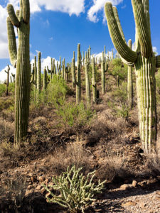
Saguaro grows exceptionally well on well-drained south-facing slopes, so when you see a grove like this, you can tell the compass direction—like moss on the north side of trees. The overhead clouds are remnants of Hurricane Rosa, which dumped enough rain to plump up these giant cacti. They look like my uncle making his way to the couch after Thanksgiving dinner. I could have titled the image with a snarky name, but I didn’t. It’s merely titled Saguaro Grove.

You can see a larger version of Saguaro Grove on its Web Page by clicking here. I hope you enjoy viewing this week’s post and return next week when we show another featured image from Black Canyon City.

Until next time — jw

Perry Mesa Needle Picture of the Week

Perry Mesa Needle
Perry Mesa Needle – This needle is at the edge of Perry Mesa above Black Canyon City. It’s new to me because it’s hidden from the freeway.

Phoenix only has two interstates that will get you the hell out of Dodge; Interstate 10 which either takes you west to California or east to everywhere else, and Interstate 17 going north. Driving I-10 in either direction always seems like a dreary, endless drive through the desert, while I associate I-17 with good times, like playing in the snow or—during summer—just escaping the heat. I think it’s because of all the different climate zones it goes through, like the desert, grasslands, riparian, and alpine forests.

The first change that you come to when heading north is the grade at Black Canyon City. It’s an abrupt transition from the Sonoran Desert to riparian grassland—saguaros are at the bottom, and they’re not at the top. It freezes more often at higher elevations, and the giant cacti can’t tolerate it. Black Canyon City is distinguished by being the northern edge of the Sonoran Desert; I know that because it says so on their welcome sign.

Most Phoenicians consider Black Canyon City a suburb populated with free-spirited residents. It’s the bottleneck on the highway where heavily ladened trucks insist on passing one another up the steep grade, or traffic is backed up to Prescott because a crash closed the freeway and there’s no other way around. During heavy rain, the community makes the news because the Agua Fria River floods and people get trapped in their homes or cars. If you do stop in town, it’s to get a slice of pie at its famous restaurant. I wouldn’t be surprised if most Phoenicians didn’t know Black Canyon was in a different county—Yavapai. I know that I didn’t, and that’s why I chose Black Canyon City as my place to look for October’s art.

I saw the subject of this week’s photo as I was driving around town. I-17 divides Black Canyon City in two. The business district is on the freeway’s west side while on the east is mostly residential and a few light industries. The needle can be seen on the east side but not from the interstate. That’s why I didn’t know it was there. It’s like a smaller version of Weaver’s Needle in the Superstitions, but as much as I searched, I couldn’t find its name. There was nothing on my topographic maps, highway maps, the Gazetteer or the city’s website. I saw this neat YouTube drone video, but it doesn’t list a name either. It’s on the southwest corner of Perry Mesa (sounds like an excellent name for a lawyer, doesn’t it?) where Squaw Creek runs into the Agua Fria River, so I used that moniker for the photo’s name—Perry Mesa Needle.

In this image, I like the way the low clouds and their shadow frame the subject. The grove of saguaro midway up adds scale to the outcrop. Finally, the recent rains cleared the air and gave me a deep blue sky making the puffy white clouds seem to pop in 3D. As was the case with the Jerome Hollyhocks a couple of months ago, if you know this needle’s name, please email me.

You can see a larger version of Perry Mesa Needle on its Web Page by clicking here. I hope you enjoy viewing this week’s post and come back next week when we’ll feature more from Black Canyon City.

Until next time — jw

Vortex Picture of the Week

Have you ever been to a place, but you didn’t know you were there until you went away? I know that sounds like a Yogi Berra-ism, but it will make perfect sense once I explain. Most of the time when I’m out shooting, I have to come back to the office and scour maps to name the landmarks that are in my pictures—and you thought I was a human geography book. That’s the story behind this week’s featured image that I call Vortex.

Vortex
Vortex-I was able to compose two photographs standing on the Boynton Pass Overlook. I found out later that it’s also the location of one of the four Sedona vortexes.

For Sedona month, I wanted to get images of the red rocks that aren’t on every calendar that you’ve owned, so I scouted and explored a couple of trails that were off the beaten path. One of them was the Boynton Pass Overlook Trail, and I took the Climbers photo featured three weeks ago from the same place. Back at the office, I searched Google Maps to see if the pinnacle they were scaling had a name. It didn’t (Wrong. According to the site in the following link, its name is Kachina Woman – jw), but—according to the map—I was standing on (or near) the Boynton Pass Vortex. When it comes to those kinds of metaphysical things, I must admit that I’m a skeptic, so I wasn’t searching for a vortex. I was after the view. It’s interesting that there isn’t a marker to show it’s there and I didn’t come away enlightened. I did, however, get two photos from one spot, so maybe …

This smaller turret and the much taller tower as seen in Climbers flank each end of the overlook saddle. Since they’re on opposite ends, if you look at one, you have to turn around to see the other. I liked the shape of this little guy—it kind of looks like an inverted tornado. I don’t know what a vortex looks like, so maybe this is one.

Another thing that appeals to me is the plants. Within the frame, are all the varietals that make up the Sedona chaparral: juniper, sage, prickly pear, agave, and some others that I can’t identify by name. I’d like to think that this shot is a miniature Sedona model—a stack of red sandstone and the plants thriving there. If I had a stag deer majestically posing in the photo, it would have been perfect—or maybe have it spinning through the air like the cows in the movie Twister.

You can see a larger version of Vortex on its Web Page by clicking here. I hope you enjoy viewing this week’s post and come back next week when we’ll start another month in a new site.

Until next time — jw

North Side Capitol Butte Picture of the Week

Seeing a photograph isn’t predictable. Sometimes you find a subject and wait for the light to be right as I did for the image Capitol Butte from a couple of weeks ago. Ansel Adams was notoriously patient about doing this. Sometimes he’d wait hours or days for the light to come in. Sometimes you see an image as you’re walking a trail and you drop to your knees to capture it. That’s what happened when I shot last week’s featured image Prickly Juniper. Sometimes a subject will show up through the car window and you’ll have to jump out of the car and grab it. That’s the story behind Ansel Adam’s masterpiece Moonrise over Hernandez. He saw the image forming through the windshield, stopped his car to set-up his view camera and had to calculate the exposure without a light meter. I’m not comparing the two photographs, but that’s also the story of this week’s featured image that I call North Side Capitol Butte—except for the light meter part.

North Side Capitol Butte
North Side Capitol Butte – A late afternoon sun adds a glow to Capitol Butte in Sedona, Arizona

I was driving into town from the hiking trail and I was paying attention at the light on Capitol Butte. While I was driving, I saw the butte framed between two trees, so I stopped the car and got out and moved in for the kill. This framing technique was very popular in the Hudson River School style of painting. The center subject is lit between two darker shapes to keep your eye from wandering off the canvas. The technique fell out of favor as the Impressionist began to gain popularity. Just because something’s no longer popular, there isn’t any reason you can’t drag it out of the closet now and then.

You can see a larger version of North Side Capitol Butte on its Web Page by clicking here. I hope you enjoy viewing this week’s post and come back next week when we’ll present the last image from Sedona Month.

Until next time — jw

Prickly Juniper Picture of the Week

In a place like Sedona, with its canyons and red-rock buttes, it’s easy to get overwhelmed by abundant beauty. I can imagine a project where I simply recorded a catalog of the natural formations along Oak Creek, but that would make for a boring story. A good story changes pace and adds contrast. That’s why, as I scurry about hither and yon at a new site, I keep my eyes open for interesting things below my nose.

Prickly Juniper
Prickly Juniper – A prickly pear cactus grows in the sun beneath a dead juniper tree in Sedona Arizona.

This week’s featured image—called Prickly Juniper—is an example of looking for intimate subjects amidst spectacular scenery. I saw this prickly pear along the trail that I wrote about last week. If it were on its own, I probably would have ignored it, but it nestled under the bare branches of a dead juniper tree and together they caught my attention. I liked the light against the dark, the living against the dead, and the prickly pear’s circular pads against the tree’s linear branches. The late afternoon sun was showing off the tree’s texture and the cactus’ lethal thorns. I took a couple of variations of this image and I felt this version was the best.

You can see a larger version of Prickly Juniper on its Web Page by clicking here. I hope you enjoy viewing this week’s post and come back next week when we’ll present another featured image from Sedona.

Until next time — jw