Aquarius Boulders Picture of the Week - Wikiup, Arizona

Long before Arizona was a state, it belonged to another country—Mexico. In retaliation to the Alamo massacre, the U.S. declared war on our southern neighbor and took away half of their land. When Mexico surrendered, we tossed fifteen million dollars (the same amount as the Louisiana Purchase) on the bed and said, “The money’s for the room, babe.” Our newest land acquisition was called New Mexico Territory, but—because it was so vast—we split it into several states. Arizona was the last to make the team.

To see what their money got, cigar-chomping Washington politicians handed some change to a young lieutenant—Amiel Weeks Whipple—then told him, “Here, kid. Grab a couple of guys, a tape measure, and measure the backyard.” This expedition was Lt. Whipple’s first across our state. He started in San Diego and headed east, surveying land along the new border. His second journey was in the other direction, and this time, he was to lay out a railroad route along the 35th Parallel—Interstate 40.

I mention Lt. Whipple because, when I research how an Arizona location got its name, it is often cited in Arizona Place Names—that’s the reference I usually use. As he worked his way across the territory, surveying, mapping, and fighting Apaches, Whipple didn’t have the luxury of stopping someone to ask, “Excuse me, but what do you call those mountains?” Not many people lived here, and many who did were cranky. After all, air conditioning hadn’t been invented yet. Instead, if a place needed a name, he’d make something up that seemed to fit.

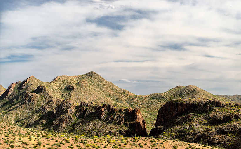
That’s precisely how the Aquarius Mountains got their name. Whipple, who found abundant water sources in the range, named them after the mythological water bearer. If you’ve driven to Kingman, you’ve passed by the Aquarius Range. They are on the east side of U.S. Highway 93 from Wikiup north to almost Interstate 40. The highest peak is Snow Mountain, with an elevation of 5880′, so it sometimes has snow. Several dirt roads go up into the range, which will be the routes we’ll scout for exciting photographs. We will be spending the month of July photographing along the Aquarius’s back roads.

The first road I’ve always wanted to follow has perplexed me since I drove U.S. 93—Upper Trout Creek Road. Give me a break; this is the Upper Sonoran Desert (the transition zone); how can a creek be cold enough to support trout? It doesn’t, or at least not this particular Trout Creek. This one is a tributary of the Big Sandy River. As soon as the road crosses the Big Sandy, it’s called something else according to Archie’s navigation system (but not on the Gazetteer). I drove the road to the ridge, where I was treated to a beautiful vista to the east.

Aquarius Boulders
Aquarius Boulders—The rocks, trees, and sky are bathed in a warm glow as the sun sets over the Hualapai.

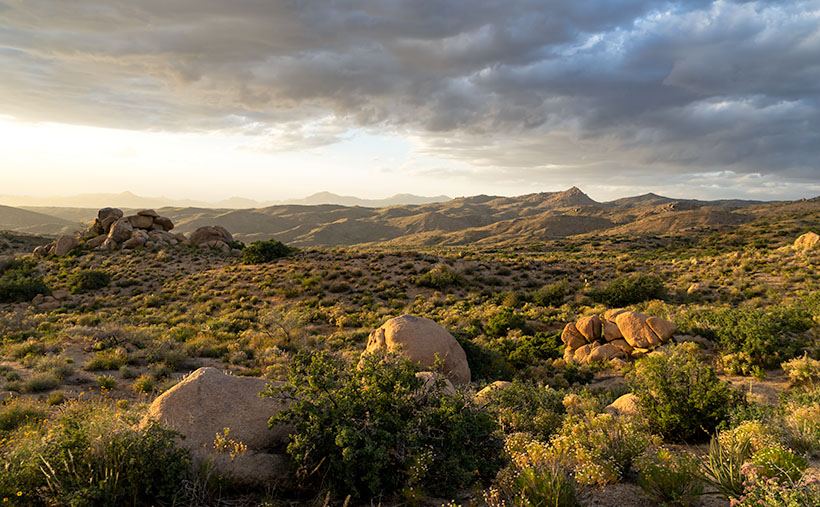
This week’s image is from Granite Flat, halfway up the mountainside. When I stopped, the sun was going down behind the Hualapai Range (on the west side of Highway 93), and its rays cast a warm glow on the rocks, peaks, and low clouds hovering in the sky. I call this shot Aquarius Boulders. It’s a scene looking north with Hwy 93 in the valley to the left and the Aquarius peaks to the right.

You can see a larger version of Aquarius Boulders on its Web Page by clicking here. Be sure to return next week when we set off for another adventure exploring Arizona’s back roads.

Until next time — jw

Mine Tailings Picture of the Week

With this posting, we’ve completed this month’s photo excursion of Castle Hot Springs Road. The detour north of State Route 74 started with almost prairie-like flat desert adjacent to the Wickenburg range. Then the road ascended into the Buckhorn Range with a magnificent view of the Bradshaw’s. Next, our back road dropped down to Castle Creek through the Hieroglyphic Mountains past the hot springs resort. Finally, we returned to asphalt at Lake Pleasant where we saw vast groves of saguaros growing on the mountain slopes (I put that in my mental filing cabinet for a future outing).

There was one scene along the way that wasn’t quite ripe enough to shoot when I first drove by it, so I wanted to backtrack and see if it improved with the warm afternoon sun. It did, and it is this week’s featured image which I call Mine Tailings.

Mine Tailings - Tailings comprised of red soil caught my eye because of the color and erosion pattern.
Mine Tailings – Tailings comprised of red soil caught my eye because of the color and erosion pattern.

I don’t know if there are an inordinate number of mines in Yavapai County, but it seems like they’re everywhere. A few hearty souls—that either suffer from unrelenting gold fever or have nothing better to do—still work the claims, but most of the mines are abandoned. When the ore runs dry, the prospectors move on in search of the next elusive bonanza. Because there’s no economic incentive to restore the claim, abandoned mines are left unposted and are often dangerous. Just this year, rescuers have pulled a couple of people trapped in mine shafts. It’s a growing Arizona problem.

One of the tells of an old mine is the tailings. As prospectors tunnel into a mountainside, they have to remove the diggings and pile them somewhere. In massive operations, fleets of trucks build hundred-foot-tall dikes, like the one that used to line Highway 60 in Miami, Arizona. But with smaller claims of one or two men, they will fill a wheelbarrow and walk it outside and dump it over the edge, building a tailings dump; the deeper the mine, the bigger the tailings.

The thing that makes the tailings in this week’s photo interesting to me is that they’re red, and the late afternoon sun exaggerates that color. The red against the blue sky vibrates my eyeballs. There’s more that we can learn from the image, like how old it is. The erosion patterns are deep from many seasons of heavy rain, and its fan pattern is reminiscent of what you see in the Painted Desert. In both cases, water easily cut through soft soil. Finally, dirt and rock that comes out of a shaft is well below the topsoil level, so it’s not rich in nutrients. Here, the desert Mesquite has begun to colonize the hillside, so the soil contains some organic material already.

You can see a larger version of Mine Tailings on its Web Page by clicking here. Be sure to come back next week when we set off for another adventure exploring Arizona’s back roads.

Until next time — jw

Salvation Peak Flag Picture of the Week

Castel Hot Springs Resort
Castle Hot Springs Resort—Originally built in 1896 by Frank Murphy, the owner of the Congress Mine, it will reopen in October, so cash in your IRA and visit. I believe the tarp covers the garden where the chief grows fresh vegetables for the restaurant.

It doesn’t matter which way you travel on Castle Hot Springs Road, either clockwise or the other way, will get you to the historic retreat—the luxury resort for the rich and famous built-in 1896. Your choice of travel depends on whether you want to drive through the mountains via Morristown or north of Lake Pleasant via Castle Creek. As a history buff, I prefer the original route, but I also live closer to the old railroad depot, and I’m too lazy to drive that distance to Lake Pleasant.

After moving to Arizona, I heard stories of the ghost resort from friends, but I didn’t look at it for thirty years. After the last of my infamous station wagons was totaled while parked in the Sun City Boswell Hospital parking lot, we replaced it with my first SUV—Shadowfax. It was an Olds Bravada with ground clearance and four-wheel drive that was good enough to begin exploring back roads. One of my first outings was to Castle Hot Springs. As a film shooter back then, I didn’t have a perfect shot of the main house, so I didn’t bother taking any pictures.

There’s quite a bit of history that would make good stand-alone stories. Trivia like:

  • The hot spring was found by Ft. Whipple Calvary soldiers tracking bandits.
  • Frank Murphy—the Congress Mine owner—bought the land, built the buildings, and paid for the road.
  • The resort thrived during the first half of the 20th Century, catering to the Roosevelts, Rockefellers, Vanderbilts, Wrigleys, Zane Gray, and Clark Gable (there had to be famous actresses who visited, too, but I didn’t discover any of their names).
  • Murphy’s brother, when he was the territorial governor, turned the resort into Arizona’s Mar-A-Lago because winters were too cold in Prescott. And because Warren Murphy ran the state from here, Arizona’s first telephone was installed in the hall of the main building (I believe it survived the ’76 fire).
  • The temperature of the hot springs water is 12oº, which is the same as every Phoenix household during summer.

There’s another more interesting story, however. The resort was dark during the Second World War because of rationing and shortages. After the war ended, Walter Rounsevel, owner and general manager, leased the property to the U.S. military as a recovery and rehab facility for injured officers. One of those officers was a young lieutenant whose back was injured after a Japanese destroyer rammed his PT boat. The officer’s name was John F. Kennedy, and he spent several months recovering at Castle Hot Springs, soaking in the springs, hiking trails, and golfing.

Salvation Peak Flag - For providing a place for injured servicemen to recuperate during World War II, the Castle Hot Springs Resort got special dispensation to fly an American Flag on Salvation Peak 24 hours a day.
Salvation Peak Flag—During World War II, the Castle Hot Springs Resort received special dispensation to fly an American Flag on Salvation Peak 24 hours a day to provide a place for injured officers to recuperate.

For its part in helping with the recovery of these servicemen, a special dispensation was given to Castle Hot Springs to fly an American flag 24 hours a day atop Salvation Peak. The flag was visible along the road before and after passing the resort, and I took several shots of it even though the sun was directly behind. My favorite version is this week’s featured image, which I call Salvation Peak Flag. Although it looks formidable, Salvation Peak is a smaller outcrop of Governors Peak, which is located within the Hells Gate Wilderness area.

You can see a larger version of Salvation Peak Flag on its Web Page by clicking here. Be sure to return next week when we present the final photo I made on my Castle Hot Spring Road outing.

Until next time — jw

Big Hell’s Gate Picture of the Week

Castle Hot Springs Road’s loop north of Arizona State Route 74 passes three small desert mountain ranges. Driving the road from west to east, first, we skirt the Wickenburg Range, which you can see out of the driver-side window. Shortly after that, the highway began to weave through the Buckhorn Range and past the picture stops, about which I wrote the last two weeks. Just around the bend from the AD Wash Gap, our back road climbs a sharp grade to a ridgeline—the highest point along our journey. There are great views once we reach the top, so a photography stop is imperative.

It was hard to decide where to look when I got out of the truck because there was so much to see. To the north are Castle Creek Basin, Sheep Mountains, and the Bradshaw’s on the distant horizon. This was the only image I took and brought home on my first visit. Of course, I shot with film then and was stingy about wasting it.

View From The Ridge–you can see the Sheep and Bradshaw Mountains in the north from the high point along the Castle Hot Springs Road.

If you turn around and face south, however, you have a great view of Hells Canyon Wilderness and our third range of mountains—the Hieroglyphic Mountains. The Castle Hot Springs Road encircles the wilderness and even passes through a corner along its eastern flank. From this viewpoint, you can see into it and feel like you could reach out and touch it; you can’t get there from here (thanks again, Yogi). Because the wilderness area abuts private property on its north and east sides, you have to hike in on trails from the south or west. Here, there are signs clearly stating, “No Trespassing. No Hunting. No Hiking. Don’t even think about it.”

Big Hell's Gate--An excelent view into the Hell's Canyon Wilderness area with Big Hell's Gate in front of Hellgate Mountain.
Big Hell’s Gate–An excellent view into the Hell’s Canyon Wilderness area with Big Hell’s Gate posing in front of Hellgate Mountain.

I took this week’s picture from this ridge, about halfway back down the hill, to avoid telephone lines. There are several 3000′ peaks in Hells Canyon Wilderness, Governor’s Peak, Garfias Mountain, and the one seen here—Hellgate Mountain. They surround a Burro Flat basin that provides solitude isolated from metropolitan Phoenix.

The gap in the basalt ridge is Big Hell’s Gate, which is the same Bitter Creek ground away we drove through two weeks ago. The creek flows through the gap, then off to the left, gouging another slot called Little Hells Gate. I’ve not been fortunate enough to have seen or photographed it, but maybe someday. As they say in car racing, “As long as there’s movement, there’s hope.

Click here to see a larger version of Big Hells Gate on its Web Page. Be sure to return next week when we see another beautiful stop I made on my Castle Hot Spring Road outing.

Until next time — jw

AD Wash Gap Picture of the Week

This month’s photo topic is Castle Hot Springs Road—part of my long-term project of getting off the highways to explore Arizona’s back roads. My only restriction is that the roads are accessible by regular passenger cars. That’s because I don’t want to buy some dune buggy for the project (Actual Read: Queen Anne won’t let me buy one).

Since I live on its west, Castle Hot Springs Road starts in Morristown at its junction with U.S. Highway 60—Grand Avenue. It loops northeast from Arizona State Route 74—which we always called Carefree Highway, but I see that it’s officially listed as Morristown-New River Highway—past the Wickenburg Mountains into the Buckhorn Range before it returns to SR 74 via the bed of Castle Creek through the Hieroglyphic Mountains. Its length is less than thirty-five miles, and you can use a pick-up truck because most of it is well-graded and broad. Its roughest section is on the east side, the several miles between Lake Pleasant and the resort, because it travels in the creek bottom. So, if you want to drive your Lamborghini to the Castle Hot Springs resort, take the clockwise direction from Morristown.

As I’ve said through the years,  people build highways from roads, roads on trails, and trails from paths, so you shouldn’t be surprised that some of the Castle Hot Springs Road originated from the Wickenburg stagecoach route. “Why travel through the mountains when there’s a straight shot across the desert floor?” you may ask. Remember, stages needed water for both passengers and horses. The trip took all day at best. On the west side, some parts of the original stagecoach road remain, and you can drive them, but you need an ATV or Jeep for that.

AD Wash Gap
AD Wash Gap–The AD Wash drains the local mountain and runs by the road before turning into a narrow canyon and eventually becoming part of Castle Springs. You get a peek of the Bradshaw Mountains in the distance in the gap.

This week’s image comes from the road’s west section, a mile up the road from last week’s photo. On the north side of the mountain seen in that photo, Rincon Spring feeds a runoff called AD Wash—there’s no reference to what the name means, even in my trusty Arizona Place Names. The wash drains the local mountain and feeds the Layton tank before it turns and flows through a canyon between the hills. On the other side, AD Wash drops a couple hundred feet into Castle Creek.

When I shot this photo, I wanted to capture the saguaro grove against the canyon’s jagged edges in the late afternoon light. When I saw it on my computer, I was pleased with the paloverde in bloom and the blue streak running through the cloudy sky. For those unfamiliar with our Sonoran Desert, the saguaros in this photo range from 40 to 60 feet tall, and that should help set a sense of scale to what you’re viewing.

You can see a larger version of AD Wash Gap on its Web Page by clicking here. Be sure to return next week when we see another beautiful stop I made on my Castle Hot Spring Road outing.

Until next time — jw