Gates Pass Dawn Picture of the Week

According to Google Maps, a Phoenican’s drive to Tucson takes an hour and thirty-eight minutes. That’s city hall to city hall, so the time you spend on Interstate 10 is less. It’s probably the most excruciating drive in Arizona. It used to be worse. Back during the oil embargo, when the Feds mandated a 55mph speed limit, it almost took two hours. It was a dangerous trip. The commute was so boring and depressing that people pulled to the side of the road and killed themselves rather than going on. Needless to say, I try to avoid that stretch of highway, and that’s why I haven’t been to Tucson in a decade.

After photographing in Organ Pipe Cactus National Monument last month, I became curious about Tucson’s National Park. Yes, that’s right—a National Park within the Tucson city limits (kind of). As you drive into the old pueblo from the north, there are mountains west of the freeway between Cortaro Road and Speedway Boulevard. Those mountains are the backbone of Saguaro National Park—another prime example of the Sonoran Desert diversity. I have never really visited before, so Queen Anne and I packed up the truck and headed east (or south—whichever direction I-10 goes between Arizona’s capital and its second-largest city).

Organ Pipe Cactus NM and Saguaro NP are quite different even though they share the same desert. Except for a swath of land along the roadsides, almost all of Organ Pipe is Wilderness Area, while Saguaro NP is in the middle of town. There are homes west of the park, so the bordering roads along the north and south side are heavily used by commuters. Saguaro National Park’s wilderness experience is like parking a trailer on the summit of Camelback Mountain. It’s hard to enjoy nature with all that traffic whizzing by.

We spent time exploring the roads surrounding Saguaro NP and the single dirt loop that’s still open from dawn to dusk inside the park. Like Organ Pipe, it’s lovely and very photogenic. The Tucson Mountains are at the park’s core, with Wasson Peak the tallest followed closely by Amole Peak on its western flank. As I said, there’s only one drivable loop road—with a great view from its summit—but there are beaucoups hiking trails throughout the park (if you’re into that sort of thing).

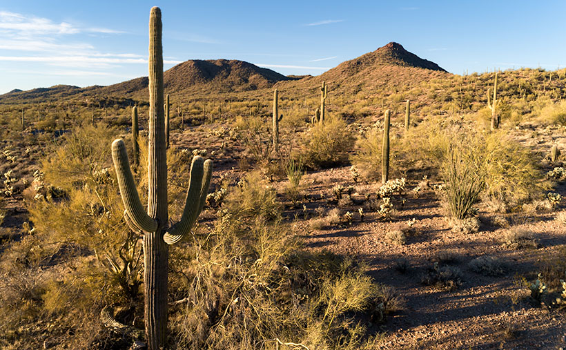
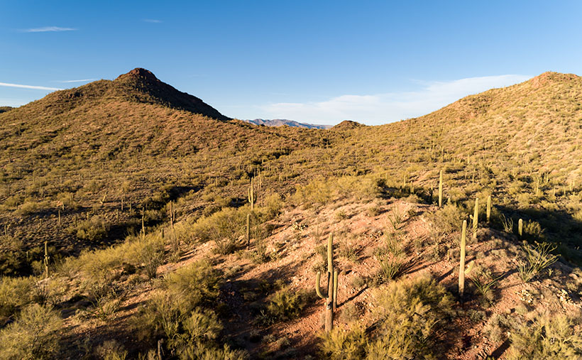
Gates Pass Dawn - Saguaro cacti grow up the side of Bushmaster Peak in dawn's early morning light.
Gates Pass Dawn – Saguaro cacti grow up the side of Bushmaster Peak in dawn’s early morning light.

I shot enough material to tell a story this month in chronological order—a day in Saguaro National Park as it were. I took this week’s featured image in the soft light of pre-dawn—the blue hour. It’s technically not from within the park but was taken from the road along the south side. Speedway Boulevard becomes Gates Pass Road as it heads west toward the Old Tucson movie set. I took this photo at the lookout from the top of Gates Pass. In the image, you can see the copious cacti growing up the slope of Bushmaster Peak—part of the Tucson Mountain Range. I named this image Gates Pass Dawn, and I hope you agree that it’s a great way to start our day of exploring Saguaro National Park.

You can see a larger version of Gates Pass Dawn on its Web Page by clicking here. Come back next week when the sun rises on another image further along the road.

Until next time — jw

Front Yard Trees Picture of the Week

Are you a punctual person, or are you chronically tardy? Our house is split evenly. Queen Anne always manages to be 15 minutes late. Even if I try to compensate by giving her a false time that we should leave to get somewhere, she somehow knows and still isn’t ready on time. One phrase that you will never hear from her is, “Sorry, I’m early.” That is a novel concept to her. It drives me crazy, and she knows it. But then she speaks to me in her low, breathy voice and circles her finger around my remaining chest hair, and then I remember why I love her so much. She’s a good cook—well, she cooks a mean bowl of cereal.

A reason that I’m writing about punctuality is that this year’s monsoons have finally shown up to the party—six-weeks late. One thing that makes Arizona summers bearable is watching majestic thunderheads build up over the mountains in the day and then enjoying the evening thunderstorms from the porch. When the summer rains arrive, they break the extreme June and early July temperatures by about ten degrees. This year, our first rain didn’t come until last week, so it stayed hot through July and August. We had 50 days of temperatures above 115º, a new record. June, July, and probably August will go down as the hottest recorded, and without the refreshing rain, brush fires have plagued the state. The smoke from California and Arizona fires has added to this summer’s miserable conditions.

Things changed last week. Between the gulf flow shifting west and a tropical depression off the coast of Baja, there are pretty clouds in the sky, and the temperatures have dropped—the last couple of days have been under the century mark. As I write and look out my office window, I can see cumulus clouds building towers over the Weaver Range. Maybe we’ll have rain again tonight. I think I’ll go to the car wash and improve our chances.

Front Yard Trees - Tall cottonwood trees grow along the road-side in front of a Ferguson Valley ranch.
Front Yard Trees – Tall cottonwood trees grow along the road-side in front of a Ferguson Valley ranch.

Looking back at the photographs from this month’s portfolio, I wonder how different they might have been, had the skies been more dramatic. Take this week’s featured image; for example—the treetops stand in for clouds. Had the sky been brimming with fluffy cumulus clouds above Baldy Mountain, would I have seen the scene differently? I can visualize that image being less about giant cottonwoods along a rancher’s fence line and more about the mountain in the background. In any case, I have to work within the given conditions, and so I took this week’s photo—called Front Yard Trees—as it was then.

You can see a larger version of Front Yard Trees on its Web Page by clicking here. Next week we’ll begin a new adventure out along another Arizona road, so come back and find out where the trail leads us.

Until next time — jw

Ferguson Valley Picture of the Week

Queen Anne—as my mother would frequently say—is deaf in one ear and can’t hear out of the other. However, she can tell the difference between me calling, “Anne” and the blood-curdling scream, “Aaannee.” I know this to be true because it happened this week when she rushed to my rescue.

I was busy watering the potted flowers that live on the back deck. We keep them there in the shade during the summer, and I have them arranged on the back doorstep, so the bunnies don’t get to them. It doesn’t work because one or two rabbits will scamper off whenever I open the door. I used my cute water can instead of dragging the hose to conserve water. As I finished the mums, I stepped to the left toward the geraniums. There between the two pots was a western diamondback rattlesnake lying in a wad like a pile of tan rope. It laid there motionless while I involuntarily took a couple of steps backward while I screamed in a voice a couple of octaves higher than my normal range.

When she came to see what the fuss was about, I could only stutter, “porch … snake.” She stepped outside and sized up the serpent, then went back into the house. She quickly returned with a long stick that she had used to knock down a hornet’s nest on the front porch. She marched over to the rattler—which hadn’t twitched yet—took a stance, and began whacking at it. The vermin’s head popped up like it had been sleeping and tried to escape to the left. Anne was too quick and outflanked it, then she took a couple more swings at it. Then the legless reptile reversed course and slithered across the landing before it escaped down a gap between the decking and the house.

“Now what’ll we do? What happens now?” I pestered while dancing from foot to foot like I had to go to the potty. She leaned her stick against the house and went inside and called the fire department. I stood watch, ready to run away the moment I saw any movement. When she returned, she assured me, “They said to leave it alone. It knows it’s not loved and will move on when it feels safe again. If we see it again, we’ll call them, and they’ll come to remove it for us.” I was still upset, and I whimpered while nervously rocking back and forth. That’s when she slapped me across the cheek and commanded me to “Snap out of it.” She went back inside and returned with my camera bag and shoved it into my chest and instructed me to “Shut up and get in the truck. We’ll go take some pictures.”

We drove up the mountain to Skull Valley, where it was cooler. Well, it was under a hundred, and that was better than at home. We turned onto a road named Ferguson Valley Road. The dirt trail is only 6-8 miles long, but there was enough material there to keep me busy in August. The route runs by one cattle ranch and ends at a second. I haven’t found any information about this spot on the map, so I’m surmising that the Fergusons must own one of those places.

Ferguson Valley - Against a backdrop of the Sierra Prieta range, a white ranch-house sits in pretty Ferguson Valley.
Ferguson Valley – Against a backdrop of the Sierra Prieta range, a white ranch-house sits in pretty Ferguson Valley.

Perhaps they live in the home seen in this week’s featured image. I called this photo Ferguson Valley, and I spotted this scene as we crossed over a low ridge. I liked how the white ranch buildings contrasted with the juniper and cottonwood. I also wanted the clouds forming over the Sierra Prieta range. They speak to the feeble start of this year’s monsoon season. In a typical year, there would be spectacular thunderheads building in the mountains surrounding Prescott.

It’s been several days since we last saw Fang—yes, we named it—so we’re more cautious when we’re outside. We assume the snake is out there, and we actively search for it as we move about the yard. We’re careful to keep the garage door closed, and we work as a team when exiting the house. Anne stands with her back to the wall—stick in hand—and when I open the door, she swooshes through it, scans the area, and then yells, “Clear!” The swat-team imitation repeats a couple of times until we’ve safely reached the car. I’m better now, but if we have many more rattlers visit us, we’re moving to New Zealand—if they ever let us in again.

You can see a larger version of Ferguson Valley on its Web Page by clicking here. I hope you like it. Be sure to come back next week to see another image from this pretty little valley.

Until next time — jw

Mount Union Picture of the Week

One day, I’m going to stand on top of Mount Everest—or Chomolungma (Mother Goddess of the World) as the Tibetans call it. I’ll to need some help, so I’m waiting until they finish the escalator, and a Starbucks is open at each of the decompression stations. It’s bound to happen. The mountain is already overcrowded, so we may as well wholly ruin the highest spot on our planet. Everybody should get a chance to experience that majestic view once in their life.

I love standing on mountains, canyon edges, and tall buildings. Standing there and taking in the vista enhances my map of the world. We all carry one deep in our hippocampus. It’s our sense of direction, and we probably developed it long before we fell out of the trees. It’s natural for us to want to know what’s over there and where the lions are. It’s a tool that we have located in the most primitive area of our brain. Like all of our other muscles, our spatial map works better when it’s exercised.

When I travel to the mountains like the Bradshaws, I make it a point to stop at the viewpoints and take a look around. Being the nerd that I am, I love it when the Highway Department has those displays that tell you what you’re seeing. I spend so much time studying them that Anne finally wakes up mad in the car. She thinks that I’ve abandoned her at the curb, which is silly because I would never leave the car behind.

The Bradshaw Mountains—or Wi:kañacha, in the Yavapai language (rough, black range of rocks)—have six peaks over 7000 feet. The two highest peaks, named during the Civil War, are Mount Union (7979) and Mount Davis (7897)—yes, Jefferson Davis. They’re located on the same ridgeline less than a mile apart. On the Senator Highway that Queen Anne and I explored this month, there’s a side road that goes to Mount Union and a lookout tower. On the other hand, to reach Mount Davis, there aren’t any trails—you have to hike cross country from the Mount Union picnic area.

Mount Union - Or rather, the view from Mount Union looking east towards the Mazatzals.
Mount Union – Or rather, the view from Mount Union looking east towards the Mazatzals.

This week’s featured image has a name different than how I usually name my work. It’s called Mount Union, and I called it that because of where I stood rather than the image’s subject. This time, I found a place for the camera where trees weren’t in the way and of the several angles that I captured; I liked this version the best. This photo is of the view looking east, and it not only shows the dense pine forest on the mountain’s top, but it also includes the Black Hills that are east of Cordes Junction and on the horizon is the Mazatzal Range. Somewhere in the valley between the mountains is Interstate 17—Arizona’s primary north-south corridor.

You can see a larger version of Mount Union on its Web Page by clicking here. I hope you enjoy seeing it. Be sure to come back next week when we begin a new adventure traveling more of Arizona’s back roads.

Until next time — jw

New Drone Film – The Weaver Mountains The third film in my ongoing series of Arizona Desert Mountain Ranges

I have some excellent news this morning. I posted my third YouTube Video, and it’s ready for you to watch. I admit that in these troubling times, my films are little more than eye-candy, but I’m hoping they give you something nice to watch on TV for a change of pace.

The video is the third in my desert mountain series, and this episode features the Weaver Mountain Range. Those are the mountains that I see every day from my front porch, so in these times of stay-at-home orders, they were a convenient subject.

The reason that I’m producing these films is two-fold. When I look on the net for background on my weekly blog posts, I usually only find a two-paragraph entry in Wikipedia, and if I’m lucky, it may have a photograph or two (usually of historic value). I’m trying to capture these mountains in the ‘now’—a specific season and year—so viewers can see their aesthetic beauty as I do. I’m trying to fill the void of context that these lower ranges are missing. My other reason for these projects is purely selfish. Queen Anne said I could have a drone if it got me out of the house and left her alone. Done and done!

You can view this seven-minute film in several ways. The easiest is to click on the embedded link here in the post above. Or you can see it on your computer by typing this link in your address bar: (https://youtu.be/09knCZ9HY4c). And finally—and I think the best—is to watch it on your smart 4K TV by going to YouTube and search for Jim Witkowski (there are several, but I’m the old guy in the baseball cap). Then, navigate to my Arizona Desert Mountains channel. I hope you enjoy seeing it. Please consider sharing it with your friends and family and clicking on the thumbs-up icon (like-button).

Until next time — jw

Seal Mountain Picture of the Week

I wouldn’t have made a good prospector if I had lived during the Weaver Mountain mining boom. Since it is Father’s Day, a quote from my dad seems especially appropriate today. “You’re nothing but a lazy bastard, and you will never amount to anything.” Thanks, dad. I’ll cherish those words forever. He’s right, though. I don’t even like to water our flowers much less pick at a mountainside. In last week’s post, I was shocked to see in the photograph of my hand, a callous below my ring. Where did that come from—I haven’t touched a hand tool in decades.

If mining is off my list, what else did men do to earn wages back then? To find out, I continued my exploration of the Weaver Range east side by following the other side-roads near Placerita. This week I drove the Wagoner Road down to the Hassayampa River. I’ve never seen that area, and besides, I might get different scenes for my drone film. I struck pay dirt (sorry for the mining metaphor).

The Wagoner Road descends the east slope of the Weavers into a river valley where the Hassayampa flows above ground. As expected, where there’s surface water, there’s farming—or in this case ranching—big ranches. They’re stacked along the river one after another. They have well-maintained fences, impressive gates, and lots of black cattle (although I did see a herd that had Wagyu markings). The valley reminded me of north Scottsdale when it was mostly Arabian horse farms. It would be an ideal place to live except for grocery shopping. There are only two ways out, the 38-mile road back to Kirkland Junction or crossing over the Bradshaw Mountains on the Senator Highway (Wickenburg is only 20 miles distant in a private aircraft, which is possible given the size of these estates).

Seal Mountain - A remote mountain only seen in an obscure valley is the model that was used on the Arizona emblem.
Seal Mountain – A remote mountain only seen in an obscure valley is the model that was used on the Arizona emblem.

Since I was scouting new views of the Weaver peaks, I found a doozy. It’s the mountain that is in the background of this week’s featured image that I call Seal Mountain. Every Arizonian should know this mountain by heart because it was the model used for the Arizona State Seal. In 1912, who knew it existed? The only place you can see this peak is from the ranches in this remote valley. I’m impressed, however, that my local mountain range is represented on the Arizona seal.

The Arizona Seal - If you squint hard, you can see the similarity.
The Arizona Seal – If you squint hard, you can see the similarity. Personally, I would have chosen Four Peaks.

So, could I have been a rancher instead of working in a mine? MMM—maybe not. That kind of work still involves toiling with shovels, rakes, other hand tools, and even possibly riding a horse. Horses don’t like me. The last one that I road said, “Oof,” when I got on. Let’s take a closer look at that state seal—shouldn’t there be a programmer or a Web designer on it? Come to think of it, there isn’t even a real estate agent, and that’s the number one Arizona job.

You can see a larger version of Seal Mountain on its Web Page by clicking here. I hope you enjoy it. Come back next week to see what else we found along the road to Placerita.

Until next time — jw

Placerita Hills Picture of the Week

While having this morning’s coffee, I sat on the front porch and watched the sunrise over the Weaver Mountains. That’s the best view from my house, but there are still homes and trees in the way, so I can only see their tops unless I walk down to the end of the street. Since the elevation here is 1500’ higher than the Phoenix basin, the mornings are still cool—even in June. Because my porch faces east, all of that pleasantness comes to an abrupt halt the second the sun clears the horizon. Then I’m forced to retreat to the back where I have a spectacular view of my neighbor’s shed.

When we moved here almost five years ago, I knew nothing about the Weaver Range other than their name. With time, I learned more about their secrets as I researched the subjects I photographed. I fear that by the time I run out of film, I’ll become a sort of grizzled old Gabby Hayes wandering the Wickenburg streets, wearing a torn cowboy hat, a mouth full of chaw, and spinning yarns about mountain ghosts, so the tourists will give me loose change.

The Weaver’s have been at the center of my attention for a couple of months now because they’re the subject of my third drone video that I’ll finish in a couple of weeks. For the video, I made a list of points to film, and I’ve grappled how to describe the range best. On the way to the Prescott Costco last week, I blurted to Anne, “They’re like a horseshoe wrapped around Peeples Valley.” She said, “Huh?” I probably should have started with some context. Then I came up with a better metaphor. They’re more like the palm of your left hand—not the Michigan one.

The Weaver Range - The geography of the Weaver Range can be summed up on one hand, but you have to use the correct one.
The Weaver Range – The geography of the Weaver Range can be summed up on the one hand, but you have to use the correct one.

Use your imagination. Peeples Valley is the depression in the center, and State Route 89 is your life-line ascending from your wrist up Yarnell Hill to the little town at the pass. The Weaver’s tallest peaks are along with the thumb, and where gated communities of summer homes are. The desert wall (the northern boundary of the Sonoran Desert) is along your wrist. The area under your little finger represents the lower eastern peaks—more like rolling hills. The Hassayampa River separates the Weavers from the Bradshaws. The area that we’re exploring this month is at the base of your little finger.

Placerita Hills - The east flank of the Weaver Range are hills than tall peaks.
Placerita Hills – The east flank of the Weaver Range are hills than tall peaks. On the distant horizon is Weaver Peak which is on the other side of Peeples Valley, and is the range’s tallest peak.

The east flank of the mountain range doesn’t have any soaring peaks, at least not when you drive in from Peeples Valley. The mountains are more like rolling hills, as seen in this week’s featured image that I call Placerita Hills. To get there, you have to drive up a long gradual incline. The hilltops have granite outcrops that are like miniature versions of eastern and southern peaks. In the photo, the dense vegetation is very evident and is a mixture of Manzanita, Scrub Oak, and some others that I’m not able to name. Unlike the desert floor, there’s no space to walk, and it’s easy to understand why cowboys wear chaps. The mule deer that we saw bounced over the brush instead of running through it. It’s incredible to me that the area’s ranchers can raise cattle here.

You can see a larger version of Placerita Hills on its Web Page by clicking here. I hope you enjoy it. Come back next week to see what else we found along the road to Placerita.

Until next time — jw