The Enigmatic Black Mesa: A Striking Basalt Landmark in Arizona Picture of the Week - Sunflower, Arizona

A view of Black Mesa, a pyramid-shaped basalt mountain in the Mazatzal Mountains
The Enigmatic Black Mesa – A stunning basalt pyramid rising majestically in the rugged beauty of the Mazatzal Mountains.

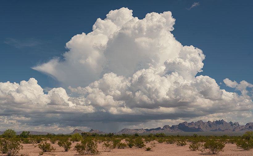
Welcome back to our exploration of the Mazatzal Mountains and the scenic journey along the Beeline Highway. As we continued our expedition, the changes in scenery required frequent stops for pictures. Although the scenery changes with each bend, over the years, the road has undergone its transformation—from a challenging back road to a modern highway.

My love/hate affair with the Beeline Highway began shortly after I arrived in Arizona half a century ago. At the time, I resided in south Scottsdale and had developed a passion for trout fishing. Despite my work obligations, I jumped at any opportunity to escape and make a Payson run. With a left turn at the end of McDowell Road, I could travel the picturesque route in just 90 minutes, reaching the tranquil Rim lakes where I would indulge in the serene beauty of nature and cast my fishing line.

However, weekends brought out the Beeline Highway’s dark side. State Route 87 north of Fountain Hills was a narrow, two-lane rollercoaster that could quickly diminish the joy of driving. While I found the route challenging and enjoyable under normal circumstances, the presence of holiday travelers towing trailers brought the fun to a screeching halt. A comfortable 90-minute journey became a tedious ordeal lasting several hours. These underpowered tow vehicles crawled up the grades at a snail’s pace, followed closely by a long line of frustrated drivers.

During my recent ride with Fred, I was pleasantly surprised by the Arizona Department of Transportation’s significant improvements to the Beeline Highway. The road has undergone a remarkable transformation. It now boasts four lanes for most of its length, except for a couple of long grades where they added a truck lane. The curve radius has been expanded, the shoulders widened, and other safety measures implemented, bringing the highway’s standard close to that of a freeway.

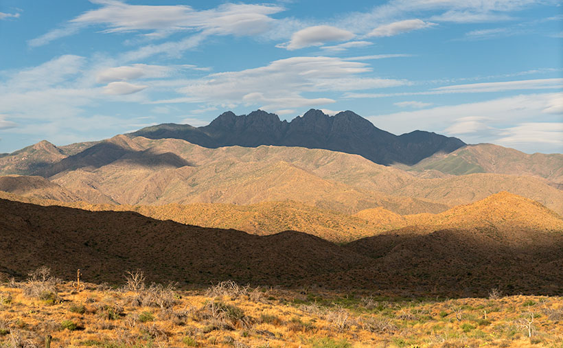
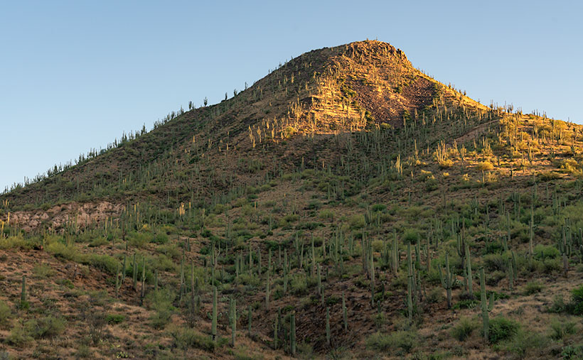
This week’s photograph was captured approximately 10 miles north of Four Peaks, featured in last week’s post. As we continue along the Beeline Highway, the elevation gradually increases, but at this particular spot, we find ourselves at the same elevation as Four Peaks Road. We haven’t gained much altitude because we recently drove over a pass at a large granite field, descending into another valley. Now, we’re beginning the ascent toward a second pass.

When I arrived at this location, the sun had just cleared the horizon, casting its soft light upon the mountaintops. It was the perfect opportunity to pull over and capture this week’s photograph of Black Mesa. Upon closer inspection of the photo, you can observe the traces of volcanism in black basalt trails running down the ravines on the mountain’s face. However, what truly caught my attention in this scene was the abundant presence of saguaro cacti on the southeast-facing slope. They outnumber the Palo Verde trees.

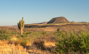
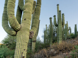
This is the last point on the road where saguaros thrive. Further up this grade, an imaginary frost line marks the limit for these majestic cacti to survive. As we ascend, the winters become too cold for the saguaros to endure. This splendid grove contrasts sharply with the sparse landscape and yellow grass we encountered last week. This week’s second photo was shot near where I stopped to look at a dense cluster of saguaros—the densest I’ve ever seen. It’s a testament to their resilience in this harsh desert environment, especially considering the recent wildfires that have thinned the surrounding landscape.

Close-up of a cluster of saguaro cacti in the Sonoran Desert
Desert Sentinels: Clusters of Saguaros Embracing the Sonoran Desert – A captivating ensemble of saguaros showcasing the beauty of the Sonoran Desert.

I hope you’ve enjoyed the ride so far. I appreciate your company as we explore the captivating landscapes of the Mazatzal Mountains. If you need a little break, I invite you to take some time to immerse yourself in the larger versions of The Enigmatic Black Mesa, available on my website (Black Mesa Webpage) or my Fine Art America upload (FAA Webpage). These images allow you to delve deeper into the beauty and details of this remarkable landmark. And remember, our adventure doesn’t end here. Join us next week as we explore the rugged Mazatzal Mountains on our way to Payson. There are more wonders to discover, and I look forward to sharing them with you.

Till next time
jw

Techniques: Mastering White Balance

Have you ever wondered at the wonky colors some of your photographs have? A simple answer could be the wrong White Balance adjustment. To the human eye and brain, a white sheet of paper looks white outside in the sun, in the shade, under house lights, or fluorescent bulbs. If you shoot using your camera’s raw data file, then you apply that fix in post-processing. But, if you’re shooting JPEGs or videos, the camera does the processing. Usually, cameras (and phones) have an Auto White Balance setting, but the color of a shirt, the distance of the subject, or even the wall color can easily fool it. It’s undependable.

Let’s look at it this way to keep this lesson short and sweet. The color of the sun we grew up and live with is white. If we lived on a different planet with a different sun, our brains would adjust to a new white in a few days. Scientists use the Kelvin scale as a way to measure relative color. It’s a numerical scale to measure the temperature of white light sources. A low Kelvin is warm and has a yellowish cast, so you add blue for balance. A higher Kelvin value is bluish and needs yellow for balance. For example, daylight is typically around 5500K, while tungsten lighting is around 3000K. So if you’re shooting outside, set your camera (or phone) to 5500k (or pick the sun icon), and if you’re using house lights, choose the light bulb icon (or around 3000k).

There are only a couple of exceptional instances. The first is in open shade—you’re out of the sun but under a blue sky, which are the conditions I had shooting this week’s pictures. Here, the light is being bounced off the sky, and the number needs to be higher to offset the additional blue cast. That Kelvin number is around 6500k, or the camera’s shade icon. The second exception is on cloudy days when there’s no blue sky. This is when you set the white balance to 6000k or use the camera’s cloud icon.

There is another infrequent situation that you may run into. It’s when you’re taking your eBay pictures in the garage, someone at a hospital, or a product in a retail store that has old fashion fluorescent tubes. They don’t emit red rays, so things look green. Not only do you have to adjust for the temperature, but you have to add the missing red. If your camera has a tube setting, you’re golden; otherwise, you’re alone.

If I’ve intrigued your interest and you’d like to dive deeper into white balance, numerous educational resources like this are available on YouTube (White Balance Video). You can also search YouTube for tutorials on “color correction” or “white balance” in your preferred post-processing software. There, you’ll find step-by-step guides and demonstrations to help you master this essential technique for getting natural color in your photographs.

Four Peaks: The Crown Jewel of the Mazatzal Mountains Picture of the Week - Fountain Hills, Arizona

Four Peaks in the Mazatzal Mountains: Majestic mountain range against a backdrop of lenticular clouds and blue sky.
Four Peaks: The Crown Jewel of the Mazatzal Mountains – A captivating view of Four Peaks and the dramatic play of lenticular clouds in the Arizona sky.

Yea! We’ve made it over the hump. Now we start whittling away the second half of 2023. But first, we must suffer through the insufferable—our monsoon season. As we enter the scorching summer months in Arizona, fleeing from the heat becomes a top priority for Phoenicians. We seek refuge in the pleasant mountain landscapes outside the city to beat the relentless triple-digit temperatures and humidity. But hey! I’m here to help, so July’s photo project involves one of the escape routes Phoenicians by the thousands use each weekend—the Beeline Highway.

It’s been at least a decade since I last drove Arizona State Route 87, but last month, my friend—and regular contributor—Fred asked me to help him fetch some trailer equipment in Heber—a small community on the Mogollon Rim. As he drove through the rugged mountains to Payson, I rode shotgun and thought, ‘I forgot how spectacular this scenery is. I need to come back with my camera.’ That’s when I decided to do July’s Mazatzal Mountains project and use the Beeline Highway for our trail. It sure beats hiking.

The name—Mazatzal—is a directive of a tribal word the Spanish picked up from the native Indians, Mazatzalli—meaning ankle bone. The Yavapai thought these mountains resembled an ankle when viewed from certain angles. Situated northeast of Phoenix, the Mazatzal Mountains stand as a rugged and formidable barrier, marking the gateway to the Rim Country. These majestic peaks serve as a scenic backdrop for Phoenicians as they embark on their journey to the Mogollon Rim and its surrounding areas. While the Mazatzals offer breathtaking vistas and a sense of natural grandeur, access to their remote backcountry is primarily reserved for avid hikers, horseback riders, and outdoor enthusiasts seeking a more adventurous experience. It’s important to note that due to the rugged nature of the terrain and limited facilities, the Mazatzals may present challenges in terms of accessibility, especially for individuals with mobility restrictions.

As we travel along the Beeline Highway, we traverse a physical distance and ascend through a tapestry of changing climates and vegetation. From the arid lowlands near Phoenix, we gradually ascend into cooler uplands adorned with diverse flora. We witness transition from cacti-dotted desert landscapes to lush pine forests and high-altitude meadows. This elevation-driven change in vegetation is a constant reminder of the varied ecosystems thriving within the Mazatzal Mountains.

This brings us to this week’s image—Four Peaks: the Crown Jewel of the Mazatzal Mountains. This image is my latest attempt to capture the highest point in Maricopa County. Well, they’re the highest four points in the county. From left to right, they’re named: Brown’s Peak (7657′), Brother Peak (7642′), Sister Peak (7572′), and Amethyst Peak (7524′). On the afternoon that Queen Anne and I stopped to take this image, it was windy, and the sky was filled with lenticular cumulus clouds (cirrocumulus clouds that look like lenses). As they crossed the sky, they cast shadows on the mountain, adding depth and drama to the composition. Without the shadows, the mountain would appear flat and featureless.

Thank you for joining us on this virtual journey through the Mazatzal Mountains. We invite you to share your experiences and memories of these stunning landscapes. Feel free to connect with us and the community as we continue exploring this magnificent region’s natural wonders. Stay tuned for our next installment, where we delve deeper into the heart of the Mazatzals.

Sugarloaf and Sycamore Creek: Impressive rock formation and desert landscape in Arizona's back-country.
Sugarloaf: A Gateway to the Majestic Mazatzal Mountains – When the Beeline Highway passes between Four Peaks and this landmark, you know you’re finally out of town and into the Mazatzals.

If you’d like to see a larger version of Four Peaks, you can do that in several ways. The first is to visit its Webpage using this link (https://www.jimwitkowski.com/newWork/fourPeaks.html). Miss Deb reported last week that the second method works only if you use a desktop computer. Follow this link (https://fineartamerica.com/featured/four-peaks-jim-witkowski.html) to my posting on Fine Art America. Please hover your mouse cursor over the image until a green square appears (they’re magically delicious). Select the area you want to inspect, and then click. A one-to-one preview window of that section will open on the screen.

Till Next Time
jw

Techniques: Embracing the Elements and Finding Drama in Nature’s Surprises

Photography is a dance with elements; sometimes, the most captivating images come from natural surprises. As photographers, we can embrace these elements and find beauty and drama in their presence. The photo of Four Peaks with its lenticular cumulus clouds and their resulting shadows is a prime example of how nature can add a touch of magic to our compositions. When faced with unique cloud formations, we may be tempted to wait for them to clear, fearing they will obscure the peaks. However, there is value in embracing the unexpected and capturing the scene as it unfolds. By incorporating the lenticular cloud shadows, the image takes on a new level of depth and intrigue. The shadows play across the rugged mountain terrain, accentuating its contours and adding drama to the composition.

When you find yourself amid nature’s surprises—a sudden storm, an unexpected play of light, or unusual cloud formations—embrace them. Explore their potential to add depth, drama, and a touch of magic to your photographs. Remember, breaking the rules or deviating from your initial plans can lead to some of your most captivating and memorable images.

Bisbee as a Canvas for Artists and Artisans Alike Bisbee, Arizona

Bisbee as a Canvas - . The Old Bisbee Brewing Company mural, created by local artist Doug Quimby, is a prime example of how art and culture have taken center stage in this town.
Bisbee as a Canvas – The Old Bisbee Brewing Company mural, created by local artist Doug Quimby, is a prime example of how art and culture have taken center stage in this town.

Last week, Queen Anne and I treated you to a before-and-after fashion show of Bisbee’s historic buildings. In one corner, we had the Pythian Castle, restored to its former glory by the hard work and dedication of the town’s residents. In the other corner, the Philadelphia Hotel, still in its ‘before’ state, left to daydream about what it could be when it grows up. But now, let’s look from another angle—Bisbee’s artistic side—and see what makes this town shine!

Bisbee, a small town in the Mule Mountains of southeastern Arizona, was once a bustling mining town in the late 19th and early 20th centuries. The town’s buildings were constructed chiefly during its heyday and feature Victorian-style architecture, including ornate ironwork, stained glass windows, and decorative brickwork. The hilly terrain of Bisbee bares a striking similarity to Al Capp’s fictitious town of Dogpatch, known for its unevenly matched cow legs. However, I’ve yet to see anyone in Bisbee with mismatched legs. The steep hills have led to the construction of many unique homes and buildings, with staircases and walkways connecting them to the streets above.

However, as the demand for copper dwindled, so did the mining industry, leaving the town struggling to survive. When Phelps Dodge pulled out of town, 40% of the town’s population did too. It wasn’t until the 1970s that a group of artists and hippies discovered the charm of Bisbee’s historic architecture, mild climate, and rugged landscape and began to settle in the town. Since many of the old homes sat vacant, rent was cheap. But, with migrants came conflict. Power struggles erupted between generations, like when my father told me my photography wasn’t real work. This influx of artists and bohemians eventually transformed the town from a mining town to a thriving hub of tourism and art. Since the mine closings, Bisbee has become a popular destination for those interested in historic preservation. Many of the town’s buildings have been restored and repurposed for modern use while maintaining their original character.

In 1970, artist Stephen Hutchison and his wife Marcia purchased the Copper Queen Hotel from the Phelps-Dodge mining company. The property, which had been vacant for years, needed significant renovation for continued use, but the couple’s decade-long labor of love breathed new life into the town. The Hutchinsons’ dedication to restoring the Copper Queen Hotel was a model for other entrepreneurs, artists, and creative types to invest in Bisbee’s future. The hotel’s Victorian-era architecture, Queen Anne Revival elements, and cozy rooms transport guests to another time and place. At the same time, its elegant restaurant and bar offer a taste of sophistication. The Copper Queen Hotel is a testament to the town’s unique and colorful history and a hub of contemporary hospitality and culture.

Bisbee’s art scene has flourished recently, attracting diverse artists and artisans. From painting and sculpture to jewelry-making and pottery, Bisbee’s art scene is as rich and varied as the town. This starkly contrasts the neighboring town of Tombstone, whose identity is narrowly defined by its Wild West history. As a result, Bisbee has seen a significant increase in tourism, with new businesses and galleries opening up to cater to the growing number of visitors and residents. However, this growth has also brought about concerns, such as rising living costs and impacts on the town’s infrastructure. Additionally, there are questions about how Bisbee will continue to sustain this growth and whether it will eventually reach a saturation point. As Bisbee continues to evolve and grow, it will be interesting to see how the town navigates these challenges while maintaining its unique character and charm.

If Mother Nature had blessed the Mule Mountains with taller peaks and dependable snowfalls, Bisbee’s future would be golden. Legend has it that the Mule Mountains were covered in Douglas fir trees. Today, it’s hard to imagine the landscape before Bisbee’s founders arrived and the trees were harvested to make the town and shore up the mines. But imagine, with those fir trees and a little snow, Bisbee could have been a ski resort rivaling Aspen or Snowmass. I can almost hear the sounds of skiers swooshing down the slopes and the town buzzing with excitement.

The photo for this week’s post—Bisbee as a Canvas for Artists and Artisans Alike—captures the essence of Bisbee’s artistic community. The Old Bisbee Brewing Company mural, created by local artist Doug Quimby, is a prime example of how art and culture have taken center stage in this town. The faded golden characters on the wall portray a lively scene of men at a bar, a bartender, and can-can dancers. The light quality of the mural gives it a nostalgic feel, transporting viewers to another time when the building served as a watering hole for miners. Today, the brewery is a thriving business that has embraced Bisbee’s artistic spirit, creating a rich atmosphere for locals and visitors. The mural on the wall and the European-style architecture of the building are a testament to the town’s unique and colorful history.

Bisbee's "Street Art Exhibition" is a hidden gem waiting to be discovered. This alleyway celebrates creativity and humanity, from the inspirational message of "Let's Be Better Humans" on the stairs to the colorful paintings adorning the buildings.
Bisbee’s “Street Art Exhibition” is a hidden gem waiting to be discovered. This alleyway celebrates creativity and humanity, from the inspirational message of “Let’s Be Better Humans” on the stairs to the colorful paintings adorning the buildings.

Bisbee’s thriving art scene and creative community have played a significant role in transitioning from a mining town to a destination for tourism and the arts. Bisbee serves as a canvas for artists and artisans, with colorful murals adorning the town’s walls and unique galleries and shops offering something for every art lover. We hope you enjoyed this week’s article and encourage you to visit the web version of Bisbee as a Canvas by clicking here to view the accompanying photo. Join us next week as we look at some weird ways Bisbeeites celebrate holidays.

Till next time
jw

KofA Thunderhead Picture of the Week

KofA Thunderhead - An autumn thunderhead builds over the KofA Mountains in western Arizona.
KofA Thunderhead – An autumn thunderhead builds over the KofA Mountains in western Arizona.

Each time Queen Anne and I jump into the car; I pack a camera in the back seat. I don’t mean on local errands like a trip to the grocery store but on drives longer than an hour. Rarely do I stop to take a picture, but should one of those once-in-a-lifetime moments happens, I’m ready.

If I capture some unique photographs, they don’t fit our usual workflow. We usually pick a location as a month-long project and photograph enough shots for a month of articles (or even a book). My one-of-shots along the highway traditionally become forgotten orphans. No one gets to see them—until now.

For December, I decided to make this month’s project out of the non-project shots I collected this year. With these four pictures, a special moment made me pull over and stop the car. That’s pretty hard to do because once I have a destination set in my mind, I only stop for gas, a candy bar, and bladder relief.

Anne and I run to Mexico about four times a year. We go to Algodones to see our dentist and buy 90 days worth of prescriptions. We’re on Medicare, and we have a gap plan that pays for most of the pills we take, but some of the select drugs (hint: you see them advertised on TV) are so much cheaper in Mexico that it pays for the drive. If we don’t have to wait on the dentist, we can make a drug run in a day. We leave here at 8:00 am, walk two blocks across the border, stop at Mickey D’s for lunch, and get home by 5:00 pm.

That was our itinerary on September 22—the first fall day. As we drove home on Highway US 93, I watched a single thunderhead building thirty miles north over the KofA Mountains. I thought it unusual to have monsoon activity in autumn and a single storm cell develop so far west in Arizona. I spent the next half hour arguing with myself.

“That will be a great shot if the clouds hold together until we get there.”

“If we stop, we’ll get home after dark.”

“It’s an isolated cell, and it’s posing like a runway model.”

“It’s the wrong time of day, and the light is wrong.”

Just after passing the Border Patrol station that marks halfway between Yuma and Quartzsite, I noticed that the cloud was beginning to tear apart (the wispy part on the tower’s left side). It was time to stop the car. I reached back for my camera and hiked a few steps off the highway. I set the zoom-lens as wide as possible before framing and then snapping a couple of shots. I call this week’s featured image KofA Thunderhead.

The spot where I stopped was several miles away, and for perspective, the jagged KofA peaks rise a couple of thousand feet above the 500-foot high basin. That makes the billowing cumulus top nearly 40,000 feet in the air. Unfortunately, I didn’t capture any lightning strikes beneath the storm.

We returned to the road and continued the drive, watching the storm evolve. The upper winds blew the clouds apart by the time we were due east of it. That’s when we saw a funnel cloud drop below the ceiling. The tornado briefly touched the ground near Crystal Hill Road before it disappeared.

We weren’t done with it yet. After stopping for gas in Quartzsite, the storm ambushed us on the pass at Guadalupe Mountain. As it moved north over Interstate 10, it dumped rain so hard that the wipers couldn’t keep up, and traffic slowed to a crawl. We hoped we wouldn’t be surprised by a second tornado, but after a mile or so, we broke into the clear, and the deluge was only an image in the mirror.

You can see a larger version of KofA Thunderhead on its Webpage by clicking here. Next week, I’ll drag out another orphan photo for show and tell. We’ll see you then.

Till next time
jw

BTW:

Anne and I are negotiating next year’s schedule, so there will be a lot of yelling and screaming around here during the holidays. Pay no attention to the man behind the curtains.

Lomaki Picuter of the Week

Lomaki - The crooked walls look as if the fierce Northern Arizona winds will blow them over.
Lomaki – The crooked walls look like the fierce Northern Arizona winds will blow them over.

In the half-century that I’ve called Arizona home, I can’t count the times that I’ve traveled thru Flagstaff and then north on Highway U.S. 89. I travel that route to get to the Grand Canyon, Lee’s Ferry, Lake Powell, Monument Valley, Utah, or Colorado. My best guess would be once a year on average. Sometimes I even stop to take pictures along the way.

With that many trips, you’d think I’d pay no mind to the scenery, but that’s not true. There’s always something new. There’s one location that makes my jaw drop, no matter how many times I see it. I’m talking about the view at Sunset Crater Pass I wrote about last month. It’s an in-your-face example of something I learned in a college geography course: mountains affect climate.

The climate on the south side of the San Francisco Peaks is the polar opposite of that on the north. As you travel to Flagstaff from Phoenix, you climb into the pines, and the temperature can drop as much as 30° along the way. As fronts move north from the Gulf in the summer or west from the coast in winter, the mountains wring moisture from the air as it climbs the slopes. After passing over the mountains, the air is dry and picks up pressure on the way down. Dry air heats faster than humid air. The phenomenon creates a rain shadow on the mountain’s leeward side. The next time you travel north of Flagstaff, stop your car at the pass and take a look back—trees. Then turn to the north again—trees kept away.

Now that you know how mountains work, it’s easy to understand why the early Pueblo Tribes living at Wupatki lived in rock dwellings instead of log cabins. Amazingly, the Indians still used timbers to span the walls and hold up a roof. That means they had to drag lumber off the mountains by hand. They built their structures before the Spanish arrived, so they didn’t have horses.

This week we’re looking at one of the bigger pueblos in the National Monument—Lomaki. That’s a Hopi word that translates into English as “Beautiful House.” Anthropologists have partially restored its two-story walls. As you walk through the ruins, you begin to appreciate the ancient people’s masonry skills and tenacity. They must have had to rent scaffolding for walls that size at A-Z Rentals in town. It was either that or standing on one another’s shoulders. You’d do the same thing.

In this week’s picture, titled Lomaki, you get a good idea of the wall height. The windows are at eye level. A peculiar thing you notice in this shot is the walls are leaning. I’m not sure if the scientist put that feature in on purpose or if they weren’t as skilled as the original Pueblo builders. As a photographer, I have a thing about lines that aren’t level or square. Oceans don’t run downhill, so I wince whenever I see a seascape with a crooked horizon. On my first visit to Lomaki decades ago, its tilted walls jumped out at me. They look like a good wind will blow them over—and this area of Arizona is exceptionally windy. However, on this year’s visit, the walls were still standing and didn’t seem any worse, so maybe they’ll remain long after I’ve gone.

You can see a larger version of Lomaki on its Webpage by clicking here. Next week, we’ll walk around Lomaki and see its details. Come back then and see what we find.

Till next time
Jw

BTW:

The calendar cut-off day is Tuesday, so if you are interested, place your order.