Desert Broom and Windmill Picture of the Week

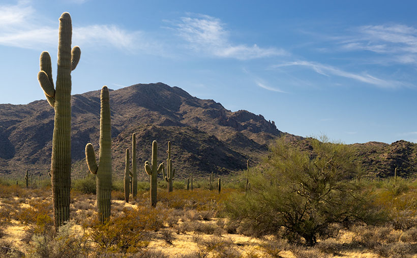
I’ve spent a lot of time in the desert recently. I’m less likely to run into snakes now that the weather is colder. But, there’s still a lot to be wary of when you’re out in the wild. There’s the cactus, especially the Jumping Cholla, the barbed wire, and all the illegal garbage scattered along the trail. One of the most frequent things I have to avoid is all of those cow pies. As I move, my eyes are on the ground; then, I stop to look up to get my bearings. There may not be a cow within miles, but their droppings are everywhere. I Googled it and found a state agricultural Website that said, “Grazing fields account for 73% of total land use in the state and 98% of its agricultural landholdings.” That’s a lot of free-range lands.

Desert Broom and Windmill-The picturesque windmills don't provide an efficient supply of water to cattle as water tables drop
Desert Broom and Windmill-The picturesque windmills don’t provide an efficient supply of water to cattle as water tables drop

You can tell ranching in Arizona is a big deal by the number of windmills and clumps of green trees you see as you drive down the highway. The green areas are usually associated with stock-tanks—the ranchers plow low dams on washes to retain the run-off, and the windmills pump groundwater into large metal tubs from which the herd gets a drink.

Not many of these windmills actually spin these days, regardless of how much the wind is blowing. Some of that is because the water table is dropping. There has been an ongoing drought here, and we’ve pumped enormous amounts of water out of the ground over the years. Instead of drilling the wells deeper, ranchers disable the windmills and truck water in to fill the tanks.

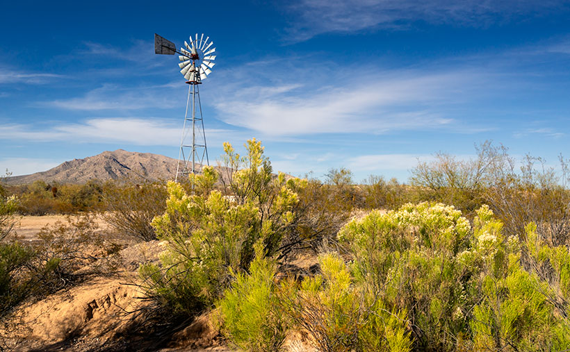
On our “One Lap of the Harquahala Mountains” tour that Queen Anne and I did last month, I was challenged with either shooting the mountain repeatedly, or finding interesting things that broke the monotonous sea of creosote, so when I saw this windmill off in the distance, I hiked in for a shot. When I got there, I liked the shiny metal fan against the sky, but I wasn’t impressed with its doughboy style galvanized tank. It looked as if thirsty bovine stampeded over it. Luckily there was some desert broom nearby that helped in a couple of ways. The green plants were in bloom—that’s as close as you get to fall color in the Sonoran Desert, and they camouflage the damaged tank.

I named this week’s featured image Desert Broom and Windmill. I like how the light was beginning to come in and how Harquahala Mountain shows in the background. I’m also partial to the high cirrus clouds, so I was pleased that they frame the windmill’s blades.

You can see a larger version of Desert Broom and Windmill on its Web Page by clicking here. I hope you enjoy viewing it. Join us next week as we continue along our trip around the Harquahala Mountains.

Until next time — jw

Saguaro at Harquahala Mountain Picture of the Week

I was researching today’s post, and I found some interesting statistics—at least they are for me—and on an online forum thread that made me smile. In case you hadn’t noticed, I like mountains. I like them big or small, a long chain of peaks or lonesome butte, snow-covered volcanoes or desert ranges. I like them because they’re not flat and they’re visually stimulating. You can gauge travel distances with them. I’d be a terrible mariner out on the sea without landmarks. When I travel through Kansas, I have to replace peaks with grain silos.

I want to learn more about what I see and photograph. I want to know the peak names, their heights, their make up, and how they formed. Most of my curiosity is satisfied with topographic maps, but the geology stuff is gobbledygook.  I wish there were an easy decoder book written for simpletons like me.

The Harquahala Mountains—the subject of this month’s images—are a substantial range, one of the highest in Arizona’s southwest quadrant. I can see its distinctive round shape from my back porch. I started tagging my films with the name Harquahala Studios because it’s fun to say: HARK—qua-hala. Last week I learned that the name in the Mohave language means “water, up high” presumably from the springs on its slopes—a handy fact to know if you live in the desert.

I Googled “Arizona Mountains” this morning and found it listed in the 5,000-6,000 foot elevation group. To find the exact answer that I wanted would have required more research, spreadsheets, and an effort that cut into my nap, so I gave up. But I saw another question in the list that piqued my curiosity. “Which state is most mountainous?” What’s your guess? Set aside Alaska because they don’t play fair. Is it Colorado, California, or Montana? In the discussion, some people were arguing that it’s West Virginia, which is in the Appalachians, and the highest peak is under 5,000 feet—hardly a mountain. They explained that the little state has the lowest percentage of flat-land, so it’s all mountains, therefore the most mountainous.

The answer wasn’t Colorado; California has 500 more named peaks, and Montana is two-thirds prairie that the locals call West Dakota. The response surprised me, but since I read it on the internet, it must be true. Being entirely comprised of the Great Basin Desert with north-south running ranges, Nevada has the most named peaks in the lower forty-eight. They’re not the highest, but there’s a gob of them.

Saguaro at Harquahala Mountains-A line of saguaro looking like telephone poles lead your eye to the massive mountain south of Aguila, Arizona.

This week’s featured image is called Saguaros at Harquahala Mountain, and I shot it south of Aguila, a few miles south of the Eagle Eye Peaks in last week’s post. What made me stop to take this image was the line of saguaros that looked like a row of telephone poles. They create what’s called a leading-line—a perspective tool that brings your eye into the massive mountain. The clouds and the small Palo Verde tree work to keep your attention in the picture’s center—if it works right, your eye moves in a clockwise circle.

You can see a larger version of Saguaro at Harquahala Mountain on its Web Page by clicking here. I hope you enjoy viewing it. Join us next week as we continue our lap around the Harquahala Mountains, and remind me to stay out of the flooded washes.

Until next time — jw

Apostrophe Butte Picture of the Week

I’m down to the last page on my calendar this morning. It’s already time to get a new one. Einstein may have been right about time being relative, but I think he got it backward. Instead of the clock slowing down as you travel faster, time speeds up as you age. Don’t you remember how a week dragged when you had a date on Saturday night? Now it seems like Queen Anne, and I make our weekly run to the garbage dump every other day. What upsets me is that there’s little time for my daily naps anymore.

With a new month comes a new road to explore. We’ve had an extended summer, and it has been a very dry fall, so I initially thought that her majesty and I could go into the mountains. But that all changed recently and we’ve had wave after wave of Pacific storms roll through. Being less daring than I was, I changed my mind and looked for a closer route. One that wouldn’t have snow or mud, or maybe wasn’t even dirt. I mean, we’ve all watched the local heroes on the evening news as rescuers drag them from flooded washes. I’ll only go so far for free-press.

So, I packed the camera, some snacks, and my wife for a lap around Harquahala Mountain using three roads, a triangle of sorts. I’ve driven these roads several times, but not for a photography outing. We started in our neighboring town of Aguila, an agricultural community at the east end of the McMullen Valley. From downtown—the Family Dollar store—we headed south on Eagle Eye Road to the Salome Highway and back to Aguila on U.S. 60. If we weren’t stopping for pictures, we could cover the entire loop in three hours, and the Harquahala Range was out the passenger window the whole time (In the Mohave language, Harquahala translates into: “running water high up“).

Apostrophe Butte - South of Aguila, I think Eagle Eye Mountain is a presumptuous name for this little hill, so I renamed it.
Apostrophe Butte – South of Aguila, I thought Eagle Eye Mountain is a presumptuous name for this little hill, so I renamed it.

We didn’t even get out of town before our first photo stop. Just past the gated airpark—where wealthy Anguillans live—is the town cemetery at the foot of Eagle Eye Mountain. There are two piles of volcanic rock sitting side by side along the highway. The east one is called Eagle Eye Peak, and it has a big hole in it. I’ve written about it before. The shorter western one is called a mountain, which is a generous description at best. It’s hardly a couple of hundred feet high. Compared to the massive Harquahala Range west of the highway, they’re hills. They rise from the surrounding plains, and I’m unclear if they’re part of the Vulture Mountains—15 miles due east, or they are foothills of the western more significant mountain range. Still, they were cute enough to stop and compose a picture.

From the spot where I shot this week’s featured image, I thought that it looked like a punctuation mark, because of the overhang at the top. After further thought, I came up with Apostrophe Butte, which I think is more fitting. All I have to do now is to petition the Department of Names—or whatever you call it—to correct Arizona maps.

You can see a larger version of Apostrophe Butte on its Web Page by clicking here. I hope you enjoy viewing it. Join us next week as we continue our trip around the Harquahala Range.

Until next time — jw

The Boulders Picture of the Week

As we continue our journey east along the Florence-Kelvin Highway, we leave behind the dry washes and haunted valleys of the Tortilla Mountains. We reach a crest where the land becomes a flat plain of sorts. There are small mountain peaks—big hills really—dotting the countryside here and there, but the view is more open, and it seems less appealing now.

Without the mountains and gulleys, the road has long straight sections, and although it appears to be flat, it’s a long downhill slope into Florence. The elevation drops almost a thousand feet over the next ten miles. Just after passing the Tea Cup cattle ranch on the road’s north side, we spot a field of granite boulders that Google Maps identifies—oddly enough—as The Boulders.

The Boulders-Another outcrop of granite deposit found throughout the state of Arizona.

The boulders that you find at The Boulders are the same pile of granite rocks found in Prescott, up the hill from here in Yarnell, Kingman, or any other place throughout Arizona. They’re everywhere. Instead of turquoise, the state legislature should have designated these granite deposits as the state gemstone, but, like Ben Franklin’s idea of making the turkey the national bird, granite just lacks pizzazz—except on your kitchen countertops.

Because the rocks stand out like a sore thumb along the road, I had to stop to take some more rock pictures. There are a couple of good campsites here. In fact, on our visit, a motor-house and fifth-wheel were doing just that nearby, so The Boulders is a popular place. As I clambered in, on, and among the rocks, I looked for a composition that distinguished this outcrop. The image that I chose to present this week was one that was covered with graffiti. I’m always flabbergasted how some people love to get out in the wild and are then compelled to mark it up with spray paint.

I call this week’s featured image The Boulders, and I like it for a couple of reasons. One is the contrast of small against the big; the other is the shadow against the light. I’ll throw in the wall-art at no additional charge. Another thing in this image that I find interesting is the Tortilla Mountains barely visible on the horizon. It shows the amount of distance Queen Anne and I have traveled.

You can see a larger version of The Boulders on its Web Page by clicking here. I hope you enjoy viewing it. Next week, we’ll finish up our trip along the Florence-Kelvin Highway and I have a surprise to show you—something I’ve seen in pictures, but never in person.

Until next time — jw

Ray Tailings Picture of the Week

Queen Anne's directives - From her royal coach, Anne delights in pointing the way we should've gone.
Queen Anne’s directives – From her royal coach, Anne delights in pointing the way we should’ve gone.

Picking a new back road to explore, photograph, and talk about is easy for some months. I may have seen a place that piqued my curiosity, and I’m ready to go. Other months are hard. I’ll pour over my maps, hoping to find inspiration. This month was different. When Queen Anne told me that she wanted to visit an ex in Florence (1), I knew right away which trail we’d be talking about in November. Of course, we’d pick the Florence-Kelvin Highway.

The highway between Florence and Kelvin is a 34-mile shortcut between the towns. Although it’s 13 miles shorter, driving around the Tortilla Mountains and through Superior using the paved highways is faster. I’ve partially traveled this road before when I photographed the Cochran site—the ghost town where only the coke ovens remain. They paved sixteen miles of the highway between Florence and the Cochran Road. It’s a long gentle grade rising 1500 feet. Then it winds through the Tortilla Mountains, past a couple of ranches, before descending into Kelvin—a small community along the north bank of the Gila River. Although there may be some wash boarding between gradings, the dirt is broad and doesn’t require a particular vehicle.

On this trip, Anne and I drove east to west, so we’d be somewhat closer to home. From Congress, we drove two and one-half hours to Superior, and most of that time was spent getting to the other side of Phoenix. In Superior, we turned south on County Road 177 to Kelvin—a community so small it doesn’t even have a Dollar Store. Something that Kelvin does have is the Ray open-pit copper mine currently managed by the Mexican mining company, Asarco. And it’s where I photographed this week’s featured image that I call Ray Tailings.

Ray Tailings - A 500-foot tall inside out mountain of mine tailings.
Ray Tailings – A 500-foot tall inside out mountain of mine tailings.

This operation is so massive that you see it on the east side of the highway for a couple of miles. The central pit—Jimmie Luck Gulch—looks like it could be used to mold giant Devo hats (“Whip it good“). In the middle of the Dripping Spring Range, the mineworkers have dug a negative mountain with terraces that the behemoth trucks use to haul ore to the surface. Digging that much dirt out of the ground to remove the copper, you have to stack the sterile waste somewhere, and that’s what I photographed for this week’s issue. It’s the mountain stacked up—inside out. The minerals found beneath the surface colors each layer. To me, the 500-foot pile looks like a gay-pride wedding cake.

It’s an impressive bit of technology to see, but it also causes environmental problems. Because the rocks and dirt are devoid of nutrients, unless scientists intervene, it will take centuries for plants to colonize the tailings. So that makes them susceptible to accelerated erosion. With each heavy rain, bit by bit, the pile makes its way into the Gila River and eventually the Sea of Cortez. That’s not good for the downstream people who rely on the river for clean water (Arizona Copper Co. vs. Gillespie).

You can see a larger version of Ray Tailings on its Web Page by clicking here. I hope you enjoy viewing it. Next week, we’ll continue along the Florence-Kelvin Highway, and I’ll show some of the natural beauty we found there.

Until next time — jw

(1). For those of you that live in another state, or don’t get the joke, Florence is the location of Arizona’s State Prison. She doesn’t really know anyone incarcerated there, but that’s not as funny.