New Drone Film – The Weaver Mountains The third film in my ongoing series of Arizona Desert Mountain Ranges

I have some excellent news this morning. I posted my third YouTube Video, and it’s ready for you to watch. I admit that in these troubling times, my films are little more than eye-candy, but I’m hoping they give you something nice to watch on TV for a change of pace.

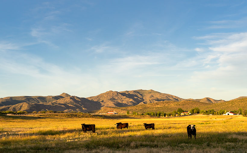
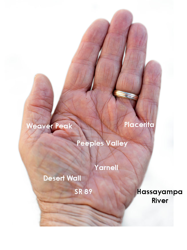
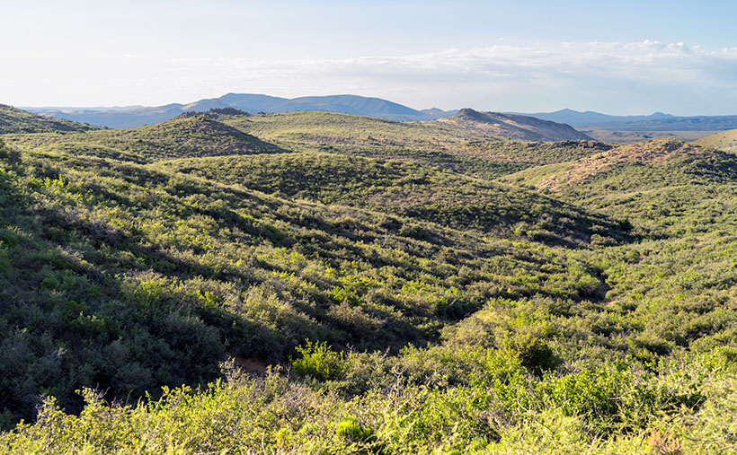
The video is the third in my desert mountain series, and this episode features the Weaver Mountain Range. Those are the mountains that I see every day from my front porch, so in these times of stay-at-home orders, they were a convenient subject.

The reason that I’m producing these films is two-fold. When I look on the net for background on my weekly blog posts, I usually only find a two-paragraph entry in Wikipedia, and if I’m lucky, it may have a photograph or two (usually of historic value). I’m trying to capture these mountains in the ‘now’—a specific season and year—so viewers can see their aesthetic beauty as I do. I’m trying to fill the void of context that these lower ranges are missing. My other reason for these projects is purely selfish. Queen Anne said I could have a drone if it got me out of the house and left her alone. Done and done!

You can view this seven-minute film in several ways. The easiest is to click on the embedded link here in the post above. Or you can see it on your computer by typing this link in your address bar: (https://youtu.be/09knCZ9HY4c). And finally—and I think the best—is to watch it on your smart 4K TV by going to YouTube and search for Jim Witkowski (there are several, but I’m the old guy in the baseball cap). Then, navigate to my Arizona Desert Mountains channel. I hope you enjoy seeing it. Please consider sharing it with your friends and family and clicking on the thumbs-up icon (like-button).

Until next time — jw

Seal Mountain Picture of the Week

I wouldn’t have made a good prospector if I had lived during the Weaver Mountain mining boom. Since it is Father’s Day, a quote from my dad seems especially appropriate today. “You’re nothing but a lazy bastard, and you will never amount to anything.” Thanks, dad. I’ll cherish those words forever. He’s right, though. I don’t even like to water our flowers much less pick at a mountainside. In last week’s post, I was shocked to see in the photograph of my hand, a callous below my ring. Where did that come from—I haven’t touched a hand tool in decades.

If mining is off my list, what else did men do to earn wages back then? To find out, I continued my exploration of the Weaver Range east side by following the other side-roads near Placerita. This week I drove the Wagoner Road down to the Hassayampa River. I’ve never seen that area, and besides, I might get different scenes for my drone film. I struck pay dirt (sorry for the mining metaphor).

The Wagoner Road descends the east slope of the Weavers into a river valley where the Hassayampa flows above ground. As expected, where there’s surface water, there’s farming—or in this case ranching—big ranches. They’re stacked along the river one after another. They have well-maintained fences, impressive gates, and lots of black cattle (although I did see a herd that had Wagyu markings). The valley reminded me of north Scottsdale when it was mostly Arabian horse farms. It would be an ideal place to live except for grocery shopping. There are only two ways out, the 38-mile road back to Kirkland Junction or crossing over the Bradshaw Mountains on the Senator Highway (Wickenburg is only 20 miles distant in a private aircraft, which is possible given the size of these estates).

Seal Mountain - A remote mountain only seen in an obscure valley is the model that was used on the Arizona emblem.
Seal Mountain – A remote mountain only seen in an obscure valley is the model that was used on the Arizona emblem.

Since I was scouting new views of the Weaver peaks, I found a doozy. It’s the mountain that is in the background of this week’s featured image that I call Seal Mountain. Every Arizonian should know this mountain by heart because it was the model used for the Arizona State Seal. In 1912, who knew it existed? The only place you can see this peak is from the ranches in this remote valley. I’m impressed, however, that my local mountain range is represented on the Arizona seal.

The Arizona Seal - If you squint hard, you can see the similarity.
The Arizona Seal – If you squint hard, you can see the similarity. Personally, I would have chosen Four Peaks.

So, could I have been a rancher instead of working in a mine? MMM—maybe not. That kind of work still involves toiling with shovels, rakes, other hand tools, and even possibly riding a horse. Horses don’t like me. The last one that I road said, “Oof,” when I got on. Let’s take a closer look at that state seal—shouldn’t there be a programmer or a Web designer on it? Come to think of it, there isn’t even a real estate agent, and that’s the number one Arizona job.

You can see a larger version of Seal Mountain on its Web Page by clicking here. I hope you enjoy it. Come back next week to see what else we found along the road to Placerita.

Until next time — jw

Placerita Hills Picture of the Week

While having this morning’s coffee, I sat on the front porch and watched the sunrise over the Weaver Mountains. That’s the best view from my house, but there are still homes and trees in the way, so I can only see their tops unless I walk down to the end of the street. Since the elevation here is 1500’ higher than the Phoenix basin, the mornings are still cool—even in June. Because my porch faces east, all of that pleasantness comes to an abrupt halt the second the sun clears the horizon. Then I’m forced to retreat to the back where I have a spectacular view of my neighbor’s shed.

When we moved here almost five years ago, I knew nothing about the Weaver Range other than their name. With time, I learned more about their secrets as I researched the subjects I photographed. I fear that by the time I run out of film, I’ll become a sort of grizzled old Gabby Hayes wandering the Wickenburg streets, wearing a torn cowboy hat, a mouth full of chaw, and spinning yarns about mountain ghosts, so the tourists will give me loose change.

The Weaver’s have been at the center of my attention for a couple of months now because they’re the subject of my third drone video that I’ll finish in a couple of weeks. For the video, I made a list of points to film, and I’ve grappled how to describe the range best. On the way to the Prescott Costco last week, I blurted to Anne, “They’re like a horseshoe wrapped around Peeples Valley.” She said, “Huh?” I probably should have started with some context. Then I came up with a better metaphor. They’re more like the palm of your left hand—not the Michigan one.

The Weaver Range - The geography of the Weaver Range can be summed up on one hand, but you have to use the correct one.
The Weaver Range – The geography of the Weaver Range can be summed up on the one hand, but you have to use the correct one.

Use your imagination. Peeples Valley is the depression in the center, and State Route 89 is your life-line ascending from your wrist up Yarnell Hill to the little town at the pass. The Weaver’s tallest peaks are along with the thumb, and where gated communities of summer homes are. The desert wall (the northern boundary of the Sonoran Desert) is along your wrist. The area under your little finger represents the lower eastern peaks—more like rolling hills. The Hassayampa River separates the Weavers from the Bradshaws. The area that we’re exploring this month is at the base of your little finger.

Placerita Hills - The east flank of the Weaver Range are hills than tall peaks.
Placerita Hills – The east flank of the Weaver Range are hills than tall peaks. On the distant horizon is Weaver Peak which is on the other side of Peeples Valley, and is the range’s tallest peak.

The east flank of the mountain range doesn’t have any soaring peaks, at least not when you drive in from Peeples Valley. The mountains are more like rolling hills, as seen in this week’s featured image that I call Placerita Hills. To get there, you have to drive up a long gradual incline. The hilltops have granite outcrops that are like miniature versions of eastern and southern peaks. In the photo, the dense vegetation is very evident and is a mixture of Manzanita, Scrub Oak, and some others that I’m not able to name. Unlike the desert floor, there’s no space to walk, and it’s easy to understand why cowboys wear chaps. The mule deer that we saw bounced over the brush instead of running through it. It’s incredible to me that the area’s ranchers can raise cattle here.

You can see a larger version of Placerita Hills on its Web Page by clicking here. I hope you enjoy it. Come back next week to see what else we found along the road to Placerita.

Until next time — jw

Warm Springs Cholla Picture of the Week

This morning, when I got out of bed and looked in the bathroom mirror to see if I still had a reflection, I scared myself. What little hair that I still have was standing perpendicular to my head. I think I stuck my finger in a light socket last night. I’m puzzled at how the remaining five hairs on the top of my head—which are invisible when I comb them—manage to stick straight up like a coastal lighthouse. A less intelligent Albert Einstein stared back at me. I need a haircut.

When I got out of the Army, I had thick wavy red hair, and I went to a salon every other week to get it styled. I was on the hunt for a mate back then, so I had to look my best. I patronized one of those places that charged more because they cut your hair with a razor. I paid $30 for a wash, cut and blow-dry. I spent too much time each day trying to get that Glen-Campbell-look that was popular then. Then came the 70’s, and we just let our hair grow long. When my hair curled over my ears like Bozo the Clown, it was time to go to Floyds.

I turned gray when I was in my thirties, and suddenly I was an old man. As my hairstyle paid fewer dividends, I gave up and started combing it straight back. I only got a haircut three or four times a year, whether I needed it or not. Now I visit the barber when we make a Mexican pill-run. It’s cheaper there, and—because I’m a senior—I get a discount. The tip is more than the cut, and I still get change. I don’t even care what it looks like as long as it’s shorter than when I walked in.

We’ve suspended our trips to Algodones during this pandemic, so I’m taking matters into my own hands. I ordered hair-clippers from Amazon. They were supposed to be here on Friday but didn’t arrive. I’ve worked up the nerve to let Queen Anne put it on the shortest setting and shave it all off. How bad could it be? Besides, that’s why I have hats.

The day that Queen Anne and I traveled down Old Route 66 was the exact opposite of a ‘bad hair day’ (see how I did that?). The trip produced more good images than I usually get, and with good reason. The Black Mountain Range is an exciting pile of rocks. I can see me spending more time exploring them—especially when one of you coughs-up the funds for my hover-bike.

Warm Springs Cholla - Cholla along the roadside provide a good foreground contrast for McHeffy Butte at sunset.
Warm Springs Cholla – Cholla along the roadside provides an excellent foreground contrast for McHeffy Butte at sunset.

This week’s featured image is called Warm Springs Cholla. As you can tell from the colors, I took it as the sun was setting. We were several miles south of Oatman, and I was studying a  peak—McHeffy Butte—as we drove along. Suddenly (ta-da), a patch of cholla popped up, making a perfect foreground. After I stopped the truck, I hiked a short distance uphill into the Warm Springs Wilderness and fired off a couple of shots. I think the resulting image makes a great wrap-up to our Route 66 trip.

You can see a larger version of Warm Springs Cholla on its Web Page by clicking here. I hope you enjoy it. Next week is June and another back road adventure. I hope you’ll come back and hear about our road trip.

Until next time — jw

White Bluff Picture of the Week

For most of the 1200 miles between Oklahoma City and Barstow, Route 66 and Interstate 40 are stuck together like a zipper. As you drive along the freeway—started in 1957 and completed in 1984—you can see a ghost of the old mother road on the roadside. Sometimes it’s a frontage road with little traffic, in different spots the pavement is gone, and it’s not a road at all.

Arizona has two exceptions to these overlying trails. The first is where Interstate 40 cuts off Peach Springs between Kingman and Seligman, and the second is between Kingman and Needles. In the first case, the freeway cuts miles off the trip by heading straight across country, while the latter deviation is further (albeit quicker) as it skirts the Black Mountain Range.

The section of the historic road that Queen Anne and I explored this month cuts through a mountain pass that Captain Lorenzo Sitgreaves mapped in 1851. Although the trail has beautiful scenery for me to photograph, it is very twisty and slow going, and that’s not ideal for interstate commerce.

Cool Springs Station - A historic gas station converted to a gift shop that now sells hot dogs from a cart.
Cool Springs Station – A historic gas station converted to a gift shop that now sells hot dogs from a cart.

After we finished photographing Thimble Mountain seen in last week’s post, we continued along the road for less than a mile, where we stopped at an old gas station called Cold Springs. The owners have converted it into a gift shop that sells nostalgic Route 66 kitsch, but there were no customers. As I snapped a few pictures, a woman’s voice came from the shadows, “Hello there. How ya doin’?” When I took off my sunglasses, I saw a young woman sitting in the shade next to a hot dog cart. We made small talk, and I asked about her business. “April is normally our best month, but this year it’s a bust.” After promising not to include her in my photos, I took another shot or two before we drove away. Looking back, we should have bought our dinner there. She could have used the money, and her food was probably better than the drive-through meal we got at the Kingman Carl’s Jr.

As we drove further, we had to stop almost immediately again, where the canyon narrowed. On the road’s north side was a pair of sandstone bluffs rising from the dry creek bed. Their cliffs glowed in the late afternoon sun, so of course, I had to capture the moment on film … er, I mean electrons. I’ve since found out that at this location, the road passes between two wilderness areas. To the north is the Mt. Nutt Wilderness, while on the road’s south side is the Warm Springs Wilderness area.

White Bluff - The vertical sandstone cliff of a bluff provide a great home to nesting swallows.
White Bluff – The vertical sandstone cliff of a bluff provides a great home to nesting swallows.

In this week’s featured image—called White Bluff—you can see Mt. Nutt in the distance. At over 5100 feet it is the tallest peak in the Black Mountain Range. To get any closer, you’ll have to hike or grab one of the local wild burros—of which there are many—and ride.

You can see a larger version of White Bluff Butte on its Web Page by clicking here. I hope you enjoy it. Next week, we’ll travel over the pass and make a stop in Oatman. I hope you’ll join us then.

Until next time — jw