Poughkeepsie Gulch Picture of the Week

Even though we had to wing it, I think that the day in the mountains Fred and I had was a very successful adventure. We both got a lot out of it. Fred was able to put his—new to him—Toyota FJ through its paces, we saw some beautiful rugged country, we took a lot of pictures, and we came back in one piece. When we got back to base camp, our wives—Deb and Queen Anne—knew we had a good time from the big bug-stained grins on our faces, and the incessant chattering about our day.

We visited four of the two dozen high passes in the San Juan Mountains, and those were the day’s high points (pun intended) of our trip. Coincidentally, that’s enough material for a typical month’s worth of blog posts. But September has five Sundays this year, so I get to show you another picture that I took; of the twenty-two keepers, this one is my favorite.

I don’t usually work this way. When I’m out alone with my camera, I try to work a scene. I’ll shoot several angles, zoom in and out, add or remove elements in the composition, or maybe wait for better light. When I’m back at my desk, I’ll review the raw files and pick out the best. I don’t bother processing most of my shots. In Colorado, we covered a lot of area in one afternoon, and I was just along for the ride, so I snapped pictures when I could before moving on. For most of the day, the light wasn’t to my liking, but the mountains were strong enough to stand up in less than ideal conditions. As dinner time approached, the sun’s color began to warm, and the scattered clouds cast shadows on the peaks.
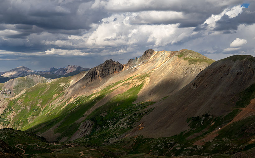
Poughkeepsie Peak - The late afternoon sun shines on the top of Tuttle Mountain, which overlooks Poughkeepsie Gulch.
Poughkeepsie Peak – The late afternoon sun shines on the top of Tuttle Mountain, which overlooks Poughkeepsie Gulch.

We were almost done for the day, and as we approached Hurricane Pass, I saw this scene on the road overlooking Como Lake. I consider it the best of the day. It’s the fish you pull from the creel after the guys have finished laughing at the other minnows from your basket. It’s called Poughkeepsie Gulch. In this image, the warm afternoon sun is shining through a hole in the clouds on Tuttle Mountain’s top, which is otherwise covered in cloud shadows. The 13,203’ peak overlooks Poughkeepsie Gulch and down there, you can see the road the rangers warned us was too advanced for amateurs like us.

You can see a larger version of Poughkeepsie Gulch on its Web Page by clicking here. I hope you enjoy viewing it. Be sure to come back next week when we feature the scenery from another Arizona back road.

Until next time — jw

Sun Showers Picture of the Week

The day was getting late, and before Fred and I could go back, we needed to find one final pass to cross and return to Silverton—and eventually Durango. When we stopped to enjoy Lake Como—last week’s photo—it turns out that we were already near Hurricane Pass. Unlike the other passes, we didn’t have to crawl down one mountainside and up another. Instead, the road followed the ridgeline for a half-mile, and voila.

Unfortunately, Hurricane Pass wasn’t as photogenic as the others that day. The road simply turned east for a bit before disappearing down a crack. Of course, the crack opened into a gulch, then a river valley as we descended 5,000 feet into civilization. It was an anticlimactic way to end the day. The trail was soon gravel followed quickly by asphalt; with guardrails, of all things.

Sun Showers - Although small clouds filled the sky, the only rain we got was a sun-shower.
Sun Showers – Although small clouds filled the sky, the only rain we got was a sun-shower.

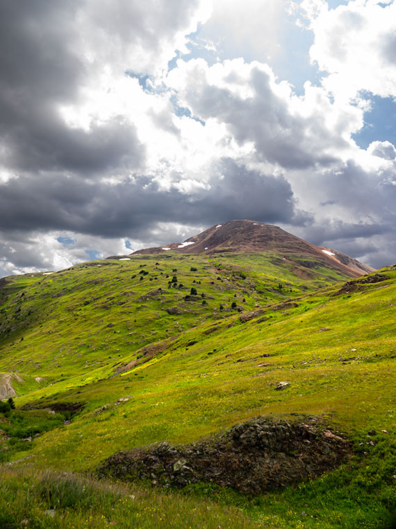
But don’t worry, I come bearing gifts. All during our outing, puffy little clouds filled the sky. They seemed to bump into one another like the balls on a billiard table. Then they would part again leaving large patches of blue sky. On our way down the hill, it started to rain—while the sun was shining. As we rounded a bend in the road, the sun appeared in one of those patches and backlit the mountainside. It’s one of those moments where the grass becomes iridescent and glows. I’ve seen this before in New Zealand. I failed to capture it there, but I think this week’s image is close. I call it Sun Showers. The mountain that we’re looking up as maybe Hurricane Peak, but I’m not sure. In case you’re wondering—yes, those are the Sun’s rays at the top. Did I tell you about the steep angles we experienced during this trip?

You can see a larger version of Sun Showers on its Web Page by clicking here. Be sure to come back next week when I’ll show you my favorite image from our adventure exploring Colorado’s San Juan Mountains in Fred’s Toyota—oh, sorry—Fred’s Jeep.

Until next time — jw

Lake Como Picture of the Week

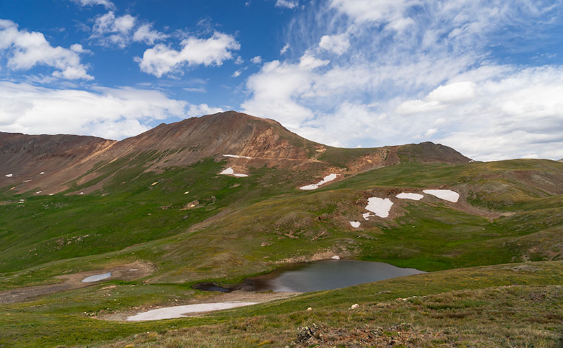
Lake Como as seen from the top of Calaifornia Pass.Lake Como – A little alpine lake from California Pass in Colorado’s San Juan Mountains.

Something is intoxicating about standing on a mountaintop. You get a sense of accomplishment—an incredible buzz—while taking in the view. As you spot familiar landmarks, the map you carry around in your mind gets updated. I can understand the addition mountain climbers have to the highest peaks. I’m just too lazy to be one of them, and you won’t catch me on the climbing wall at the local gym—or inside the gym in the first place. Spending a day with Fred driving his FJ up-high passes in the San Juan Mountains was good enough for me.

When we decided not to spend all day driving Colorado’s Alpine Loop but drove up two of its passes, we wanted another challenge. The first ascent was scary, while the second was not so much. I felt like a kid on a swing urging his parents to push harder. “Again,” I shouted. So, we stood on Engineer Pass with the map spread over the hood, looking for another route back to Silverton. After all, we didn’t want to go back down the way we came. That was along the Animas River and was flat and dull. We agreed on a route that would take us over two more passes before dropping back to Silverton via Cement Creek, and that meant that we’d have first to drive back down to Animas Forks.

From the ghost town, we headed west up California Gulch. Going in this direction, the road ran straight ahead for several miles and appeared to end midway up California Mountain. Several times, I’ve traveled roads without a clue what’s ahead. For example, Interstate 15 is heading north out of Mesquite, Nevada. As it leads for the Beaver Mountains, you can’t pick out where the freeway climbs over them. I always involuntarily back out of the gas in case the road suddenly ends—like against the mountainside. At the very last moment, the Virgin River Gorge opens and swallows the highway. I was getting that feeling now.

It wasn’t until the perceived end of the road that it turned on itself and climbed behind a side ridge that hid the route from below, and as we drove around the bend, the trail went vertical. I questioned our decision to go this way because this was undoubtedly the beginning of the roller coaster from hell. Fred managed to keep all four wheels on the ground while his truck grunted its way up the grade. When we reached the top, as with the other passes, there was a spot to park and look around. When I got out, I decided a box of Depends would be a handy accouterment on these trips.

But the view! The light was coming in, and there were great shots back at California Gulch, and in front was this pretty little alpine lake—Lake Como—on the other side. I have seen pictures of places like these in magazines, but I’ve never been to one. It was breathtaking—well, 13,000 feet is stunning enough, but you know what I mean. I snapped several variations of this photo, and we eventually drove down to the lake where Fred tried to park over an open mine shaft, but that’s another story. This week’s featured image is the version I liked best because of its composition and color details. I call it Lake Como. I hope you like it.

Don’t let your eyes miss out—feast them on an even grander version of Lake Como right here (Jim’s Page)! Buckle up because we’re diving back into Colorado’s enigmatic San Juan Mountains aboard Fred’s Toyota next week. Trust me, you won’t want to miss this!

Until next time — jw

Engineer Pass Picture of the Week

When my friend Fred planned our off-road excursions through the San Juan Mountains, his initial itinerary was to complete the Alpine Loop, which includes two passes, circling Red Cloud Peak, Sunshine Peak (which are two of Colorado’s 14,000 foot mountains, but aren’t even in the top 10), and a stop in Lake City. Now that I’ve had time to recover and look at my maps, I think that would be a fabulous trip, especially if we did it later this month when the aspens turn color. But, when we stopped at the Silverton information center, he was told that it’s a seven-hour trip, and it was already afternoon, so we decided to sample some of the passes around Animas Forks instead.

Last week’s image was from Cinnamon Pass, and this week’s picture is from Engineer Pass—our second stop. Both of these places are along the Alpine Loop. If you do Cinnamon first, the route will be counter-clockwise and the opposite direction if you first go over Engineering Pass. The two passes are only miles apart, and most of the Alpine Loop is east of them. Although they’re relatively close, as the crow flies, driving the road requires descending 3,000 feet to the ghost town then 3,000 feet back up the other way. If I thought going up the mountain was exciting, going down was harrowing. I almost got out and walked.

Mountain Man Fred
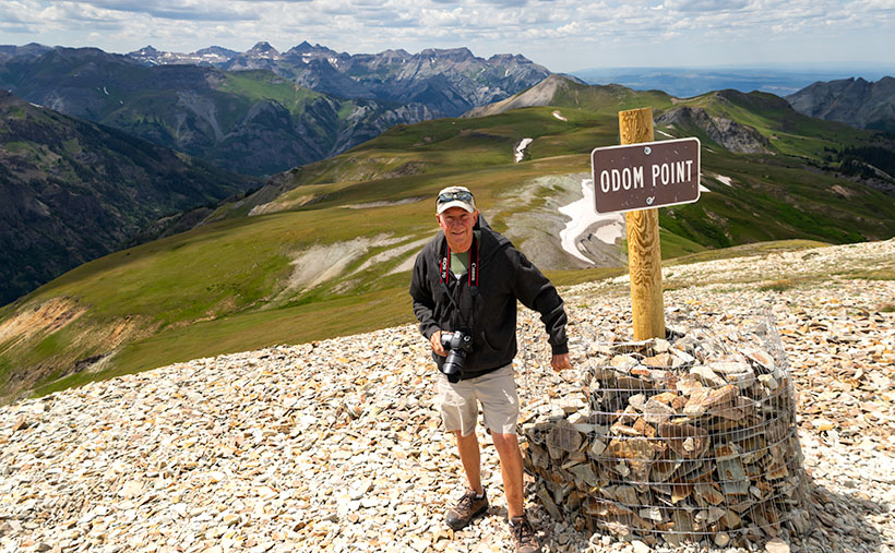
Mountain Man Fred – It’s not an illusion that Fred’s hanging on to that wire. The sign is well over the slope, and the footing is unsure because of the loose shale.

As we rounded a corner, we saw a knoll where several vehicles were parked, and a crowd snapping selfies and taking in the view. We assumed this was it. It wasn’t. It was Odom Point, and we joined the others for the view and document our visit. As we returned to the road, a sign that said that our pass was further down the road, so we drove another couple hundred yards.

Engineer Pass
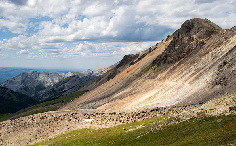
Engineer Pass – Looking north from the saddle, you can see two mule trails blazed by prospectors. One leads down into the valley while the other zig-zags up the unnamed peak.

This week’s image that I call Engineer Pass was taken from the 12,800-foot high mountain saddle looking north, and it shows an unnamed peak that’s another hundred feet higher. Also visible are two mule trails, one that descends into the valley and the other that cuts across the talus slope past the red streaks before a switchback as it zig-zags to the summit. I declined to try either of the trails.

While we were taking in the view, I turned around and was stunned to spot over a dozen cyclists peddling up the grade from Palmetto Gulch. No way! We were driving a jeep, and I was out of breath, while these guys were racing mountain bikes on the same road. It’s no wonder that Stephan Pastis ridicules bicyclists in his syndicated cartoon Pearls Before Swine. They’re insane.

You can see a larger version Engineer Pass on its Web Page by clicking here. Be sure to come back next week when we’ll continue exploring Colorado’s San Juan Mountains in Fred’s Toyota.

Until next time — jw

Cinnamon Pass Picture of the Week

So, I cheated on September’s subject. By that I mean that Archie and I didn’t drive on these roads, they weren’t just casual side roads—you had to want to go on them, and they weren’t even in Arizona. Let me explain, and I’m sure you’ll forgive me.

August is the time for our annual retreat from the heat. By then we’re in the middle of the muggy monsoon, and we have to find respite in a cooler place—even if it’s Utah. This time we decided to spend a couple of weeks with our friends, the Poteets. Fred and Deb have been working as camp hosts in Colorado and Minnesota for several years, so we dragged The Ritz to cool off in the 6500’ mountain air of Durango.

When we got there, the first thing Fred wanted to do was “… hop in my FJ and drive over some of Colorado’s famous mountain passes.” I thought he meant driving some highway over the Continental divide, but nooo. He was talking about driving the prospector roads in the San Juan Mountains. He bought the Toyota earlier this year and hadn’t yet put it through its paces. He swears the FJ badge on it stands for Fred’s Jeep, and he wanted someone to go and test it on what barely passes for roads. Now I know what Deb meant when she pulled me aside on arrival and said, “Tag, you’re it.”

Our adventure centered on the ghost town of Animas Forks, which is a dozen miles northeast of Silverton and at over 11,000’. We spent an entire afternoon driving over mountain passes that would look down on Mount Humphries—the highest mountain peak in Arizona. The so-called roads were one-lane gravel mule trails cut into the mountainsides. They had impossible grades, and often, the windshield view was just clouded sky. Many times the gravel was replaced with bedrock and the truck would tip precariously—always to my side, and I’d be looking in horror over the edge, and I’d quote something that Queen Anne has said many times to me, “<imagine a woman’s voice screaming>.” Then there were the switchbacks. “We’ll have to turn around,” I’d suggest in a high squeaky voice. Fred would answer with, “Here, let me put it in low range,” then he’d push some lever, and the FJ would claw its way further up the hill.

In all, we spent four or five hours above 12,000 feet and crossing four passes. When you’re at that altitude, a 13,000-foot mountain isn’t so much, so we’d get out and climb on foot to its summit for a pee. I’m glad that Fred remembered to set the brake because, with my luck, we’d be standing on a mountain top watching his truck roll backward into the valley three thousand feet below.

After we got back into Silverton, we stopped so Fred could put air back into the tires. “20 pounds is the minimum to keep the tire from separating from the wheel, but the ride is better.” He then asked if I’d like to do more mountain four-wheelin’. After thinking for a moment, and being the manly man that I am, I told him, “Only if I can bring a box of Depends along so I can change my shorts.”

Cinnamon Pass
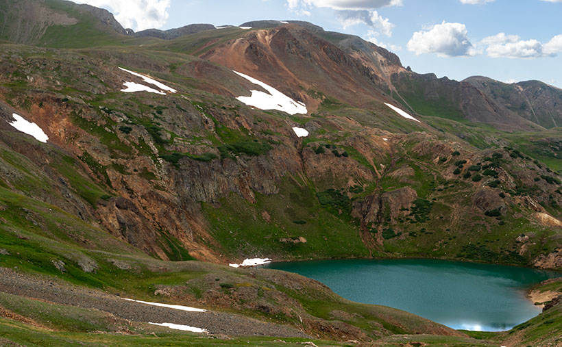
Cinnamon Pass crosses over the mountain of the same name at 12,640 ft. That’s well above the timberline in Colorado’s San Juan Mountains.

This week’s featured image was taken at the first of the four passes that we visited—Cinnamon Pass. When we got there, we got out, kicked at the dirt, and looked around with our hands in our pockets—it was cold up there. After shooting a couple of shots, I told Fred that I was going to climb up a roadside knoll to see if there was a better shot. On top, I found out there was because I saw the little alpine lake hidden from the road. As I hiked back down to the truck, I told Fred what I had found so he could see the pretty little lake.

You can see a larger version Cinnamon Pass on its Web Page by clicking here. Be sure to come back next week when we’ll show another photo from Fred and Jim’s exciting mountain outing.

Until next time — jw

Lightner Creek Fire

It was the Wednesday before July 4th and the Lightner Creek Campground and Cabins staff were making preparations for the busy weekend when our friends and fellow camp hosts – Tony and Amelia – raced into the park. This was unusual because the speed limit is 5 mph and camp hosts try to enforce it. They had just come back from town and breathlessly told us that there was a house on fire just east of the campgrounds. We all rushed up the park’s hill to gawk.

It was the house of our, shall we say, interesting neighbor. She lives there with her kids and they regularly shoot off fireworks and guns. On Memorial Day there were loud gun shots coming from there well into the night which made the campground guests nervous. Someone called the sheriff, but the shots stopped before they got there. One of her other neighbors said there were three loud explosions before the house caught fire. The house was burning very quickly and the color of the flames suggested that a gas fueled the flames. Rumors in the community said that she grew pot and processed something more potent in a back room, but we never verified any of that.

As we stood on the hill, we watched the fully engulfed house, when suddenly the fire jumped to the trees and started up the mountain. We all started panicking and using a lot of four letter words. Thank God the wind was blowing away from us.

Amelia – a 911 dispatcher in a previous life – asked if there was an evacuation plan. Robert and Andrea, the owners, fetched ours from office and contacted its creator – the original owner who lives alone at the campground’s west end. She came over, very upset and helped coördinate the evacuation. The plan broke the campgrounds into sections. The owners assigned camp hosts different sections and sent them to their assigned area with instructions for how each campsite should exit. We told everyone to “prepare to evacuate”. It couldn’t have been more than 15 minutes when we got a “MANDATORY EVACUATION” from Code Red – a must have cell phone app. No matter where you are in the USA, it will send you emergency alerts for your area. When the alert sounded, the camp hosts spread out to their assigned areas and began evacuating the campers. Several people were in Durango then, but we made sure anyone in the campgrounds knew they had to leave. After we got the guests out, Deb and I started to hook up our trailer, but before we could, a sheriff showed up in front of our rig and said we had to leave; NOW! So we started throwing stuff in the truck and car and abandoned the trailer. I had time to put in the awnings and turn off the propane, but that was it. A personal evacuation plan for our RV is on my to-do list from now on.

The fire quickly spread after jumping the road. Fortunately, the wind kept it away from the campgrounds.

The campground is in a box canyon and the only way out was down the road toward the fire. The wind was blowing the fire away from us, but it had jumped the road and started up Perins Peak to the north.  The fire had jumped across high enough that the road was not blocked. We drove through a maze of fire trucks but finally made it to Hwy 160. We assembled on the side of the highway and wondered what to do. We could see the smoke billowing out of the canyon and flames crawling up Perins Peak. We didn’t know if we would have anything to return to, but we got everyone out safely.

At The Rendevouz
After getting out of the canyon, we gathered at the sided of the road to ponder what to do next.

One of the guests in the group got word that the Red Cross was at the La Plata County Fairgrounds setting up an evacuation center. A seasoned camp host knew where it was, so most of us followed him. Wouldn’t you know it, the fairgrounds booked a rodeo for the holiday and the parking lot was full. Trailers and motorhomes were redirected to the high school parking lot next door. The next day the shelter moved to the Escalante Middle School which had a big parking lot for rigs. The Rocky Mountain Team Black Hotshot fire fighters moved into the fairground shelter. By the way, the Red Cross was great! They provided a place to sleep, water, snacks, and food – donated by various town restaurants.

Deb and I opted for a hotel room instead of trying to sleep in a dormitory full of kids, dogs, and people. When I got on the phone I found out that most of the hotels were booked for the big weekend. I finally found a room at the Holiday Inn, and we spent two nights there until they let us go retrieve our trailer. One at a time, a sheriff escorted the camp hosts in to hook up trailers then get out. The fire was only 20% contained so planes were flying over us while helicopters picked up water from trout ponds close to the road. Some idiot was flying a drone in restricted air space and delayed air operations a day (he was later found and he’s facing charges).

Lightner Creek Fire Damage
This is the ridge that the fire went up when it first started. The wind blew it over to the other side. This ridge goes right up behind the campground. The burn line runs along the ridge line and the only campground exit was down the canyon and past the fire.

It was a relief pulling our rig out of the park. We headed straight for the middle school parking lot where we dry camped for two nights. The Red Cross commandeered the dining room and they organized a big meeting on the fire’s fourth day with all the players; fire fighters, police, sheriffs, etc. who gave us the status of the fire. Denver TV stations filmed the meeting and we made the evening news. They told us that the fire was still only 20% contained, but they were letting some homeowners return to their homes. Since we were not home owners but were permanent summer residents, officials excepted the camp hosts and they issued us special Rapid Access ID cards. The next day they let us go back to the campgrounds. Whoopee! The road was still closed to the public and we couldn’t take any guests yet, but we were back in our summer home.

Fire Damage
This is where the fire started and continued over the top of the ridge toward Hwy 160. You can see how close the fire came to the campgrounds.

Since we had the campgrounds to ourselves, we threw a 4th of July Bar-B-Que. The campground wasn’t burned at all, and the facilities were fine. The fire came closer than we thought, but it did not cross the boundary. We were very lucky. There were a lot of cancellations for the 4th of July week, but we are now back up to full capacity and it is still a great place to spend the summer.

Fire Break
The morning we got our trailer out there was a line of fire fighters walking in single file to cut that fire line.

They have not identified the reason the house caught on fire, but it was very suspicious. Since the house was destroyed and the fire was so hot, the fire investigators couldn’t find the fire’s cause. As for our interesting neighbor … she wasn’t at home when the fire started, but she did check into the evacuation shelter, so she’s homeless but otherwise ok.

Fred Poteet

Mesa Verde National Park

After blowing all our money last year on the Alaska trip, Deb and I thought we were doomed to learning new survival skills for staying all summer in hot Arizona. Then our neighbor, Tom Beavert saved us. He spent his last five summers in cool Durango, Colorado and told us about jobs as camp hosts at the Lightner Creek Campground, so we checked in to it, and got the jobs.

We arrived in the middle of May, just in time for a little snow storm. This was a pleasant surprise after leaving AZ where it was already getting into the 90s. The campground is in a box canyon at 7000 feet elevation. That means the mornings are always cool (40s) and the afternoons are not that bad either (70s or 80s). We work 3 days on and 3 days off, so we have plenty sight-seeing time. It’s really nice staying here for the summer.

Google Map Durango Area
The map shows the highway between Durango, Colorado and Mesa Verde National Park.

Our first outing was to Mesa Verde National Park, about 35 miles west of Durango. We wanted to visit it before the hot summer set it. When we were dating, Deb and I had stayed in Cortez, CO and had stopped at the park, but only briefly. Hmm . . . I guess we had other things on our mind back then. This time as an old married couple, we saw everything. We spent 4 days in the park and took all the tours. There are a few self-guided tours and plenty of to do on your own, but the best ruins are only accessible via $5.00 guided tours, and because the tours fill quickly, you need to sign up early.

Cliff Palace
Cliff Palace, the crown jewel of Mesa Verde National Park and an architectural masterpiece by any standard, Cliff Palace is the largest cliff dwelling in North America.

Chapin Mesa is the main visitor center. It’s here you’ll find The Archaeological Museum, Cliff Palace (the largest cliff dwelling), Spruce Tree House, and Balcony House. The tours of Cliff Palace and Balcony House are a must. Balcony House is the most challenging tour. It starts with a climb up a 32 ft. ladder and ends with a crawl through a 12 ft. tunnel on your hands and knees. Believe me; it’s worth it. Allow a day to take both of these tours.

Long House
Long House, about equal in size to Cliff Palace, fills an expansive 298-foot-long sandstone alcove from end to end. The village includes about 150 rooms, 21 kivas, and a row of upper storage rooms.

Wetherill Mesa is the “quieter side” of Mesa Verde. It offers a number of opportunities, depending on the season. Mesa Verde is one of the few National Parks that allow bicycling, and on Wetherill Mesa there is a 5 mile loop built for a shuttle bus. The bus was discontinued, so now you can walk or ride your bike on a nice paved road. Wetherill Mesa was my favorite because it was less crowded and had one of the best tours.

Square Tower House
Square Tower House, a beautiful cliff dwelling built-in an alcove in the upper walls of Navajo Canyon. The “tower” had windows, doorways, and flooring, and the inner walls were plastered. About 60 of the original 80 rooms remain.

The Longhouse (the second largest cliff dwelling) tour takes 2 hours and you really get to explore all of it. Step House and Badger House are self-guided tours and you can ride your bike through the Badger House Community Trail. Allow one to two days to see everything on Wetherill Mesa.

Long House
Long House, a well-preserved four-story triangular tower rises from floor to ceiling at the far west end of the alcove.

Here is a tip for grabbing a good lunch. Far View Terrace is a nice cafeteria with a gift shop run by the Ute Indians. Their prices are good and the gift shop has a better choice than the Visitor Center. The only other place to eat on Chapin Mesa is Spruce Tree Terrace, near the museum. They are both good, but Far View Terrace is much larger and quieter. We had a wonderful Navajo Taco. If you are going to Wetherill Mesa, they only have a snack bar and a covered patio where you can eat your own lunch.

Far View
Far View was a popular place in the early days at Mesa Verde. From A.D. 900 to about 1300, it was one of the most densely populated parts of the mesa. Far View House in the background and Pipe Shrine House were part of the Far View Community.

Don’t forget to pickup the Amateur Photographer’s Guide at the Visitors Center. It is just one sheet, but it has some pretty good advice. It identifies the most photographed areas, the light at different times of day, and suggested locations for shooting. You need a telephoto lens for some overlook locations, but don’t wait for sundown to shoot from the overlooks. The best time is from 5:00 to 6:30 pm to get the most light on the cliff dwellings. Note that high contrast will overexpose parts of your picture and underexpose others. It is best to zoom in on either a dark or light area.

Petroglyph Point
Petroglyph Point Trail, An ancient loop trail starting at the Chapin Mesa Archaeological Museum leads to a petroglyph panel and through scenic wildlife habitat. Hikers must register at the trailhead or museum. The trail is physically challenging and is steep and uneven, with steps, cliff edges and tight passages, and includes strenuousness elevation changes.

We really enjoyed Mesa Verde and now it’s time to move on to our next adventure. We will be exploring downtown Durango and its surrounding area.

Fred