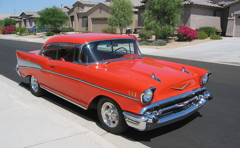
Holbrook Chronicles: A Quirky Journey Through Time and Asphalt Picture of the Month - Holbrook, Arizona

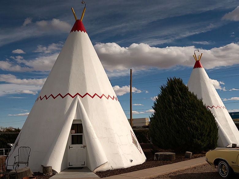
White tee pee-shaped motel rooms with classic car parked outside on Route 66 in Holbrook, Arizona
Nostalgic Nights: The Historic Tee Pee Motel of Route 66 – Step back in time with a glimpse of the historic TeePee Motel on Route 66 in Holbrook, Arizona—where classic cars and unique accommodations summon the spirit of America’s golden age of road travel.

Earlier this year, in a fit of cartographic embarrassment, I noticed my Arizona map was as barren in the northeast corner as my understanding of quantum physics. We use the map to bookmark locations we’ve visited and shared with you. “We must address this travesty,” I declared, or perhaps just thought loudly. Thus, Queen Anne and I embarked on an expedition to Holbrook, a place as famed for its petrified wood as my living room is for lost remote controls.

Upon our grand arrival in Holbrook, it became immediately clear how the town’s history was as layered as my attempt at a seven-layer dip, which never made it past layer three. From the ancient trading routes that seemed slightly busier than my last garage sale to the modern buzz of I-40, which promised the thrill of gas stations and fast food, Holbrook whispered tales of change. And by whispered, I mean it mumbled incoherently, much like Uncle Ray after his third Thanksgiving cocktail.
Wide-angle photo of playful dinosaur sculptures in a rock shop yard in Holbrook, Arizona, with petrified wood for sale
Petrified Pals: The Dinosaur Ambassadors of Holbrook’s Rock Shop – Encounter the past in a playful panorama with Holbrook’s roadside dinosaurs, a nod to the rich paleontological history unearthed at the nearby Petrified Forest National Park.

Diving into the town’s lore, we uncovered tales of early Pueblo peoples, whose idea of commuting was traipsing along the Little Colorado River. They traded goods with the enthusiasm I reserved for exchanging unwanted Christmas gifts. Picture them, settling down by the river’s edge, not to snap sunset selfies, but to swap stories of Coyote, the original trickster who probably invented the concept of “fake news,” and Spider-Woman, the ancient weaver who, unlike me, never blamed her tools for a botched job.

Then came the white men, striding into the horizon with all the subtlety of a brass band in a library. With their grand plans to connect coasts, Lieutenant Whipple and Edward Beale undoubtedly paused to ponder, “Will there be sufficient parking?” Their surveying tales were likely less about the awe of uncharted lands and more about the days when their socks stayed dry.

Early Settlement

In 1876, Mormons fleeing the excitement of Utah found solace in what would become Holbrook, a place that made their former home seem positively Las Vegas-esque in comparison. By then, the town had started to take shape, much like my attempt at sourdough during lockdown—full of hope but ultimately flat.

Our foray into this historical mosaic first led us to the part of town that had seen better days. “I’m not getting out of the car,” declared Queen Anne, with the determination of someone guarding the last slice of pizza. And who could blame her? The charm of the Arizona Rancho and the Bucket of Blood Saloon was as evident as the potential in my high school yearbook photo—present, but requiring a generous imagination.

Pedro Montaño built the Arizona Rancho home here between 1881 and 1883. It started as a single-story plastered adobe building with a high-pitched roof and dormer windows. After it was sold to the Higgins family, it became the Higgins House—a boarding house with a two-story addition. Next, it became the Brunswick Hotel. In the 30s, the west wing was used for Holbrook’s hospital, and during World War II, the Navy leased it to house pilots training at the airfield north of town. Now, it’s listed on the National Historic Registry and appears to be undergoing renovation.

Crossing the street from the train depot is another historic building in decay. It was initially called Terrell’s Cottage Saloon, and it was popular with cowboys and ruffians. After a violent gunfight in 1866 that ended up with two men dead, the street was described as if someone had poured a bucket of blood on it. The name stuck, and the saloon and street name bear the moniker. When we visited, a prominent sign urged people to contribute to saving The Bucket of Blood Saloon.

Imagine Holbrook as the Wild West’s version of a reality TV show, complete with outlaw gangs and cattle thieves vying for the title of Most Wanted, starring the Hashknife Gang and the Blevins Brothers, with special guest appearances by the Clantons, who thought the Earps’ version of justice was a tad too personal. Enter Sheriff Commodore Perry Owens, Holbrook’s answer to a sheriff who didn’t just wear a badge but practically invented the law enforcement genre with flair. His Wikipedia page? It’s the binge-worthy history lesson you never knew you needed.

Traffic Increases On Route 66
Faded green signage on an abandoned gas station under dramatic sky in Holbrook, Arizona
Deserted Drive-Up: The Withered Gas Station under Holbrook’s Sky – Behind a chain-link time capsule, the remains of what could be a Sinclair station stand sentinel under the vast skies of Holbrook, a mute testimony to the bustling days of Route 66.

Holbrook thrived on a cattle economy akin to a bovine social club for decades until 1926 rolled around with Route 66, flipping the script. Suddenly, Americans, intoxicated by the freedom of their Model Ts, were gallivanting across the country, pioneering the original road trip minus the luxury of air conditioning or reliable GPS. The Dust Bowl era added a gritty reality show twist, turning Route 66 into the “Mother Road” of all escape routes. By 1938, the road’s complete paving made cross-country jaunts less of a teeth-rattling affair, shifting Holbrook’s social scene north of the tracks. The town’s once-thriving pit stops turned into a ghostly strip of nostalgia, save for the Tee Pee Motel, now a restored relic where vintage cars outnumber guests—missing the chance to sleep in a concrete teepee? Now, that’s a modern regret.

Post Interstate 40

As Holbrook entered the fast lane of the Interstate 40 era, it seems the town, like a bewildered tortoise at a Formula 1 race, was sidelined by the rush towards efficiency. Where once adventurers might pause to marvel at the local color, they now zoom towards the neon glow of franchise signs, seduced by the siren call of combo meals and loyalty points. It’s as if America’s highways have become conveyor belts, whisking travelers from Point A to B with little regard for the stories and spectacles they blur past.

Amidst this homogenized landscape, Holbrook is a defiant reminder that sometimes the best part of the journey is the quirky diner you didn’t expect to love, not the time shaved off your ETA. In rediscovering Holbrook, we find not just a town but a treasure trove of tales begging us to slow down, look around, and maybe, just maybe, find a piece of ourselves among the echoes of Main Street. So, let’s take that exit ramp less traveled; who knows what stories await among the faded signs and whispers of yesteryear?
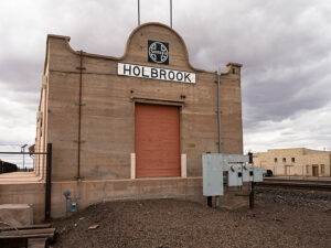
Old Holbrook train station sign with Santa Fe logo on a building repurposed as a warehouse along the railroad tracks
Tracks to the Past: Warehouse Days at Holbrook’s Old Depot—Standing with silent stories, the repurposed Holbrook train station along the SP tracks endures as a storied warehouse among the town’s architectural relics.

I hope you enjoyed our Holbrook tale and viewing the new photos. If Queen Anne and I have piqued your interest, you can see larger versions of this month’s adventure in my New Work collection <Link> and Fine Art America page <FAA Link>. They’ll be there for the next three months before they make way for a new adventure. Be sure to return next month when we stop at the Painted Desert and Petrified Forest.

Until our next detour, may your travels be full of discovery and stories as rich as Holbrook’s past.
jw

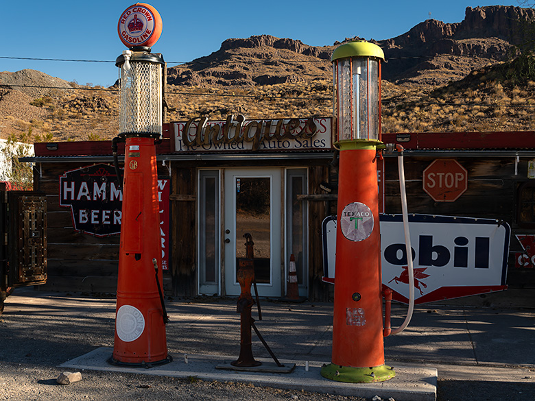
Vintage Red Crown Gas Pumps: Oatman’s Route 66 Treasures Pictrure of the Week - Oatman, Arizona

Vintage Red Crown gas pumps in Oatman, Arizona, along the famed Route 66, evoking the golden era of American road travel.
Time-Standing Still: Vintage Gas Pumps of Oatman – Step back in time with these meticulously preserved ‘Red Crown’ gasoline pumps, a vibrant reminder of Route 66’s golden era, now standing proudly outside Oatman’s antique store — a treasure trove awaiting its next collector.

Let’s talk about a little thing called ROI, or return on investment. In layperson’s terms, it’s like this: if your piggy bank’s diet consists more of withdrawals than deposits, it’s time to put that cash-chewing pastime on a strict no-spend regimen. It’s a handy rule of thumb for deciding whether that avocado toast obsession is a splurge too far and for the bigwigs running the corporate circus. They don’t just steer the company ship; they’re the jugglers, tightrope walkers, and lion tamers tasked with keeping the ROI roaring so the shareholders don’t start looking for a tamer’s head to put in the lion’s mouth.

In the harsh and unforgiving world of mining towns like Oatman, hitting the ROI redline means ‘game over’ for the local economy. The investors pack up their checkbooks, the mines shutter faster than a camera at a ghost sighting, and the workers scatter like tumbleweeds in a dust storm. The town’s pulse slows, and those left behind are like the band on the Titanic—playing on bravely, knowing the finale is nigh.

The tale of Oatman follows a script as predictable as the instructions on a shampoo bottle—minus the rejuvenating wash. It’s a cycle as old as time: boom, bust, and echo. The brightest stars eventually fizzle out, and Oatman’s star, once a beacon of the Gold Rush, was no exception. And just like a one-two punch in a heavyweight bout, Oatman’s knockout came swiftly. First, the mines dried up, and then Route 66 got a face-lift that sidestepped the town altogether. Modern progress, they said, but for Oatman, it was more like a step into obscurity.

The new road followed the railroad’s less adventurous path, leaving Oatman off the beaten path and out of the family vacation route. From the Clampetts to the Griswolds, no one was clamoring to visit an old shanty town at that time—and the Department of Transportation—forgot. Oatman became the town overlooking Mohave Valley with a ‘Do Not Disturb’ sign hung on its door.

As the rest of the world hurtled forward into the mid-20th century, Oatman seemed to hit the pause button. The once frenetic streets, echoing with the din of prosperity, fell silent, leaving only the whispering desert winds to tell their tales. For the few who chose to stay, life became a study of survival and simplicity. Oatman’s dwindling population, a patchwork of tenacious old-timers and resourceful souls, found a way to eke out a living from the sparse offerings of a town that had given its all to the golden days of yore.

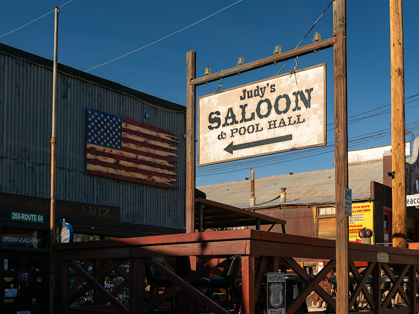
The rustic sign of Judy's Saloon and Pool Hall under a wall-mounted American flag on the historic Main Street of Oatman, Arizona.
Judy’s Saloon: Echoes of Oatman’s Vibrant Past – Under Oatman’s azure skies, the worn sign of Judy’s Saloon points the way, juxtaposed with a rustic American flag, to a place where the spirit of the West is not just remembered but still lives on.

The rhythm of life here was no longer dictated by the pulsing promise of gold but by the sun’s arc across the sky. The remaining residents turned to the land, coaxing modest gardens from the arid soil, trading with neighbors, and gathering at Judy’s Saloon for some, reliving the glory days in stories told and retold like cherished family heirlooms. They adapted, repurposing old mining tools for mundane tasks and transforming abandoned structures into homes and makeshift businesses that catered to the occasional traveler, lost or adventurous enough to stray from the new Route 66.

In this era, Oatman’s heartbeat was a subtle one, felt rather than heard, in the stoic persistence of its people and the silent dignity of its weathered buildings. The community’s fabric was tightly knit, each person a thread bound to the other by shared history and collective tenacity. Life in Oatman wasn’t about thriving; it was about enduring, about preserving the essence of a town too proud to fade away.

The gasoline pumps featured in this week’s picture tell a story that’s as much about progress as it is about preservation. Red Crown gas, a blend marketed by Standard Oil (now Chevron), was the fuel of choice during the era these pumps would have served. Picture this: classic cars now wear the badge of ‘vintage’ had a dial for drivers to adjust the timing advance. A tank full of high-octane Red Crown meant more zip without the dreaded engine knock. Nowadays, that’s a job delegated to the computers in our cars.

But take a closer look at these gravity-feed pumps. Their pristine condition raises a question—have they stood the test of time, or are they beautifully restored pieces of history? It’s a bit of a mystery, much like the stories they hold. And for my eagle-eyed followers, yes, you’ve already noticed the white roof of the Diner Car peeking out on the left.

I hope you enjoyed this stroll down the quieter lanes of Oatman’s history, but don’t pack away your walking shoes just yet. Next week, we’re dusting off the fairy tale books for Oatman’s own Cinderella story—a happy ending sure to sparkle. If your curiosity about those Red Crown pumps is ticking like a Geiger counter in a gold mine, here’s your treasure map: links to my web page < Jim’s Site> and the Fine Art America page <FAA Link>. And hey, if you find yourself meandering through Oatman in the next few months, pop into that antique store and snoop around for the price tag on those pumps. Don’t forget to spill the beans in the comments below—I think they’d make a lovely gate for the end of my driveway.

Till our next adventure, keep your spirits high and your humor dry.
jw

Techniques: Mastering the Art of Symmetrical Composition

This week’s photo ventures into symmetrical composition, a method that, admittedly, I usually give a wide berth. Symmetry in photography is all about balance, akin to placing two candles at either end of a mantle for that classic, mirror-image elegance. But who says rules can’t be bent for a bit of creative flair?

Regarding the Red Crown gas pumps, symmetry was the starting point, not the destination. I aimed to capture both pumps in a single frame, spaced evenly from the frame’s edges to create a sense of balance. However, I opted for a slight twist rather than a straight-on, textbook symmetric shot. By shifting my position to the right, the pumps became natural frames for the ‘Antiques’ sign in the background, adding layers and depth to the image. It’s like setting those candles at different heights on the mantle; it catches the eye, creates tension, and makes you look twice.

The result? A photo that adheres to symmetry principles while stepping out of the conventional bounds, making for a more intriguing and dynamic composition. Sometimes, bending the rules just a little can lead to a more compelling story being told through the lens. What’s your take on it? Traditional symmetry or a dash of asymmetrical intrigue?

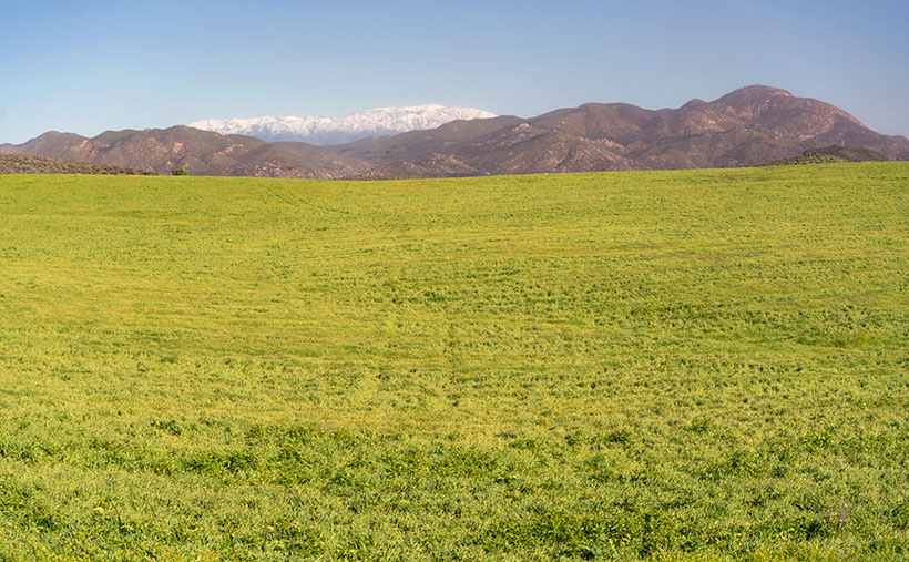
San Jacinto Field Temecula, California

San Jacinto Field - The snow covered San Jacinto Peak dominates the skyline near Temecula, California.
San Jacinto Field – The snow-covered San Jacinto Peak dominates the skyline near Temecula, California.

Long before I moved to Arizona—before my time in the Army—I used to enter rallies driving my 64 Ford Falcon. For my non-gearhead readers, a car rally is a competition where the hosting club plans a pleasant drive through the countryside. A driver’s job is to follow directions at a given speed and arrive at checkpoints on time. At the same time, the event chairperson purposefully writes the instructions as vague as possible for back roads that are impossible to drive at the speed they’re talking about. Each team is scored by how many seconds off you arrive at checkpoints behind schedule—if you can even stay on course.

I mention this because, in last week’s comments, our friend Gary brought up an “uphill-in-both-directions-in-the-snow” moment—in other words, his later recollections of Temecula Valley. It reminded me of the only previous time I visited the farms and fields of Riverside County was during one of these rallies.

In the October between high school graduation and joining the Army, we’d pilgrimage to the legendary Riverside International Raceway to attend the annual Can-Am race sponsored by the Los Angeles Times. In those days, Can-Am cars were the cutting edge of racing technology, having big brutish American engines shoehorned into tiny European chassis. I was an apostle. I didn’t know it then, but in 1969 Uncle Sam was reaching for my shirt collar, so my teenage days were numbered.

As that summer ended, I was already planning a long October weekend at the racetrack. The So-Cal Sports Car Club was staging a pre-race time-distance rally in Riverside, culminating with two laps around the track. I don’t remember why my usual navigator wasn’t available, but I recruited the older brother of one of my friends because he wanted to see the race and said he could read directions.

For brevity’s sake, all I will say about that event was that it started in the Shakey’s Pizza parking lot across the street from Riverside’s stunning Mission Inn on a cool, damp, and foggy Sunday morning. The course layout took us past Hemet, Moreno Valley, and Perris towns. We couldn’t see more than a thousand feet of road through the grey murk. We missed the mountains, fields, and trees dotting the countryside, but we did pass cherry stands that I was sure I’d return to someday. My navigator and I got hopelessly lost and behind schedule, so we threw in the towel and drove to the last known checkpoint with our tails between our legs. We rejoined the group at an infield staging area and thought, “At least we’d get a couple of timed laps around the track.”

You already know what’s next, don’t you? The laps weren’t time trials as I had imagined. It was a painful parade of rally drivers behind a slow pace car at 25 mph. Everyone was holding back to get a run at the turns by the second lap. The pack of cars looked like a hobbled caterpillar trying to make its way along a cherry tree branch. At the time, it was genuinely humiliating. I wanted to show Jim, Dan, Mark, Bruce, and Roger how good I was. Now, it’s amusing.

As Gary mentioned last week, that part of California is different now. The two-lane back roads we sped down are now eight-lane freeways with crowded off-ramps. The rural fruit stands have been replaced with Costco, CVS, LA Fitness, and car dealerships. The pristine mountain ridges are lined with rows of McMansions that look like pop-up targets at a rifle range. With clusters of boxy tract homes, Temecula Valley has become another typical So-Cal suburb.

Queen Anne and I spent time driving between housing developments during our January visit and saw a glimpse of the past. In this week’s photo, you can see the open spaces we found by Lake Skinner. In the shot that I call San Jacinto Field, the foreground is dominated by a field left fallow this season. In the near background, you see low-elevation mountains—Bachelor Mountain (2470) on the left and Black Mountain (3051) on the right. Covered in the snow in the far distance is San Jacinto Peak (10,834), which is over 50 miles as the crow flies. It’s much further if you walk. This photo was taken a month before California recently got slammed with two heavy snowfalls. I’m sure the top is even brighter white at this writing.

Wine Glasses - A sample of red and white wines while enjoying lunch at one of Temecula's Vineyards.
Wine Glasses – A sample of red and white wines while enjoying lunch at one of Temecula’s Vineyards.

Like always, you can see a larger version of San Jacinto Field on its web page by clicking here. Be sure to return next week when we drive up the wine-country valleys and visit some vineyards.

Till next time
jw

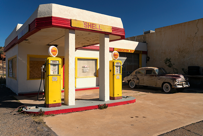
Shell Station Lowell Arizona

Shell Station - A small Shell gas station is located at the north end of Erie Street in Lowell, Arizona.
Shell Station – A small Shell gas station is located at the north end of Erie Street in Lowell, Arizona. The 51 Chevy parked out front was a nice touch. The pumps are priced at 41 cents per gallon if you’re interested.

Maybe I’m doing this wrong, but I’m a photographer first and a storyteller second. When I’m out taking pictures in the field, I don’t have a story in mind that I have to illustrate. My stories come after I’m at my desk trying to explain why I bothered to snap the shutter. Some weeks I struggle to put together two pages of sensible words; other times, my thoughts fly at my keyboard, and my fingers seem to move barely.

When Queen Anne and I happened upon Lowell and made our unplanned stop, I hopped out of the car and started snapping pictures down one side of Erie Street and up the other. When I returned home and processed the images, it was like there was a story in me begging to be told—and these were the perfect pictures to hang them. Like the rest of February, this week’s featured image, Shell Station—has a built-in untold story about my first real job.

I never got an allowance when I was in high school. My dad paid me to work at his drapery factory after school and on weekends. It should have been the perfect arrangement because I was mostly alone. I hated it because it was repetitive work, and it had nothing to do with cars or girls—besides, dad always thought I was goofing off—which I was.

The summer of my graduation, Dave—a good friend of mine—asked if I’d be interested in working evenings at his brother’s gas station. George—the owner—was short a person and needed someone dependable. I went for an interview, and George wanted me to start that very Saturday so that he could learn-me-up on how to pump gas. On Saturday, I was still in bed when the phone rang, and I vaguely remember driving to Van Nuys half dressed.

George’s station was an Atlantic-Richfield (ARCO now) on the northeast corner of Van Nuys and Magnolia Boulevards. It was about three times the size of the Shell Station in this week’s picture. He had three gas islands and two service bays, open 24 hours daily. My salary was only 1.65/hr, but because it was a service station, we got a commission on everything but gas. That’s why we were so happy to wash your windows (blades), check your oil (air filter), and your tire pressure (if you sold a set of tires, you were golden). Although it was common then, we didn’t pressure the customers to buy anything—we’d show them the evidence and let them decide. It worked for me, and I could make an extra $5.00 weekly.

There was another significant aspect of George’s station. I don’t know if you did this in your part of the country when you were a teenager, but cruising was extensive on the west coast. Every Friday night, pimpled face adolescents from across the valley would pile into shiny cars and drive up and down Van Nuys Boulevard. The guys paired up in someone’s hot rod, and the girls rode around in daddy’s T-Bird. Our traffic pattern started in Panorama City, south through Bob’s Big Boy, a turn around at Magnolia, and drove back to the beginning. There wasn’t any point to it other than to see and be seen (and it annoyed older people). If you need an example, run to Blockbuster Video and check out the movie American Graffitithat was us.

Our station was at the loop’s south end (less than a mile from Bob’s), and we’d have more traffic driving behind the gas station every Friday night than we did out front the rest of the week. Since we were convenient, the kids took advantage of our restrooms. From the horror stories I heard, I’m glad I wasn’t part of the Saturday morning crew that had to clean them.

As you’ve heard, everything shall pass, which also happened with George’s station. As property values rose in the San Fernando Valley, the gas station’s land was so expensive, Atlantic Richfield sold the land to a developer who built a high rise. George got an amicable settlement and a much smaller station in Reseda, which closed at 9:00 pm each day and didn’t open Sundays and holidays. I worked at that station until I got drafted. Besides getting my first drag racing ticket on my way home, I don’t have any interesting stories from there.

You can see a larger version of Shell Station on its Webpage by clicking here. This completes our February visit to Lowell, so we’ll move on next week. Come back and find out where the road led us—won’t you?

Till next time
jw

BTW:

Did you work at a gas station? How do you think they compare to the self-service ones we have today? Do you feel the cars get as much care as they need?

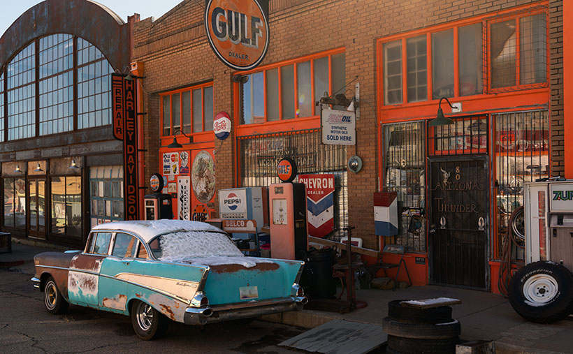
Bel Air at the Gulf Station Lowell, Arizona

Bel Air at the Gulf Station - a 1957 four door Chevy Bel Air waits for gas at the Gulf Station in Lowell, Arizona.
Bel Air at the Gulf Station – 1957 four door Chevy Bel Air waits for gas at the Gulf Station in Lowell, Arizona.

My lifelong love affair with cars runs so deep I’m sure I was born wearing aviator sunglasses and a pair of black Italian leather driving gloves—the kind with knuckle holes. My earliest memories are of toy cars from my parents, the countless scale model kits I built in my room, and the peddle car I had when we lived on the steepest hill in Pittsburg. At age five, I learned to drive it with my feet off the peddles so it could go faster. I held on for dear life and eventually got around the corner at the bottom without lifting (for the uninitiated, that means not scuffing your shoes along the sidewalk). Of course, even then, I complained about the dreaded push back up the hill.

My dad and Uncle Bunny (Yeah, that’s right. His real name was Charles, but everyone called him Bunny) came home one Saturday when I was thirteen with a beater 51 Ford sedan. It was less than ten years old but already considered junk. Dad proclaimed, “If you can fix it, you can have it.” He handed me a pair of pliers and a flathead screwdriver. I had no mechanical training and no idea what to do. After unsuccessfully trying to remove one of the head bolts from the old flathead V8, I gave up. The coupe sat silently in our garage for years.

I did find a use for it eventually. One day I was walking in our alley from school when I spotted a trash can overflowing with Playboy magazines. I don’t know who threw them out, but it was a gold mine for a 13-year-old. I scooped up as many as I could carry and stashed them in the back seat of my Ford when I got home. My little friends and I spent countless hours pouring over those articles until we wore out the magazine staples. I suppose that’s when my dirty old-man training began.

I guess that’s why I’m so delighted to find a place like Lowell and its open air museum showcasing things from my past. For example, when I look at this week’s picture—called Bel Air at the Gulf Station—I see the 57 Chevy and remember cruising through Bob’s Big Boy in a 58 Ford my cousin drove that dad bought us. Clydie would pull a couple of plug wires off, so it had a loping idle. It didn’t bother him that the car reeked of unburned fuel or that the guys with real hot rods were wise to his scam. It was Clydie’s moment in the sun. There are so many stories about that 58 and my cousin Clydie it would fill a whole chapter in my autobiography.

We never had Gulf or Sunoco gas stations on the west coast. Our premium gas was Chevron Supreme. I became a fan-boy when Gulf sponsored the winning Fords and Porches at Le Mans. If there were a Gulf station within a hundred miles of my house, I would have gone out of my way to fill my tank. Unfortunately, Gulf Oil merged with Standard oil in 1986, and their stations are now Chevron and don’t sponsor racecars. Maybe that’s why there is a Chevron sign on the orange building, which otherwise seems out of place.

I feel there are a couple of errors in this presentation. The first is that Chevrolet is a four-door, and no self respecting greaser would own a four-door. Even our friend Fred once owned a 2-door (maybe he’ll share a photo with us). However, 57 Chevy’s are the pinnacle year for collectors, and they have cherry-picked them off the market. I doubt that there are any more hiding in barns somewhere in America.

The other error is a Pepsi and 7Up machine, but not a Coca Cola box. Unless you lived in Utah, no one drank anything other than Coke. Long before In-N-Out, Bob’s had a gorilla menu, and you could order a Coke with a shot of vanilla or cherry flavor. I knew all of that hip stuff.

You can see a larger version of Bel Air at the Gulf Station on its Webpage by clicking here. There’s more to see along Erie Street, so don’t forget to come back next week for another story.

Till next time
jw

BTW:

There is a gold star waiting for the foreheads of anyone —except for Fred—who can tell where the gas went into a 1957 Chevrolet.

Lowell Theater Lowell, Arizona

Lowell Theater - A Chevy flatbed truck parked at the Lowell Theater in southern Arizona.
Lowell Theater – A Chevy flatbed truck is parked outside the Lowell Theater in southern Arizona.

It was already well past lunch as we drove up Highway 80. Queen Anne’s all too familiar whining had begun, “I only had one meal today.” We were heading to Bisbee’s Copper Queen Hotel, where we could satiate our hunger. As we approached the Lavender Pit, I noticed an old Shell gas station in my peripheral vision. When I looked in the mirror, I saw that—not only was it real, but an old car was parked outside. That was enough catnip for me to slow the Buick and make a U-turn across four lanes of traffic. Lunch could wait.

When I turned onto Erie Street, I was surprised to see an entire block of old buildings with vehicles of the same period parked out front. Was I on a movie set, or had I died and gone to some photographer’s idea of heaven? I decided it had to be the former because I still heard Anne’s food grumbling in my ear. I was further confused by a wall sign saying, “Welcome to Lowell, Arizona.” I turned to Anne and announced, “We’re not in Bisbee anymore.”

Lowell is to Bisbee as Tempe is to Phoenix—a cling-on. Bisbee and Lowell were founded in the late 1800s as mining claims—Bisbee in the 1870s and Lowell in 1899. As the mines grew, they needed men to work them. Like every other mining town, the population lived first in tents, shacks, and finally, proper homes. Unlike the Tombstone mine, the ore at the Copper Queen Mine and Lowell Mine was so abundant that it supported the towns for over fifty years. That’s why these southern Arizona towns have masonry buildings instead of the rickety shanties of most ghost towns. Bisbee reminds me of the coal-mine towns in Pennsylvania or West Virginia.

As time passed, the Copper Queen (and Phelps Dodge) took over the operation of the Lowell Company. Underground mines are inherently dangerous, and there was so much copper ore still buried there that during the World Wars, it became economically feasible to build giant machines to scrape away mountains and dig big pits to extract the copper. Bisbee’s renowned scab in the ground is called the Lavender Pit—named for Harrison Horton Lavender (the mine superintendent). As the abyss grew, it took parts of Lowell with it. All that remains of Lowell today is Erie Street which runs from the traffic circle in the south and the pit’s edge on the north side.

Lavender Pit - The famous Lavender Pit mine where tons of copper ore was dug from the ground. The pit is so vast I couldn't fit it all in the frame, even with my wide angle lens.
Lavender Pit – The famous Lavender Pit mine where Phelps-Dodge dug tons of copper ore from the ground. The pit is so vast I couldn’t fit it all in the frame, even with my wide-angle lens.

A group of volunteers banded together and formed the Lowell Americana Project. They worked hard to restore and enhance the quarter-mile street and transform it into an open-air museum. Their hard work got them international attention for their cultural preservation. They have turned Erie street into one of the most photographed streets in the West. Like me, you’ve probably seen some of those pictures in magazines and films without knowing the location.

We’ll explore Lowell’s Erie Street in February, hopefully, to delight my car friends. I consider this week’s photo the foundation shot. It was taken at the north-end parking lot where I left Anne to starve while I skipped up and down the street taking pictures. In this shot, I wanted to show the theater marquee, the Gulf, and the Lowell welcome sign. As an additional no-extra-cost bonus, the town thru in a Chevrolet flatbed truck. I don’t know what year it is, so perhaps one of you gearheads can tell us. I also have no idea about the flying saucers. I didn’t find a reference to any abductions in the area, although more aliens visit Arizona than any other place. They like the weather here—especially at Bisbee’s mile-high altitude. Maybe the spaceships are a warning that you’re about to enter The Twilight Zone.

You can see a larger version of Lowell Theater on its Webpage by clicking here. We’ll begin our walk down Erie Street next week to see what we can find. Be sure to come back then.

Till next time
jw

BTW:

No Queen Annes were harmed in the making of this article. She finally got her lunch and a glass of wine before she fell asleep as we drove back to the motel.

Motel Downtowner Picture of the Week

Motel Downtowner - The 1930's sign was built on a tower to lure tourists off of Route 66.
Motel Downtowner – Nackard built the 1930’s sign on a tower to lure tourists off Route 66.

Tourism is Flagstaff’s biggest money maker. According to one ASU study, tourism accounts for 84% of the town’s employment. Some of our non-Zonie friends may wonder what the attraction is; most out-of-state people don’t know much about our state and can only name two Arizona cities. Every season has a reason to visit the town at the bottom of the mountains. As I said at the beginning of this project, its 6,909-foot elevation (1,600 feet higher than Denver), mild weather is an excuse for valley lowlifes to visit and escape the heat. Fall ushers in colorful aspen trees that the annual fires haven’t burnt—both of them. Then, in winter, some people like to strap planks to their feet and slide down the big hill out of town. Finally, everybody goes to Flagstaff to toast marshmallows during the spring fires.

In the above list, I didn’t mention the daily traffic on Beal’s Road—Route 66—now Interstate 40. It’s an excellent place to stop for a meal or to get some sleep. And—oh yeah, I forgot—it’s how you get to the Grand Canyon.

It’s no wonder overnight lodging shaped and dominated Flagstaff architecture—from abandoned stone ruins to tacky Route 66 motels to today’s boring corporate three-story shoeboxes lining I-40. I think it’s understandable but sad that, as highways evolve, the old buildings and signs are disappearing. I get a big grin when I see one standing and add it to my collection. It must be the same thrill a hunter gets when shooting a Moose, Elk, or Kiwanis.

Apartment House - I shot this down the street from the Downtowner sign. I'm positive that if my wife ever set foot in this building, it would rip a hole in the space-time continuum.
Apartment House – I shot this down the street from the Downtowner sign. I’m positive that if my wife ever set foot in this building, it would rip a hole in the space-time continuum.

Last week, I wrote about Du Beau’s novelty concept—lodging catering to the motor car traveler. His motel was the second of its kind in the country—the first was in San Louis Obispo, California (that one burnt down, which makes Du Beau’s the oldest survivor). The buildings in this week’s image are ten years older but were initially used for other purposes. According to one account, it was a brothel. How scandalous. There were whore houses in the west—who knew? It wasn’t until the 1930s that K. J. Nackard bought the place and turned it into a motel. At the time of its opening, the main road through town was on the south side of the tracks. Later, the highway department realigned Route 66 to the north side. That’s when the sign wars began.

If you’re fishing for customers and they drive by your door, you can hook customers on a bamboo pole, but when the traffic is on the far side of the train station, it’s time to break out the surfcasting tackle. Both motels began building bigger and brighter signs to lure travelers to the Bohemian side of Flagstaff. These signs make today’s city planners shudder.

I took this week’s photo, which I call Motel Downtowner, with the rising sun. I had been walking around town in the twilight, and the tower was one of the last places I shot. It was after 7:00 by then, and I needed a cup of coffee (Macy’s European Coffeehouse—he’s also a fellow photographer). I have tried to get a shot of this tower for years, but I’ve never been happy with my results.

Ford GT40 - Evidently, not all residents at the Motel Downtowner are lowlifes. I found this car parked in the motel's portico, and is rare, even for Route 66.
Ford GT40 – Evidently, not all residents at the Motel Downtowner are lowlifes. I found this car parked at the motel’s entrance ten years ago, and it is rare, even for Route 66.

You’ll notice that the characters are angled to be readable while driving the Mother Road, and that angle points to Route 66. The motel is no longer open. Another type of business has taken over the buildings, but the sign remains; somebody in Flagstaff appreciates good kitsch and history as much as I do.

You can view my Motel Downtowner web version on its page by clicking here. Next week, we have another historic Flagstaff hotel sign to show, so be sure to join us then.

Till next time
Jw

BTW:

Oh, you’re still here even though the show is over. You must read to the end of the article. Good on you, mate. You’re probably wondering what’s down here in the basement. This is my new ongoing section with announcements, follow-ups, answers, etc. I intend it to be a paragraph long (my fingers are numb) so I don’t have to clutter your inbox with extra mailings. I hope you find it helpful.