Stanton—The Outlaw Ghost Town Under Yavapai Skies

My lovely bride abandoned me for a couple of days to get her annual check-up at a beauty spa on the Arizona Rivera—Lake Havasu City. Before she climbed into her friend—Yasmeen’s—car, she turned to me and with a pointed finger and sternly said, “I have two words for you. Be – have!” Well … that sounded like a challenge to me, so I began thinking about what kind of trouble I could get into. I was in the mood for a photography outing and I hadn’t been to Stanton since Fred and I got lost, so I tossed my gear into the truck and set off to get some new photos.

Hotel Stanton
Hotel Stanton – During the Summer of Love, hippies moved in and set up a commune. Unfortunately, they tore down many of the old buildings for firewood. LDMA has slowly repaired the remaining structures since acquiring the town in 1976.

Stanton is one of the many towns in mountainous Yavapai County (rhymes with have-a-pie) where, because someone discovered gold, a town sprung up overnight and disappeared just as quickly when the ore played out. It was little more than a stagecoach stop on the Wickenburg-Prescott road at  Antelope Creek until a tracker named Alvaro chased an errant burro to the top of what is now Rich Hill. When he got back to camp and told the expedition leader—Pauline Weaver—about finding gold nuggets “the size of potatoes” on the summit, you can surely guess what happened next.

Opera House
Opera House – The Opera House is an adobe building with a brick façade. It’s now used as a meeting hall for the RV Park.

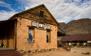
The town—known at the time as Antelope Station—got its name from an unscrupulous character named Chuck Stanton who moved to the thriving community several years later. Stanton opened a store and, with the help of his hired banditos, killed off his competition. His reign didn’t last very long as he was shot and killed that same year (living with swords, I guess). The town thrived afterward for several decades but it had a bad reputation. “In 1892, for example, a Prescott newspaper reported that the residents of Stanton liked to ‘drink blood, eat fried rattlesnakes and fight mountain lions’” (Wikipedia). By 1905 the gold ran out and Stanton was abandoned.

Stanton Homes
Stanton Homes – Only three houses have survived the years of abandonment. They line a street surrounded by campers.

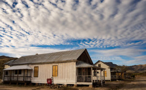
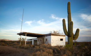
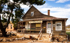
Ownership has changed several times since then and now it belongs to Lost Dutchman’s Mining Association (LMDA) and they have turned it into a member’s only RV Park. Membership is kind of pricey but LDMA has methodically bought up mining claims in the area and its members can work those old claims without charge. It’s surprising how many people will pay good money to play in the dirt—I don’t even like to plant flowers. Guests are allowed to visit but they first have to stop by the office and sign a release.

After my visit this week, I drove further down the road to the old Octave and Weaver mine sites and saw people on either side of the road prospecting. Late in the day, I stopped to take a photo along the roadside at quitting time when several trucks pulled out of a side road. They all slowed and waved and one of the men stopped to ask if I was getting some good shots. I asked him how his day went.

“What do you mean?” he asked.

“Did you make a fortune today,” I explained.

He laughed and replied, “Only the boss makes any money.”

“I see.”

Then he started telling an old joke, “Do you know how to make a small fortune in placer mining?”

“Yeah, you start with a big fortune,” I responded.

With that, he laughed and drove off in a big trail of dust.

Until next time — jw

Saguaro Station Picture of the Week

This week’s new photograph wasn’t taken in Aguila for a change. I took it on the way home from my outing there. This is the second version I’ve taken of an abandoned service station at the Arizona Route 71 and US Highway 93 intersection. My first shot of this place—called Station 71—was before sunrise in November 2015. When I stopped this time, the sun was setting and I thought the stately saguaro added to the story of this old building. This version—called Saguaro Station—can be seen on my Website here.

Saguaro Station
Saguaro Station – An abandoned service station in the late afternoon sun along US 93 near Congress, Arizona.

I actually travel through this intersection often, and when I do, I try to stop and look for new angles. Usually, the light isn’t right or nothing interesting jumps out, but this day the beautiful light on the building’s graffiti-covered end-wall forced me to drag the tripod out of the car. The failing light also shows off the saguaro’s pleats.

The next time I stop, I should try to find what gas station brand this was. The gas signs are gone—no doubt scavenged by collectors—but maybe there’s a clue hidden inside the building among the tarantulas and rattlesnakes. In the next couple of years, this intersection going to be an exit for the new Interstate 11—replacing US 93 for traffic between Phoenix and Las Vegas. City planners expect the new highway to bring growth to this area and there’s talk of a Wal-Mart planned for this intersection. Ironically, that traffic would support a new gas station in this spot.

I hope you enjoy seeing this new photo and let me know what you think in the comments. Which version do you prefer? If you enjoy this post, please click the like button below.

Until next time—jw

Black Butte Picture of the Week

The Vulture Mountains are a twenty-nine-mile long collection of volcanic hills south of Wickenburg. The Hassayampa River runs along the range’s eastern boundary and the mountains taper off to the west. From our Congress home, two peaks rise out of the low mounds on our southern horizon: Vulture Peak’s rounded knob is to the left and the sloping top of Black Butte is on the right. Reminding me of a doorstop or a fallen cake, Black Butte is the subject of this week’s photo.

Black Butte
Black Butte – With its distinctive sloping top, Black Butte marks the western boundary of the Vulture Mountain Range.

The slanting top of Black Butte first caught my attention while I was still working. I drove the forty mile trip from Wintersburg to Congress on the Vulture Mine Road and the butte marked the place where the road turns north. I thought that its shape was the kind of thing you’d see in old western movie backgrounds. I knew that I would use it as a subject some time. A couple of weeks ago while I was shooting in Aguila, there it was waiting for me bathed in late afternoon light.

You can see the larger version on my Website by clicking Here. I hope you enjoy viewing it and I’d love to hear your comments below.

Until next time — jw

Eagle Eye Picture of the Week

We’re still hanging in Aguila for the new Photo of the Week. Although I drove twenty-five miles to the little town because I had wanted to shoot a specific sign, I then poked around town to see what else I could photograph, and I found the number one reason—if there is such a thing—to visit Aguila. Here’s my shot of the natural window in the hills south of town formed by eagle-head-shaped rocks. Aguila is the Spanish word for eagle; hence, you have the town’s name source.

Eagle Eye Window
Eagle Eye Window – Rocks form this window in the shape of an eagle’s head and is in the hills south of Aguila, Arizona.

I’m sure there’s a way to climb up to the window because I’ve seen people there. I didn’t take the time to find a way on this trip, but I saw on Google Maps that there was a trail from the cemetery south of town. As I said last week, there is a good view from the window along US Highway 60 by the working fields of Centennial Ranches. Even a moderate telephoto lens will bring the Eagle Eye closer.

I followed dirt roads between the fields to get closer for this shot. They had street signs, so I assumed the roads were public. It was late in the afternoon when I snapped this, and the beautiful streaky clouds were beginning to get color. I should have waited for sunset, but I wanted to get to another scene that I saw along the trip (which was a bust). You can see the larger version on my Website – Here. I hope you enjoy viewing it. Please let me know what you think by leaving a comment below.

Till next time — jw

Motel Aguila Photo of the Week

Motel Aguila
Motel Aguila – A faded sign marks the location of a motel on US 60 in Aguila Arizona.

This week’s new picture I call Motel Aguila, and it’s another faded motel sign for my collection. Located as you would expect, in Aguila—a farming town some twenty miles west of Wickenburg. It’s also across the street from last week’s shot, which is how I spotted it. The paint on this sign is so faded that I don’t see a business name, and there’s only a whisper of letters left to show it as a motel.

As the sign suggests, there is no longer a functioning motel here. The buildings seem to be converted to apartments sheltering migrant farm workers. With less than a thousand permanent residents, there aren’t enough people to work the melon and lettuce fields surrounding the hamlet. The workers have to sleep somewhere and I suppose an old motel is better than the improvised lean-to sheds I’ve seen elsewhere.

Aguila isn’t a destination. There’s a café, gas station, a Dollar General store, and that’s about all. In 1973, Interstate 10 diverted traffic twenty-five miles south, so there isn’t a motel to stay at even if you wanted to. Besides, the only thing to see here is the eagle-eye window in the hills south of town and that’s a fifteen-minute investment along the side of the road (I’ll talk more about the eagle-eye next week).

You can see the larger version on here on my website. I hope you enjoy viewing it and tell me what you think.

Till next time—jw