Everywhere I look, the desert is yellow, and it’s as thick as a jungle out there. When Queen Anne and I run into town, the train tracks—only a block from the road—are hidden behind the dense foliage. I supposed this was predictable with the good rains we had this winter. We had a good crop of poppies this month along with purple lupine and orange mallow lining the highways.
Several plants give to the yellow with the first to bloom is the Brittlebush. Their soft yellow flowers look like small pale yellow daisies on stems rising from sage-green leaves. Unlike the poppies, their color isn’t vibrant, but they’re so pervasive that they’ll turn mountainsides yellow. They thrive in disturbed soil, like the highway shoulders.
Creosote bush adds a second note of yellow. The lowly creosote is like the lawn of the desert, except it grows 4-6 feet high. A couple of weeks ago, the field across from the park was Kelly green. The bush’s flower is small—almost like buds, and now that they’ve popped, the green has a golden tint.
The yellow crescendo comes when the Palo Verde bloom. Last week, Her Majesty and I ran down to our dentist at the border, and along the way, the trees were already blooming in the low-lands. The bloom moves through the desert like an opening curtain into the highlands. Today I see the trees in our park are beginning to show the tiny flowers. At their peak, the Palo Verde dot the mountainsides with yellow splotches. It’s then you realize that they’re growing everywhere. There’s a color symphony, and quail provide the background music with calls as they stake out their territory. It’s the best time to live in the Sonoran Desert.
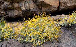
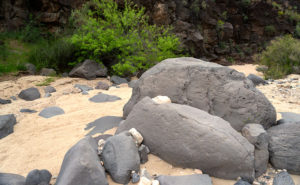
When Fred and I were out taking photos in Black Canyon a couple of weeks ago, I saw lots of brittlebush growing in the lava rock cracks. Their soft yellow popped against the dark, almost black canyon walls. Since they screamed, “Spring,” I wanted to capture the contrast. Out of the several shots that I took, I liked this week’s image best.
In the shot that I call Lava Tube and Brittlebush, three plants were growing below a gaping void in the rocks. I believe it’s a tunnel that formed when the molten magma lost pressure then receded. It’s just like when you were little, and your older brother tortured you by pinning you to the floor then drooled over your face but sucked the spit back at the last moment. The threat was always worse than the spit. Oh! By the way, on your first desert visit, inevitably someone will tell you, “Don’t sick your hand into any place you can’t see.” The lava tube is an excellent example of what they mean. I tried to get Fred to see if he could find any rattlers in there, but he refused. He was no fun at all.
Oh, if you’re wondering how brittlebush got the name, here’s an example of how they look after a couple of weeks without water.
You can see a larger version of Lava Tube and Brittle Bush on its Web Page by clicking here. I hope you enjoy viewing this week’s post and next week; we’ll show another featured image from a different Arizona site.
Until next time — jw