Mobil Antlers Picture of the Week

A long time before we moved here, I remember driving through our little hamlet and noticing the old buildings in town. Queen Anne and I were traveling to visit my folks in Kingman, and after leaving Wickenburg, traffic stopped. Thinking it must be a result of an accident, I said to Anne, “We can detour around it by going to Congress.” It was ten miles out-of-the-way, but at least we’d be moving. It was when we reached the village that I saw the structures and said to her, “That’s so cool. I don’t remember this being a ghost town. I’ll have to come back and photograph it, someday.” (As an aside, my detour didn’t work because the accident was further north on US 93. We finally drove over to the river and took US 95, which put us several hours behind.)

There’s a reason why I didn’t remember those old buildings even though I had gone that way several times before. They weren’t there. After moving to Congress, that someday that I had set aside to photograph Congress’s historic district finally came. When I did, it disappointed me to learn that they’re a fake, like a back-lot movie set. The buildings are empty shells apparently used to display someone’s antique sign collection, but I don’t know why. It’s like someone threw up some structures as a tourist attraction and then quit before finishing.

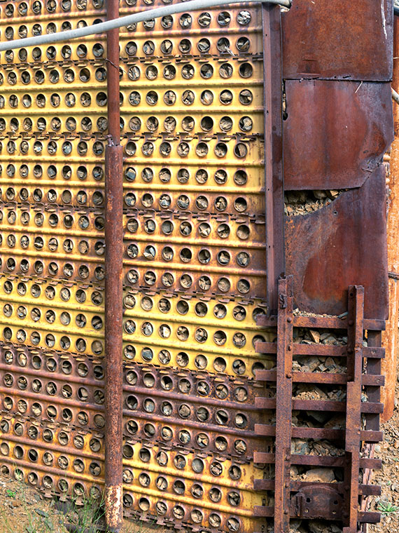
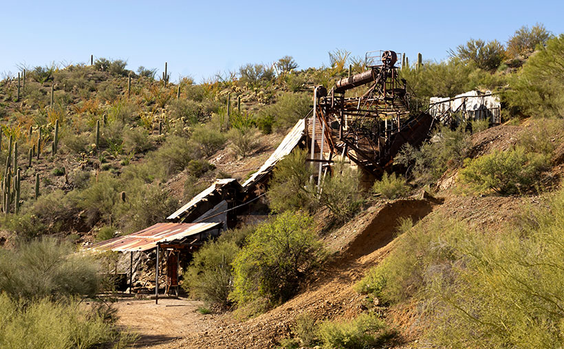
The area of town at the  AZ 89 and AZ 71 junction isn’t the historic part of Congress. It used to be called Congress Junction or Congress Depot. The historical part of town was up Ghost Town Road near the mine. In this Wikipedia article, there’s a 1914 photograph that shows how it was. When the mine closed in the 1930s, the town moved to today’s location—lock, stock, and barrel. All of the buildings in the photo are gone. The land was scraped clean, including the mine structures. The only thing remaining is the old cemetery and a shed for Stephan—the mine’s caretaker.

Wouldn’t it be nice if someone bought and moved these buildings along the railroad tracks from old town? I don’t know, because there’s nothing to explain their existence. The only remaining business there is someone selling landscape rocks. Maybe you know the story and can share it with us, or perhaps, when I get a ’round-to-it,’ I’ll investigate and post an update.

Mobil Antlers
Mobil Antlers – An antique Mobil Oil flying horse is displayed over a pair of antlers at Congress’s fake garage.

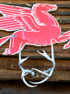
I’ve pretty much ignored this part of town for the past three years, but since we’re featuring Congress during March, I wanted to show you what always catches my eye as I drive by them. It’s the Mobil Oil red flying horse sign. I’d like to have something like it to hang on the gable over my garage door—perhaps a Ferrari, Porsche, or one from Sunoco. To be accurate, however, my sign would be for beat-up Chevy station wagons.

In this week’s featured picture that I call Mobil Antlers, a set of antlers upstage the flying horse, so I concocted a fantastic story about it. It represents a tale about a red horse that soars high in the sky. He spots his prey in the meadow below—a handsome buck. The horse swoops in for the kill, and there’s a mighty struggle with the deer attempting to gore the soft underbelly of its attacker. Red-horse prevails and devours Bambi except for the antlers because they’re indigestible. Then I thought, nah—I’m not going to say that—it’s just too bizarre, and people will think I’m weird.

You can see a larger version of Mobil Antlers on its Web Page by clicking here. I hope you enjoy viewing this week’s image and come back next week when we’ll talk more about Congress.

Until next time — jw

Retaining Wall

There are hundreds—if not thousands—of abandoned towns and mines in Arizona. Most of them don’t have much to offer, because all of the things of interest have been taken away. As I pointed out in last week’s post about Anderson Mill, the good stuff has already been salvaged. In Arizona, there are about ten ghost towns, like Jerome, Bisbee, and Oatman where the residents were able to transform their community into a tourist destination, but the majority of them have returned to nature, and you’re lucky to find a concrete slab.

Retaining Wall - A retaining wall at the Anderson Mill made from surplus Army landing pads and steel plate.
Retaining Wall – A retaining wall at the Anderson Mill made from surplus Army landing pads and steel plate.

 Last week’s adventure to Anderson Mills is an example of my point. I would have been delighted if the sheds, trucks and other equipment remained on site. Alas, that’s not the case. At least the main-processing structure was still standing, probably because it was welded together and pirates couldn’t easily strip them. From what was left, I even got an idea of how the Anderson brothers cobbled together the plant with scrounged parts and probably no plans. My dad worked like that. He figured it out in his head and would slap things together. I should ask Fred—who’s a certified nuclear welding inspector—what he thought of the fabrication.

As I was shooting, I looked for strong elements of design; colors, patterns,lines—that sort of thing. As we were ready to make the trip home, I didn’t havemuch time to spend behind the camera. The most color that caught my eye rightaway was a retaining wall, built out of Army landing pads. The mica processingplant is gravity feed and sits maybe 50 feet above the bed of the wash. To makea level base up there, the Andersonsbuilt a reinforced embankment wall out of panels and then back-filled it withrubble.

When I took this picture of the week, I focused on the panels that had alternating yellow color values. I like that against the rusty steel corner plates. However, I didn’t notice the narrow gauge mine-car tracks holding the bottom together. It seems like an expensive piece of scrap metal compared with the other building materials used. I like the abstract feeling of this image, and I call it Retaining Wall. 

You can see a larger version of Retaining Wall on its Web Page by clicking here. I hope you enjoy viewing this week’s post and come back next week when we’ll show another featured image from San Domingo Wash.

Until next time — jw

Water Pump Gears Picture of the Week

Once again the page on my calendar has changed, and I need to find a new site in the county to photograph. I spent all last week pouring over my maps that I had spread across the dining room table looking for an exciting candidate. I wanted to avoid the Christmas decorations towns put up during the holidays, so I was resigned to someplace rural. Then—on Monday—during my morning bike ride, I passed the Poteets who were out for a morning stroll. As I passed by, he shouted out an offer to ride in Fred’s fabulous four-wheel flier. The park’s off-road group planned an outing to Anderson Mill. I didn’t know what that was, so when I got home, I looked it up, and behold, it was in Yavapai County—only by a mile, but it still counts, and that meant the trip would kill one stone with two birds. I immediately sent him an email accepting his invitation.

Anderson Mill
Anderson Mill – A World War II-era mine and mill that produced mica for electrical insulators.

Before I talk about the mill, let me explain the trip. The off-road group is a bunch of friendly people who have all-terrain vehicles (ATVs) or rock-crawling Jeeps, and they go on regular outings to places of interest to drive their toys. It’s the trip and not the destination that’s important; the more circuitous the route, the better. We spent all day driving to a place that’s only a half hour away if you go by the highway into Wickenburg. They drove down the washes and trails where Fred and I got lost a couple of years ago, and they did it on purpose. They relish getting dusty; something they feel is a feature and not an off-road nuisance. The dust was terrible when Fred and I went out alone, but this time we followed a half-dozen other ATVs. When I walked into the house that evening and brushed the dust off, it looked exactly like in this YouTube clip from the new Cohen Brothers Netflix movie The Ballad of Buster Scruggs (Another masterpiece. Try to imagine Gene Autry meets the Twilight Zone).

Meanwhile, back at the mill …

Water Pump Gears
Water Pump Gears – The gears of the Anderson Mill water pump located north of Wickenburg.

Anderson Mill was a homestead claim run by Sid Anderson and his brother (documents don’t show the brother’s name) during the World War II period. They mined and processed mica—a mineral useful for electrical insulation and drywall joint compound among other things. The mine and mill are located in the San Domingo Wash north of Wickenburg and was productive until 1951—when plastics became a cheaper substitute. The mill’s ruins consist of welded panels and stairs topped by a rotating tumbler that—oddly enough—still has the original drive belt. As you would expect, pirates have already salvaged all the working motors and engines.

This week’s featured image is from a pump that pushed water up to the tumbler. The smaller gear drove the large one, which eventually cycled a piston pump. A Hit-and-Miss engine probably powered the whole Rube Goldberg setup. The things that compelled me to take this image are the relationship of the gears, the radial pattern of the spokes, the mass of iron bolted to an I-beam, and the beautiful rust patina. I gave the photograph the simple name of Water Pump Gears.

You can see a larger version of Water Pump Gears on its Web Page by clicking here. I hope you enjoy viewing this week’s post and come back next week when we’ll show another featured image from San Domingo Wash.

Until next time — jw

Swilling Cabin Window Picture of the Week

This week’s story has all the ingredients of a great Hollywood Western movie: plantations, young love, war, drugs and alcohol, heartbreak, gold, bright futures, despair, stage robbery, friendship, false accusations, and tragic death. I don’t know how to tell it all in 500 words and still explain my weekly photograph in the third paragraph. I’ve found several books and articles about Jack Swilling, but there haven’t been any films. That’s a shame because I can visualize it like the Steve McQueen movie Tom Horn.

Swilling Cabin Window
Swilling Cabin Window—Jack and Trinidad’s cabin ruins in Black Canyon City are on private property, and their caring owners are their only protection.

Every school kid in Phoenix knows how Jack Swilling—or one of his friends and crew, Phillip Duppa—tossed out the mythical bird’s name for the small town they were developing. Swilling filed a land claim around present-day 32nd Street and Van Buren Road for the rest of you. He wanted to grow hay to sell to the cavalry at Fort McDowell, so he copied the Hohokam method of using Salt River water for the fields by digging new canals to his property. The visionary Swilling (I suggest casting a 20-year-old Jeff Bridges) played an essential role in the layout and alignment of the new town. A couple of years later, he lost interest when the council—or whoever decided those things—moved downtown three miles west to its present site. Jack threw his hand up in disgust, and he and his wife, Trinidad (my casting idea would be a 17-year-old Natalie Wood), moved to Gillett—a mining ghost town three miles south of Black Canyon City.

In Gillett, they built a cabin along the stage route and provided travelers and horses food, water, and rest. It helped to supplement his paltry mining income. His health was failing from his old head and bullet wounds he got as a younger man. He took morphine and drank whiskey to counter the constant pain, but now the drinking got worse. When he got word that Colonel Jacob Snively—his old Indian war buddy—was killed near Wickenburg by Apaches, Trinidad encouraged him to retrieve the body and give Jacob a proper burial. Jack enlisted the help of a couple of neighbors and rode out to recover his friend. During that same three-day period, a stagecoach was robbed—also in Wickenburg—and the robbers murdered everyone on board. After Jack returned and buried his friend, he was at the bar when he heard about the stagecoach massacre. Jack cracked a joke about how robbing the stage is the only way to make big money these days, and the vague description of the robbers could include his retrieval party. They were arrested on the spot and shipped off to Prescott for trial. Since the Feds had charged him, too, the territorial government dropped their complaints to save money. The marshalls transferred Swilling to the Yuma prison, where his health took a turn for the worst, and he died before his trial. Shortly after his death, the law identified and caught the real robbers. Jack was already buried in the Yuma Prison cemetery before they notified Trinidad of his death.

When I decided that October’s subject would be Black Canyon City, I did my research, and there, I discovered the cabin ruins were in town. I wanted to photograph them, but they’re not on a map. That’s because they’re on private property and not open to the public. I stopped and talked to the tourist info people, who gave me directions to the house. When I drove to the residence, the owner came out and chatted with me. When her parents built her home, they bought adjoining lots to keep the stacked stone cabin intact. Black Canyon City doesn’t protect historic sites like other cities, so they took that task upon themselves. She permitted me to roam the property and to photograph the cabin with two caveats: don’t lean on the walls—they’re fragile and will quickly crumble, and don’t take any of the artifacts she has on display. A very reasonable request, I’d say.

Of the shots I took, I liked this variation best because of the window and the light filtering through the mesquite trees. Jack’s one-room cabin may not seem like the palace that the Father of Phoenix (and Mother) should have lived in, but examining the rock work made my sciatica nerve go off. It’s on a quiet cul-de-sac surrounded by modern homes near the Agua Fria River. I stood for a while and listened to the breeze blowing through the tree canopy, and I could see how it might have been to live there a century and a half ago.

You can see a larger version of Swilling Cabin Window on its Web Page by clicking here. I hope you enjoy viewing this week’s post and return next week when we show another featured image from Black Canyon City. “Oh!” you say. “But Grandpa, what about the rest of the story—where are the parts about the plantation, the Mexican-American War, the Confederate Lieutenant, Peeples Valley, Rich Hill, et al.” Well, you’ll have to wait for the movie or pick up a book.

Until next time — jw

Saguaro Grove Picture of the Week

When I was roaming around Black Canyon City a couple of weeks ago, I was on a street with homes along the right side and open land on the other. On the hillside was a dense stand of saguaro growing, and I knew I wanted to capture their image, but the field had a barbed wire fence. As I drove further down the street, I found an open spot. A gravel road led onto the property, so I parked the truck and got out for a closer look.

Saguaro Grove
Saguaro Grove – these giant cacti grow exceptionally well on south-facing, well-drained slopes.

I’m usually cautious about trespassing, so I always look for Keep Out signs. After all, this is Arizona, and I’m allergic to bullets. I saw no postings nearby, but a sign was down the road. It read, “Agua Fria National Monument.” I thought, “There’s a national monument? Here, this close to Phoenix? Why don’t I know about this?” All the open areas from Black Canyon City to Cordes Lakes and east of Interstate 17 were given monument status in 2000 because the Agua Fria River is a treasure of ancient dwellings, petroglyphs, and artifacts. There are no freeway signs, visitor centers, or entrance fees. There is a hiking trail that runs its length, and you can walk, bike, or ride horseback. Bloody Basin Road cuts through the monument; from it, you can access a couple of rugged jeep trails. So, I’ve already mentally filed it away as a future project.

Meanwhile, back at Black Canyon City …

Saguaro grows exceptionally well on well-drained south-facing slopes, so when you see a grove like this, you can tell the compass direction—like moss on the north side of trees. The overhead clouds are remnants of Hurricane Rosa, which dumped enough rain to plump up these giant cacti. They look like my uncle making his way to the couch after Thanksgiving dinner. I could have titled the image with a snarky name, but I didn’t. It’s merely titled Saguaro Grove.

You can see a larger version of Saguaro Grove on its Web Page by clicking here. I hope you enjoy viewing this week’s post and return next week when we show another featured image from Black Canyon City.

Until next time — jw