Corner Unit Picture of the Week

Corner Unit - I found this unit at the end of a row of homes. It shows all four walls inside and out, so you get and idea of how large these home were.
Corner Unit – I found this unit at the end of a row of homes. It shows all four walls inside and out, so you get an idea of how large these homes were.

“283 steps” were the first words out of the park ranger’s mouth when I asked about the Island Trail. “It’s 283 steps down to the loop, and there are 67 steps around the island,” (that number could be wrong—I stopped listening after 283), “and then back up those sane 283 steps.” I thought, “It’s the cool of the morning, it’s cloudy, I’ve got water, I need pictures from the trail, so let’s do this.” Then I walked over to the top of the staircase.

Although the Island Trail is less than a mile, it’s the harder of the two in Walnut Canyon National Monument. You’d be correct to believe it went down to the creek with that name. Instead, it drops 185′ to a land bridge where you cross to an unnamed promontory that you circle counterclockwise. The trail is asphalt paved except for the sandstone steps.

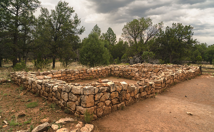
The path is on a shelf where the limestone sits above white sandstone, like found in Zion National Park. The limestone erodes faster than its foundation, and like an ice-cream scooper, that erosion has gouged shallow caves into the white stone. Here is where the Sinagua built their homes. While descending the stairs, I could see dwellings on the opposite side of the creek. They’re spaced apart, so I thought that I get to shoot one or two of the rock dwellings. I was wrong. The canyon’s far side faces north—not the ideal winter location. On the island, the homes were south-facing, which helps keep them warm. As soon as I rounded the first bend, rows of rock dwellings were there for me to explore and photograph. But, I had to sit down first and rest a while—I was still shaking from coming down the stairs.

Before I got to the pictures, I had another interesting observation. I thought that since I had made it a third of the way down the canyon’s bottom, I would be able to catch a glimpse of the creek. With the heavy monsoon we’ve enjoyed this summer (yey), the foliage growing on the canyon floor was so thick it completely obscured the creek bed.

I took this week’s picture—that I call Corner Unit—at the end of several homes. Since they run into one another, they usually share a common wall—like our modern apartments. So, this one has two exterior walls, which is unusual for this neighborhood. Since the Park Service didn’t fully restore the walls, you can see the cave’s overhang and back wall. With it being open to the outside, you can get an idea of its area. The Sinagua people must have felt comfortable with this size because it’s representative of them all. If you think about it, this is a perfect size for a man cave. There’s room for a corner TV, and you can grab a brewski without getting out of the Barkalounger. Once again, however, you’d be stuck at home all day waiting for Larry to show up.

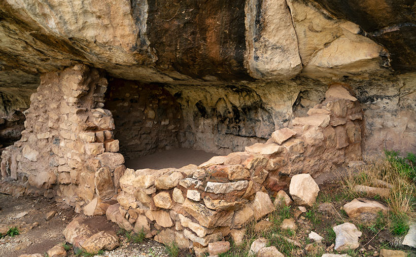
The problem with the man-cave theory is that the women built them and were primarily concerned with keeping in the warmth. In the second image, you can see where they left a vent near the ceiling. These vents allowed them to have small fires inside and let the smoke out. They were their chimneys. The families could survive the high-altitude winters by draping an animal skin or rug over the door and building a small fire.

Fire Vent and Clay Finish - The Sinagua People built vents into the walls so they could enjoy a fire and not suffocate. They also stuffed clay into the rocks to seal the rooms from drafts.
Fire Vent and Clay Finish – The Sinagua People built vents into the walls so they could enjoy a fire and not suffocate. They also stuffed clay into the rocks to seal the rooms from drafts.

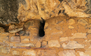
The second picture also shows another innovation the women used to make winter life bearable. They hiked to a place up the creek where they could dig gold-colored clay (the color’s not essential—this isn’t The Real Housewives of Beverly Hills), then they packed it in baskets, lugged it back, and smeared it over the rock walls—inside and outside. Like caulk, the clay sealed the wall gaps and stopped drafts. The women put a lot of thought and work into their homes—the men were too lazy to take down the Christmas decorations.

After I finished my tour of the loop and got the needed photos, I was back at the foot of the stairs leading to the visitor’s center. I found out that the ranger lied. Somehow while I was out of sight exploring ruins and taking pictures, the park service snuck in and doubled the stair count. How do I know; math, simple math. I knew I would have a tough time with the climb, so I devised a system where I would climb 50 stairs at a time—then stop for water and catch my breath. Instead of five rest stops, I made 10, and I drank both of my water bottles dry. Near the top, where I could finally see the building, I made one last effort; one, two, three, four, twelve, fifteen, thirty-five, fifty. I need another rest.

I hope you enjoy seeing the ruins in Walnut Canyon. You can view the Web version of Corner Unit on its page by clicking here. Next week, I’ll have another shot from the Island Trail for you to see, but please don’t make me go down there again.

Till next time
jw

Sinagua Pueblo Picture of the Week

Sinagua Pueblo - A two room stacked-stone ruin that the Sinagua people used for ceremonial purposes.
Sinagua Pueblo – A two-room stacked-stone ruin that the Sinagua people used for ceremonial purposes.

When Queen Anne and I married, we lived most of a decade in a second-floor condo. Besides living in cramped quarters, the thing we most disdained was lugging groceries from the parking lot and up those stairs. My right knee cracked with each step. We swore then that we’d never live in a two-story house.

The Sinagua people would’ve considered us Snowflakes. Imagine your family living in a small cave with a plastered rock façade built on the side of Walnut Canyon. They scaled the canyon walls (without stairs) to get to work. Once on top, the men tended small patches of fertile soil along the edge. They grew drought-resistant crops because their name means Without Water. At least, the Spanish called them that when they first visited the canyon. For protein, they hunted deer, elk, and big horn sheep. After butchering the game, they stuffed the meat into Safeway plastic bags and lowered it on ropes.

Given my extreme age, my most significant anxiety would be getting up in the middle of the night for a glass of Water. As it is, I struggle to find our kitchen in the dark, much less climb down to the creek and back. Of course, their local wise man was in his thirties, and he knew when to stand up and declare, “Today is a good day to die.” Then as he tossed his blanket over his shoulder, he’d tromp out of the camp to the nearest mountaintop, where he’d sit for weeks until dying of starvation. Once again, I’ve proved that exercise is unsuitable for you.

There are many disadvantages to living on a cliff-side cubby hole, but for me, it’s the TV reception. It’s lousy down there. You’d need to get cable or a satellite dish. Then you’d waste time waiting for the cable guy to show up.

There are two trails for you to explore when you visit Walnut Canyon National Monument. Both are under a mile long. The Island Trail is a loop that drops into the canyon, past several dwellings, and then climbs back to the rim. We’ll explore it next week. The Rim Trail stays on top of the mesa and is easier to hike. It goes past some old crop fields and a couple of ruins. I took this week’s picture on the Rim Trail.

The image that I call Sinagua Pueblo shows a two-room stone building of generous size. This structure was probably a communal building for ceremonies and grain storage, like your condo’s community center. Here is where the Sinagua unloaded their trucks after a Costco run. Surely you realize that I’m joking. Flagstaff doesn’t have a Costco. Recovered artifacts show that the Sinagua traded with the villages at Eldon Mountain, Wupatki, and Homolovi—after a short train ride to Winslow.

As you quietly stand and admire the pueblo’s stonework, you can hear Sinagua ghosts laughing, smoking peyote, and chanting with the rhythm of deerskin drums late into the night—until the neighbors come by and yell, “turn down those damn drums.” More cowbell.

I hope you enjoy seeing the pueblo at Walnut Canyon. You can view the Web version of Sinagua Pueblo on its page by clicking here. Next week, we’ll explore the Island Trail and show those photos—if I can only make it up this last flight of stairs.

Till next time
jw

Walnut Creek Bend Picture of the Week

Walnut Creek Bend - It's perplexing to understand how a normally dry creek could carve a deep gorge into the surrounding limestone.
Walnut Creek Bend – It’s perplexing how a usually dry creek could carve a deep gorge into the surrounding limestone.

We had to break from the heat last month, so we drug the trailer up to Flagstaff. We didn’t escape the humidity, though. Since it’s the height of the monsoon season, the weather in the high country was the same as at home—only 30°cooler. There’s been a lot of news earlier this summer about the Flagstaff fires, so we found an RV park on the west side of town—right where Old Route 66 merges with Interstate 40. When we got there, the seasonal rains had already quenched the burn. U.S. 89, which both fires crossed, had reopened, but Sunset Crater National Monument is still closed. It suffered extensive damage to the campgrounds and buildings (otherwise, the cinder cone and Bonita Lava Flow were unharmed).

Our trip served a couple of purposes. First, I needed topics to get this publication through the balance of the hot summer months. Second, we wanted to take Ritz (our trailer) on a shakedown cruise to see how well it and the Jeep played together. Finally, we longed to sleep under the covers with open windows in air, not contaminated with that old-person smell—we accomplished all of that. It’s hard to describe how wonderful it felt to enjoy a glass of wine outside and listen to the sound of rain on the awning. Besides, there’s no more fabulous evening entertainment than watching a newbie learn how to do their first black-tank dump (go back and watch the 2006 movie RV again).

This month’s project is one of the excursions we made to a place that neither Queen Anne nor I have ever been to—Walnut Canyon National Monument. I’m not sure why we missed it. It’s only a couple of miles south of I-40 on Flagstaff’s east side. As you drive the road south, it transitions from Ponderosa Pine to Juniper, so the elevation is lower than the town. The monument is primarily known for the Sinagua cliff dwellings—which I’ll discuss in the upcoming weeks, but it’s the creek we’re interested in today.

On the Colorado Plateau, water generally flows to the Colorado River. In Flagstaff, however, someone put our state’s tallest mountain in the way, so water has to drain around the San Francisco Peaks. A couple of miles west of town, you cross the Flag Divide, where streams flow west of the mountains. East of the divide is the Rio Flag and Walnut Creek Drainage system. Here the streams flow east of the volcanoes into the Little Colorado River. Walnut Creek drains Mormon Lake, Upper Lake Mary, and Lower Lake Mary. You can count Arizona’s natural lakes with one hand, and this little creek drains three of them. Perhaps that explains how an ordinarily dry creek could carve a deep channel into the limestone. Of course, all of that happened before our 22-year drought. Today, Mormon Lake is a broad, shallow dry lake with a mud puddle marking its deep spot, and both Mary Lakes are similarly low.

In this week’s picture, we’re standing at a spot that overlooks a horseshoe bend in the creek. I took this photo from the north side of the canyon facing south. In the distance is Mormon Mountain, some 16 miles south. The lake is located on the left flank of the mountain. When the creek is wet, water flows from right to left and empties into Rio Flag several miles downstream. Then the river turns north and flows under I-40 until it reaches the Little Colorado River, about a mile east of the Grand Falls (sometimes called Chocolate Falls).

I hope you enjoy discovering Walnut Canyon and seeing this week’s image. You can view the Web version of Walnut Creek Bend on its page by clicking here. Next week, we’ll hike one of the trails and poke around some ruins displayed in the national monument. I hope you’ll join us.

Till next time
jw

Water Tank Picture of the Week

Water Tank - The Richardsons added a water tank on their to ensure there was water during dry periods.
Water Tank—The Richardsons added a water tank to their property to ensure water availability during dry periods.

 It’s a miracle! We changed seasons on Tuesday, and we had our first summer rain on Thursday night. Getting rain during summer isn’t unusual, but getting it so soon was. It was nice to finally break our six-month dry spell. It wasn’t a deluge, but enough to tamp down the dust.

Our storm cell came through at 1:00 am, and I listened to the thunder approaching in bed. The weather service says you can tell how far away the strikes are by counting the time between the flash and the thunderclap. “If you count the number of seconds between the flash of lightning and the sound of thunder, and then divide by 5, you’ll get the distance in miles to the lightning: 5 seconds = 1 mile, 15 seconds = 3 miles, 0 seconds = very close.” As I lay in bed, I counted one, two, three …, and then there were a couple of strikes where I didn’t get to finish the one. That’s when I got up.

When I did, Queen Anne was already outside—in the dark—dressed in a T-shirt and flip-flops, moving flower pots around so the rain could water them. I scolded and reminded her about the 3 S’s (snakes, spiders, and scorpions). She seemed oblivious to the blue-white lightning streaking dozens of miles across the black sky above her head. At first, I was concerned that the strikes would start another wildfire because they struck close around us. When the rain started falling, it eased my mind, and I quickly got bored and went back to bed.

According to forecasters, we’re supposed to have an above-average monsoon this season. That’s good because our drought has lasted nearly 20 years. I’m not optimistic that I’ll see a recovery in my lifetime. Climatologists told us of 100-year droughts in the past, and they conjecture that those dry periods may have caused the Anasazi, Sinagua, and other Pueblo tribes to move in search of water.

Water has always been a concern in the desert west. That’s as true today as it was when the Richardsons homesteaded their place in Union Pass. There was a spring near the pass that supported their cattle and orchard. Can you imagine hauling water up 3000′ from the Colorado River? Even with a spring, they need a healthy water reserve to get through the dry months.
As you can see in this week’s photo, Water Tank, they built a large tank on the property for water storage. From this image, I guess the tank dates back to when they made the gas station. The concrete foundation work looks similar to that of the pump island.

I’m sure vandals added the graffiti and bullet holes to the tank’s side after the family moved off the property. They are another example of vandalism that supports my argument that the BLM should set this homestead aside for protection. Otherwise, these ruins won’t be around much longer.

I hope you enjoyed our month at the Richardson Homestead. You can see a larger version of Water Tank on its Website by clicking here. Next week, we begin a new project in a different location. Hopefully, it will be somewhere cool. Please come back then and see what Queen Anne picked for us.

Till Next Time
jw

Sideyard Picture of the Week

Sideyard - The west facing facade of the Richardson home bathed in early morning light.
Sideyard – The west-facing facade of the Richardson home bathed in the early morning light.

This week, we reluctantly leave last week’s Cozy Bed by the Fire and step outside of the historic stone house to explore further. On that May morning, the air was crisp, and the smell of sage-flavored tree pollen filled the air. They were sure signs that spring had come to the 3500′ Union Pass. Since I had spent the night at one of the river casinos, I had on my summer uniform—shorts and a T-shirt. The 60° temperature was perfect for encouraging me to keep moving.

I only took a few steps into the Sideyard before seeing the composition that triggered my instinct to take this week’s shot. It’s the west face of the Richardson house covered with a corrugated tin roof. It’s in pretty good shape, so I’m surprised that poachers haven’t already salvaged the metal.

Two weeks ago, Fred commented on the Richardson House post. He said, “…I admire people that can build rock houses. Not easy!” I agree, and as I processed this image, I wondered how John Richardson learned to build a rock house. This morning, I searched YouTube and found over a half dozen videos on the task, but John didn’t have that resource in 1897, did he? I understand his use of local volcanic stones—that makes sense. But, I have many other questions: did his dad teach him how to build, or did he take classes at night school?

To further appreciate this century and a quarter-year-old structure, we must remember that the family of five moved to Union Pass from Los Angeles because he had a respiratory disease. Lugging boulders around is fatiguing work for the healthiest of us. If Queen Anne suggested that I build a new home out in the Black Mountains, I’d look around at the rocks, trees, and water supply; then, I’d go hunting for a large cave. It would be faster for me to invent a giant 3D printer than to hand-lay all those rocks.

Maybe people back then were more resourceful than we were. My dad was. Once, in a land far away and a time long ago, my wife and I converted a spare bedroom into a den at our Scottsdale house. We had to pause because we needed shelves for the enormous 24″ TV we wanted in the closet space. In those days, we didn’t have Lowe’s, we had Sears and lumber yards were closed on Sundays. When my dad came by and we showed off our work, he drove to America’s department store and bought the cheapest skill saw they sold. Then he cut up the bi-fold closet doors and built our shelves out of the garbage we planned to take to the dump. Voila, we watched the football game on the big screen in our new den that evening. I never thought to re-use the scrap wood even though most of my brain cells still functioned then. It’s even worse today. Some mornings, I spent minutes staring at the back of the fridge until I remembered coming into the kitchen for a coffee spoon.

I didn’t appreciate how clever my father was until I had to stand alone. So, if you’re fortunate enough, hug your dad for no reason on this Father’s Day. Show your appreciation while there’s time.

You can see the larger version of Sideyard on its Web Page by clicking here. Come back next week, and we’ll see what shot I can come up with to finish our month with the Richardsons.

Till Next Time
jw