Skull Valley Station Picture of the Week

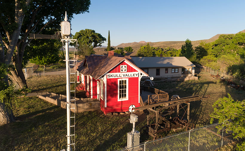
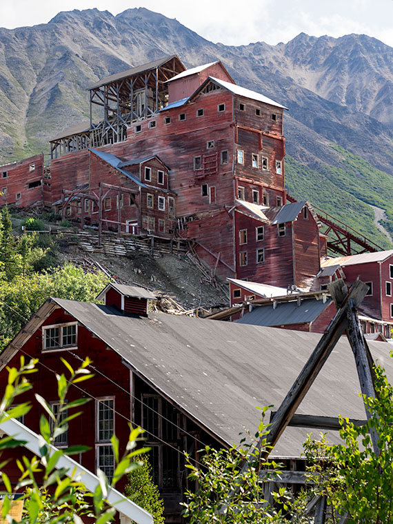
It’s been a while since I pointed my camera at an old building. The last time I did that was before we were all locked up last year. I did publish that shot of Oatman’s empty streets last year, but that image spoke more to desertion than to historic buildings. I missed this genre because I spent time working on other Skull Valley buildings after I shot the train depot the previous week.

Shooting architecture is a discipline different from nature photography. That’s because lens distortion is more noticeable when you’re shooting boxes. That’s why view cameras have movements that allow the artist to correct for perspective distortions. These days, you can fix that in Photoshop—to a degree. A photographer can use a couple of other secrets to minimize camera distortion that I could reveal to you, but then I’d have to kill you.

As I grow older, history becomes increasingly important to me, so I wish to share the story behind each building I photograph. However, most of my subjects are ordinary, and they’re only historic because they survived the wrecking ball. As a better researcher, I could visit the local museums and city halls to uncover records. Unfortunately, I won’t because I’m lazy. If it doesn’t exist on Google, then it never happened.

Skull Valley Station - Located on Iron Springs Road in Skull Valley on the north side of the Peavine tracks.
Skull Valley Station – Located on Iron Springs Road, it is situated in Skull Valley, just north of the Peavine railroad tracks.

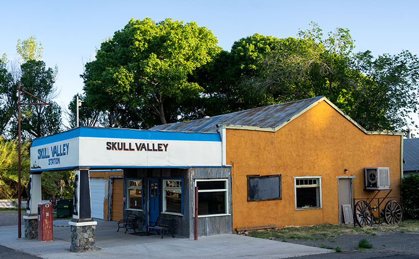
Take this week’s featured image, for example. Until this year, the building was used as a feed store by tenants. The pandemic was terrible for their business, and they closed shop early this spring. I’m not sure when someone last sold gas here, but the pump is set to 33 cents per gallon. I found an article from The Daily Courier that suggests a previous owner, Bob Colbert, didn’t know he owned a service station until he uncovered the original sign beneath layers of paint. Someone has reapplied paint to the sign again (I wonder what happened to the other two pumps).

We drive by this building each month on our way to the Prescott Costco. It’s on the right, immediately after Iron Springs Road crosses the Peavine tracks I mentioned last week. I never stopped to take a picture because of the feed signs, and newer vehicles were always parked outside. They kinda ruined the old-gas-state motif. This time, with the early-morning light illuminating the cottonwoods and speckling the orange façade, I took the time to shoot the station from several angles. This week’s featured image is the version I liked best. I called it Skull Valley Station. What else could I call it?

Click here to see a larger version of Skull Valley Station on its Website. We’ll be around Skull Valley for another couple of weeks, so come back and see what else caught my attention.

Until next time — jw

Skull Valley Depot Picture of the Week

I’m not considered a sociable person, so you may be surprised that I joined a car club back when I was a younger man—more than half my life ago (oh jeez, where has it all gone). This club’s existence was based on owning a particular brand—which one isn’t important for my story—but the club member’s general attitude was that no one should drive one of these cars because the mileage brought down their value. Insane, I know. Despite that, the club put on well-attended events like parties, tours, meetings, and track days.

The club event that drew the most participation was their annual progressive dinner. If you’ve never heard of that, it’s a three to seven-course dinner served at the volunteers’ houses who prepared each course. So we’d meet at the appetizer house, have a glass of wine, and when the food was all gone, we’d jump in our cars and drive to the next course. The club paid for the food and a couple of jugs of Carlo Rossi wines, and members paid a flat per-head attendance fee. The club made a lot of money. Things were different then. Phoenix had few roads north of Northern Avenue, and traffic was nil on Saturday nights, so by the end of the evening, the drive between houses turned into a Targa Florio race. Half the club would wind up in the slammer on DUI charges these days, and the insurance companies would cancel their policy.

Now hold that thought in the back of your head while I talk about the other part of another one of my grandiose ideas. I’ve written before about the trains that pass our house. They run less than a half-dozen times each day (and night), so the tracks are empty most of the time. The route runs from Phoenix to the northern town of Ash Fork, and it has so many twists and turns that it was dubbed The Peavine Line when it opened a century ago. The tracks run through the heart of Arizona’s historic gold mining country.

Historically our little train used to carry passengers with depots in Phoenix, Wickenburg, Congress, Kirkland, Skull Valley, Prescott (now bypassed), and Ash Fork. Most of the town’s stations are still there in one form or another. And—unlike the routes between Phoenix to Tucson and Phoenix to Yuma—there is some interesting backcountry scenery and at least two climate zones along the journey.

Skull Valley Depot - The townspeople of Skull Valley have put their abandoned depot to good use as a local museum.
Skull Valley Depot – The townspeople of Skull Valley have put their abandoned depot to good use as a local museum.

So, after my photo outing where I shot this week’s featured image in Skull Valley, I began to fantasize about having a progressive dinner—on a train. The trip would start in Wickenburg (or maybe Sun City West), then make scheduled stops where the old stations are. At each stop, you could peruse the local museum, enjoy the designated course, spend money on useless trinkets in the gift shop, pee, and get back on the train. Between stations, the guests could taste wine samples (from Arizona vineyards?) and purchase bottles that they would pick up at the evening’s end. At the end of the line, the train would make a leisurely two-hour trip back to the station. The night will have fallen by that time, and guests would enjoy non-alcoholic beverages to sober them up.

I only know of two train excursions in Arizona; the Verde River Line and the trip from Williams to the Grand Canyon. There once was the White Mountain steam train, but that closed a long time ago, and Durango bought the engine (which fell off the trailer along US 89—however that’s another story). I think there’s plenty of market for another train ride in our state, and the dinner would make it a unique experience. Think of it as a dinner cruise on rails.

If this lame-brain idea sounds good to you, then it’s yours. On the other hand, if you feel it’s a stupid idea, I never said anything. My brain hurts too much to work on stuff right now. I’m too old and penniless. Besides, it’s time for my nap.

You can see a larger version of Skull Valley Depot—the picture that set my brain on fire this week—on its Web Page by clicking here. Be sure to come back next week when we continue with another Skull Valley artifact.

Until next time — jw

Verde Limestone Picture of the Week

For centuries the Verde River Valley has been a peaceful home for many peoples. It makes sense because the Verde River flows year-round, even in times of drought—as we have now. The green waters of the Verde—Spanish for green—flow between the Black Hills (Mingus Mountain) on its south-west flank and the Mogollon Rim to the north-east. The river runs from Chino Valley to Fountain Hills—170 miles. It collects the runoff water from the rim via its tributaries like Sycamore Creek, Oak Creek, Beaver Creek, and West Clear Creek. Although the river bottom is a dense cottonwood forest, its flood plains are perfect for growing corn and squash.

There are many sites of early inhabitants along its length, but the best known is the pueblo of Tuzigoot—built by the Sinagua people in the 10th century. They only lived there for a couple of centuries before moving on. The next settlers to arrive were Apaches—Canadian migrants that were chased off the plains by the Sioux. The various bands of Apache established homes along the transition zones across Arizona and New Mexico. They weren’t aware that their new landlords were the Spanish, who were mostly interested in saving their souls and stealing their gold. For the next 300 years, life in the Verde River Valley was peaceful.

Then one day, in 1821, there was a knock on the door—er, teepee flap. It was a government man. He was there to inform one and all that they were Mexican citizens now and, by the way, do you have money to chip in for our new country?

After that, things began to happen fast, and life seemed to go downhill quickly. A mere 30 years went by when another man rode up on a horse, shook a bunch of hands, handed out flyers, and declared, “Welcome to America.” The very next year, Californians discovered gold, and easterners clogged up the trails rushing to get to it. Some got rich, but most of them didn’t get to the Golden State in time, so they made their way back and decided that our valley would be an excellent spot for a farm. There was a civil war going on back home anyway, so they moved into the neighborhood. The Apache’s homeland began to shrink.

In 1864, the Americans stuck a flag in the ground and called it Fort Whipple—the Arizona Territorial capital. The next year they moved the flag from Chino Valley to a mining camp on Granite Creek. The Army stationed cavalry troops to protect the miners, and that later became the town of Prescott.

Life was tense, but there was an uneasy truce between the tribes and the new settlers until those mangy miners started working the Verde Valley. They picked at the rocks, piled dirt everywhere, muddied the water, ate all the food, and drank all the whiskey. It was the straw that broke the Gila monster’s back, and the Apache tribes declared war—Yavapai War (1871-1875). That’s the precursor of General George Crook’s assignment to Fort Whipple and his trail to Fort Apache that we began exploring last week.

Verde Limestone - A limestone ledge in the Verde River Valley in the lovely light of the evening sun.
Verde Limestone – A limestone ledge in the Verde River Valley shines in the lovely light of the evening sun.

This week, we traveled east along the Verde River for a few miles and stopped near Dry Beaver Creek to photograph a limestone formation. They’re found throughout the valley and are most evident on the river’s north side. As you travel Interstate 17 towards Flagstaff, it’s the white layer between the Verde River and Sedona. Limestone forms in shallow seas from dead shells and bones. It’s a great place to look for fossils, and coincidently one of our planned stops was to be Fossil Creek, but it was closed due to COVID 19.

This week’s featured image—called Verde Limestone—shows a ledge exposed by years of erosion. For balance, I included the lower mound of the same compound shining in the lovely evening sunlight.

You can see a larger version of Verde Limestone on its Web Page by clicking here. Be sure to come back next week as we climb out of the Verde Valley and see what we found along the General Crook Trail.

Until next time — jw

Parade Grounds Picture of the Week

We Arizonans have it easy these days. Within a matter of hours, we can drive from the beaches of Yuma to the Flagstaff snowfields. We’re able to do that because of our modern cars and roads. With their bridges and gentle slopes, we forget how rugged our State’s terrain is. We sit in our air-conditioned cocoons and watch the scenery pass, without having to wonder, “How the hell am I going to get over that?” And the closest we ever come to getting scalped is from the guy selling souvenirs at The Thing.

Arizona was a different place when Martha Summerhayes arrived at Ehrenburg Landing via paddle-wheel steamer in the summer of 1874. She accompanied her husband—Jack, a Lieutenant—when the Army assigned him to the territory. She writes in her now-famous book—Vanished Arizona, Recollections of the Army Life of a New England Woman—about their travels to posts within our state, including her story of being the first woman to travel the subject of this month’s photo essay—The General Crook Trail.

George Crook was a Civil War officer who was assigned to Arizona to put a stop to Apache raids. Now, I fully appreciate the new awakening in our country about racial injustice, but that’s not the point of my story. I’m merely trying to explain, in my words, the trail’s history. George’s job of managing the Apaches wasn’t easy. They’re not a single people. There are the Chiricahuas, Yavapai, Mescalero, Tonto, and several more in Arizona alone. The tribe’s traditional homes were spread along the Mogollon Rim—the southern escarpment of the Colorado Plateau that slashes across the midsection of our state. It was like playing Whack-A-Mole; he’d quash one uprising only to have another pop-up 50 miles away. It didn’t take long for General Crook to understand that he had a logistics problem. He needed to move troops and supplies quickly from Fort Whipple (Prescott) to Camp Verde, and Fort Apache (near Show Low).

In August of 1871, the General took a company of men to mark out a trail between Fort Whipple and Fort Apache. It took over a month just to get that much done. His route hugs the edge of the Rim because if he went too far north or south, he had to navigate steep canyons. His men took another year to build a trail good enough for pack mules, and another couple of years to make it suitable for wagons.

Today, the General Crook Trail has morphed into a combination of Arizona Highway 260 and the Rim Road (Forest Road 300). The Rim Road is unpaved, and if you travel it, you’ll come across markers for Crook’s original pack trail. You can hike those sections, but a lot of the trail reviews say it’s easier just to walk along the dirt road.

Parade Grounds - A picket fence surrounds the Camp Verde Parade Grounds and make it a lovely back yard for the Commanding Officer.
Parade Grounds – A picket fence surrounds the Camp Verde Parade Grounds and makes it a lovely back yard for the Commanding Officer.

For September’s project, I’m only going to cover the section of A.Z. 260 from Camp Verde to the intersection with A.Z. 77 north of Strawberry. This week’s featured image is from Camp Verde, where they’ve turned the old post into a historical site. The Camp Verde Historical Society has preserved the buildings, built museums, and maintains the parade grounds within the State Park. It’s a great way to spend a day wallowing in history. This week’s image—called Parade Grounds—shows the parade grounds and the surrounding picket fence, with what I suspect is the Commanding Officer’s Quarters behind. How’s that for a back yard?

You can see a larger version of Front Parade Yard on its Web Page by clicking here. Be sure to come back and see our next stop along the General Crook Trail.

Until next time — jw

P.S. Martha’s book, Vanished Arizona, is not just a chick-book. It’s got cowboys, Indians, horses, rattlesnakes, and cactus in it. What more can a boy want? I smiled when she lamented how much Arizona had changed from her 1874 arrival to her 1911 death. It is the same feeling that most Arizonan have even today.

Stamp Mill Picture of the Week

Everyone has heard the axiom, “All roads lead to Rome.” Well, they don’t exist in Yavapai County. Over the past couple of years of traveling Arizona’s back roads, I’ve found that they lead to mines, and with good reason. We all have a vision of a dusty prospector sneaking off with a couple of burros to a secret gold mine in the mountains—this is before he became the Arizona Lottery huckster. A man like Jacob Waltz may discover a vein of gold, but it takes a corporation to extract it effectively.

You have to move a thousand tons of ore to make a ton of money. A few burlap sacks strapped to a burro’s back won’t do. You must move unrefined earth by wagon, truck, or railroad car. So, part of The Company’s infrastructure is getting things to and from the mine site. That is the Phelps-Dodge and the Senator Mine story—and this month’s back road adventure.

While bouncing along the Senator Highway in R-Chee (according to his license plate, that’s the correct spelling), Anne suddenly blurted, “There’s a large building down there.” Since my side wasn’t overlooking the cliff, I couldn’t see it, so I stopped the truck and walked back to see the steel skeleton of an old structure. “Cool,” I told her as I climbed back into the driver’s seat. “It’s too early, so we’ll stop on the way back when the light is better.”

Stamp Mill - The ruins of the Senator mine stamp mill are perched above the headwaters of the Hassayampa River.
Stamp Mill—The ruins of the Senator Mine stamp mill perch above the headwaters of the Hassayampa River. The mill is visible on Google Earth if you zoom in on the Senator Highway, which crosses the Hassayampa River.

After some research, I discovered that the building was a 10-unit stamp mill for the Senator Mines. As rock came from one of the three parallel shafts, the miners hauled it to the mill, where the hammers pounded big boulders into small ones. As far as ghost towns go, we struck gold (I couldn’t resist the pun, sorry). Concrete foundations are usually all we find in these places, but since this frame was steel and not timber, the skeleton survives and gives scale to its size. From the road, I could easily walk down the stairs and wander the four floors. Vandals decorated the remaining vertical walls for Christmas with colorful graffiti everywhere, so I guessed we weren’t the first to find this place.

Kennecott Mine - The Kennecott mining town is preserved in the Wrangell-St Elias National Park in Alaska. This should give you an idea of how a mill looked with the clapboard still intact.
Kennecott Mine—The National Park Service has preserved the Kennecott mining in Wrangell-St Elias National Park in Alaska. This photo should give you an idea of a mill’s appearance with intact clapboard.

I visited a similar mill in Alaska at the Kennecott Mine in the Wrangell Saint Elias National Park. At this location, the Park Service keeps that building in an arrested state of decay and still has the red clapboard siding. I wanted to show you how Senator Stamp Mill might have looked while running, so I’m including my Alaska photo.

For this week’s featured image—Stamp Mill—I wanted to show the building and its environment, which is hard to do while standing inside of it. So, I took this shot from the far side of the Hassayampa River Canyon as the sun hung low in the western sky. I was lucky in that the remaining silver paint glowed in the afternoon sun, making the frame pop from the background.

Click here to see a larger version of Stamp Mill on its website. I hope you like it. Be sure to return next week when we present the final image from our drive on the Senator Highway.

Until next time — jw