Queen Anne and I spent yesterday changing the house calendars, and with a new month, it’s time for a new photo project. I’ve been struggling to come up with an ongoing long-term theme—something similar to last years where we took you from town to town within Yavapai County. I considered several options—all of which I crossed off because they involved exercise and the possibility of having my mug broadcast on a Silver Alert.
To find inspiration, as I frequently do, I grabbed my Arizona Gazetteer Map, went into the library, and scoured through it until my legs fell asleep. In the maps, I saw something that would be interesting as a basis for a long term project. I noticed that there are roads—secondary unpaved roads—all over the state. They’re like the ones around my neighborhood that are well graded and can be traveled in ordinary sedans (in dry weather). For Archie—my four-wheel SUV—they’re freeways. These back-roads go to places I’ve never seen, and because they’re not meant for speed, almost all of you haven’t been on them either. Some of them are dead ends, some lead up into the mountains, and some head off across the desert. Haven’t you ever drive past some side road and think, “I wonder where that goes?”
So, that’s what I plan to take on for a while. I’ll pick a back road and see if it leads to something pretty or novel. Maybe I’ll eventually collect enough material and produce a catalog or magazine of sorts, but I’ll worry about that later. I can always suspend this project when I come across something fresh or different. You might say that this blog, newsletter, or whatever you want to call it, is going from On the Road to Off the Beaten Path.
Conveniently, I had a head start, because a couple of weeks ago, I took my camera and headed up Castle Hot Springs Road. It’s the long way between Lake Pleasant and Morristown, and the only way you can get to the newly reopened Castle Hot Springs Resort where Clark Gable stayed (we’ll talk more about that in another post). The road winds its way through the Wickenburg Range, Buckhorn Range, around the Hell’s Gate Wilderness, and past several working ranches, so there’s lots of eye-candy along the way.

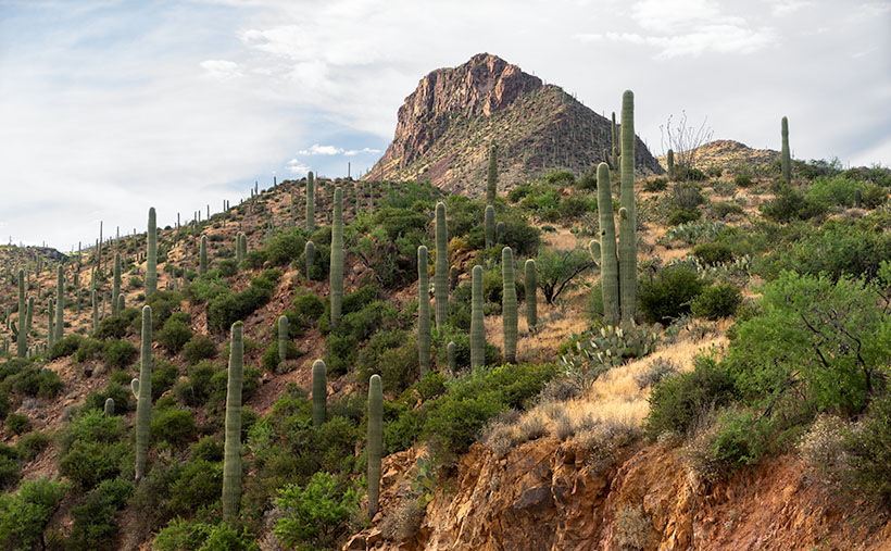
This week’s featured image comes from the area where the road runs through Bitter Creek. The 3700’ mountain is unnamed, and I was struck at how the saguaros grew thick along its flank to the top. At the base of the mountain’s north side, there is a ranch labeled 11 L on my topo map and a water hole named Layton Tank. I like how the vertical cacti resemble the crowds climbing Mt. Everest we’ve seen in the news lately. I’m also pleased that the clouds parted enough to add texture to the sky. I called this image Bitter Creek Saguaros.
You can see a larger version of Bitter Creek Saguaros on its Web Page by clicking here. Be sure to come back next week when we’ll see another beautiful scene I shot on my Castle Hot Spring Road outing.
Until next time — jw

Jim, I think given the back trails and roads you will likely be taking for these adventures, that no “Silver Alert” would ever be put out should you go missing. However, that said, I’m thinking the local Apaches might issue a “Scalp Alert” instead. Better watch your “nine” out there……..
Jim, I believe it is time to get a small camera crew and film your travels for TV. Call it “Wit’s Unknown Arizona”. I truly believe your wit and out of the way places could be the basis of a popular PBS show. I can see it now… Wit’s Unknown Arizona sponsored by LaMesa RV. Give me a green light and I’ll get it going!
Del
Well, that caught me by surprise. Are there any other opinions about Dell’s comment?
At Wit’s End.
The pathway exists, now’s the time to follow your nose. I’m sure ancient copies of Arizona Highways would spark ideas and you’ve proven that you can obtain sponsorship for your passions. Go for it.