What a Doozy

I’ve been reporting about this year’s monsoon season, how afternoon storms roll through here every other day, how they put on a great show, and how they have distinct personalities. Today I want to tell you about last Tuesday’s storm. It was a doozy!

August Storm
The clouds from Tuesday’s storm ran the full gamut of gray, from white to black.

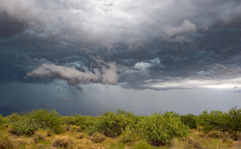
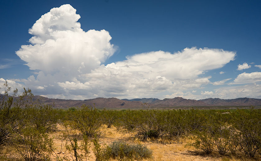
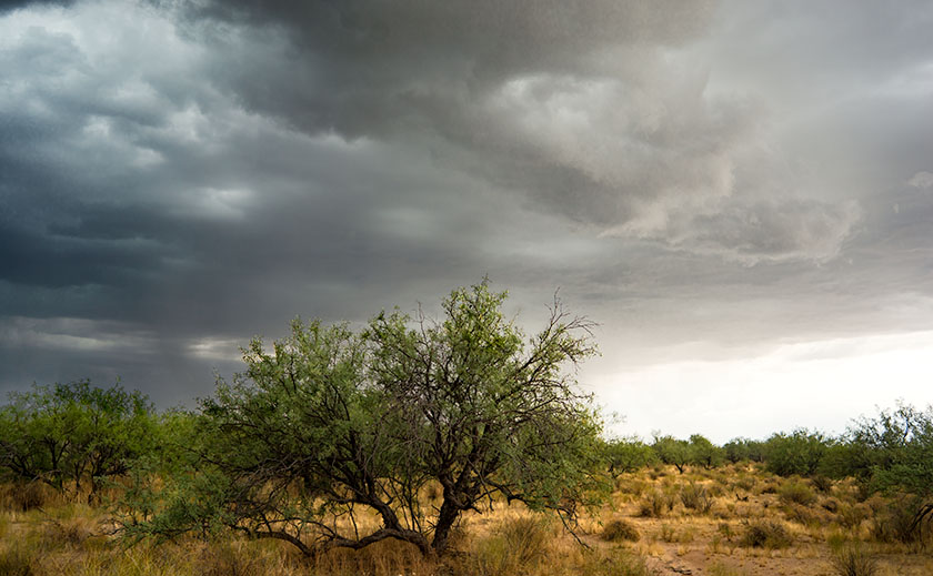
The day started off normal enough, the Queen and I ran into town to do some errands and grab a bite of lunch. As we drove home, we noticed clouds building up in the west and south. We ignored them, because it’s rare that weather comes in from those directions. Since there wasn’t a lot of activity over the mountains that normally affect us, I figured that we’d have a quiet evening. When we got home, I laid down for a nap, but when I woke an hour later, the house was dark. The sun wasn’t streaming in the windows, so I stepped outside to check the skies. Everywhere I looked were storm clouds in every shade of gray; white to black. The most menacing patch was over the pass where Yarnell is. As I watched for a few minutes, I realized it was heading in our direction.

From Yarnell
As the winds pushed through the pass, they began to form vortexes like you often see on aircraft wing tips.

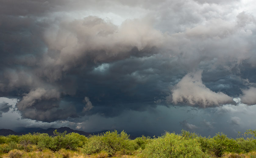
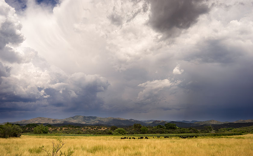
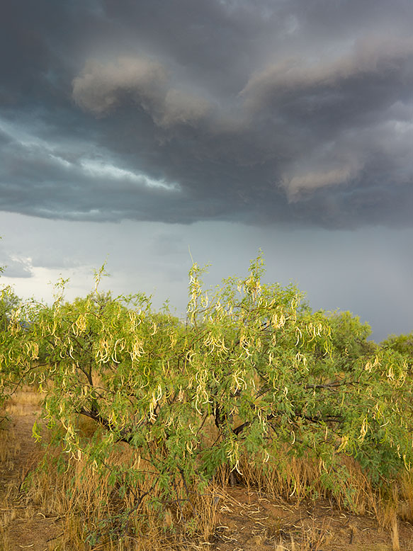
I’ve been having fun and some success shooting storms as they move in this summer. I was playing junior storm chaser and already had a couple of, as I call them, Mitch Dobrowner—light images, and here was another chance at dramatic weather shots. I grabbed my camera and walked down the street to the open desert. As I began clicking off frames, the darkest section of the front cleared the mountain range and began behave oddly. As it forced its way through the pass, it formed a vortex and began dropping in elevation. It looked like the spirals coming off Formula One wings during rain races. Behind the main thrust, the mountains disappeared in a curtain of black rain. Since the storm was closing fast, I started walking back to the house. Half way home, I turned for one last shot, and as the wind picked up, I could feel drops on my skin. When I got back to the house, I told Anne that we have to think about finding a safe place to hide should the storm spawn a tornado.

White House Before the Storm
As I made my way back to the house, I turned to take this shot. After I got home, I told Anne that we may need to find a safe place to hide.

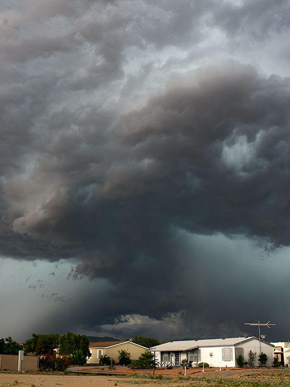
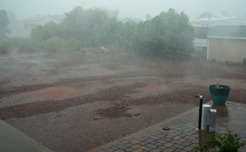
The full force of the wind hit just as we were checking out the kitchen pantry. We watched the front tree blow back and forth brushing its limbs against the porch for a few minutes before we heard a pounding on the roof and kitchen sky light. It was too loud for rain, and we went out on the back deck we confirmed that hail was pelting the house. In a matter of minutes, the hail began to turn our red-rock drive to white, then just as quickly, a heavy rain started and washed the hail away. Even though we were on the leeward side of the house we got soaked because the wind whipped and swirled so the rain was coming in under the roof.

Lake What-a-muck-a
That’s not grain, it’s rain. In minutes the back yard went from rock to covered in hail and finally to Lake What-a-muck-a.

For a moment, I thought about getting my rain jacket and microphone out so I could pose like one of those idiot Weather Chanel reporters do in a hurricane, but I decided not to because I’d have to stand out in the wind, rain, and lightning. Besides, I don’t have a waterproof microphone. In a matter of minutes, the back yard turned into Lake What-a-muck-a.

Meanwhile, out front the streets were fast flowing, knee-deep rivers from curb to curb. The swift flowing water would have knocked you down if you attempted to wade across them. The streets were designed to drain to a wash that cuts through the park, but it was running beyond capacity and couldn’t take any more run-off.

Within an hour the wind and rain stopped. The thunder and lightning continued for a while but finally died as the storm moved south. Anne and I ventured out on the front porch and watched the water slowly recede uncovering sand bars. Neighbors ventured out of their homes and compared notes. Those that have rain gauges said they had 2-2.4 inches for the hour-long storm. I would guesstimate the wind gusts a conservative 60 mph. All of our water ran down the dry creeks to Wickenburg where the evening news had flooding stories.

While out walking the next morning, we were surprised there wasn’t more damage in the neighborhood. A handful of trees had broken limbs, some ocotillos were knocked over and some of the wash’s engineering suffered, but there wasn’t much structural damage. I had to mend some skirting, but that was it. Mostly the people we saw were busy shoveling dirt from the streets back into their yards. Not bad for the storm of the year.

Till then … jw

On Display at National Bank

I’m pleased to announce that my premier print Mt. Hayden is on display in the lobby of Wickenburg’s branch of the National Bank of Arizona. At 24 x 30 inches, it’s the largest framed print in my collection. It’s also notable because it’s entirely analog. That’s right, it was shot on film and printed the old fashion way; in a darkroom.

Mt. Hayden
Taken from the Grand Canyon’s North Rim, Mt. Hayden, at over 8000 feet in elevation, is one of the most recognizable canyon subjects.

I’d be pleased if you’d stop by National Bank and tell the folks that you came to see the Mt. Hayden print. The bank is at 540 West Wickenburg Way; just west of the railroad bridge, and they’re open normal banking hours. The print will remain on display until September 1st. Just for fun, ask if you get a free toaster with a new account.

Till then … jw

The Face of Mother Earth in a Sand Pile

As I wrote earlier this week, we’ve had a pretty good Monsoon Season. The afternoon storms have brought rain every other day. A couple of the storms were short but intense causing a lot of run-offs. The amount of rain is too much for the soil to absorb and so, most of it runs into the street. If the flow is great enough, it will drag sand off the lots on to the street.

On our morning walks around the trailer park, Queen Anne and I come across these sand trails all the time. One of them, however, stopped me in my tracks. I saw something that I recognized and as we examined it, we realized it was a pretty good map of the North American Continent. Alaska, Canada, Greenland, Cuba, and Mexico were all in their places. Missing in the map was Florida, some of the Aleutian Islands and parts of the east coast. With climate change and all, maybe it’s a sign of things to come.

A map of North America in sand run-off
A pretty good map of North America that we found in sand run-off while on our morning walk.

What do you think?

Till then … jw

ps: After three storm cells move through the area last evening, it washed more, sand onto the street. On this morning’s walk, the shape was completely different. Only the Alaska part remained recognizable.

Lunch on the Front Porch

It’s raining this morning, a steady gentle shower that’s driven the outside temperature down to 73°. That’s the lowest reading I’ve seen on our outside thermometer all month. The rain postponed our morning walk until it let up. We made it through most of our route before Queen Anne felt a couple of drops and began screeching, “I’m melting.” By the time we made it back to the house, the point on her black hat flopped over into her face. I’m afraid that she looked like a bit of a cartoon.

It’s been a decent monsoon season so far. We’re getting rain every other day. There’s enough to fill Lake What-A-Muck-A until the waters lap onto the pavers out back. The ground is damp, the saguaros have plumped again and some of the cacti have begun to bloom for the second time.

There’s enough moisture coming up from Mexico that the thunderheads form over the plateau behind the Weaver Range each afternoon. We watch them as they boil in slow motion until they anvil out and spread in their direction of travel. As the hot air rises down here on the desert basin, it acts like a vacuum, sucking the thunderstorms off of the mountain. Here at the house, with our views to the horizon, we watch as the lightning and rain cells pass to the north and south of us. But sometimes, we’re in the path. It’s like playing dodgeball while standing still.

Thunderhead Over the Weaver Range
Each afternoon, thunderheads form above the plateau behind the Weaver Range.

First, come the outflow winds which can gust over 60 mph. That’s why we keep the tree out front trimmed up, so the wind can blow through the top canopy instead of breaking off limbs or blowing the tree over. In the neighborhood, we’ve had nearly a half-dozen century agaves bloom, with a 20-30 foot phallic center shoot. The Christmas tree like stalk gives the wind enough leverage to rip the roots of the four-foot blue agaves right out of the ground.

Skull Valley Monsoon
Monsoon clouds move down from the Bradshaw Range in Skull Valley.

Following the wind is rain. Sometimes it’s only a drop or two that leave spots on your dust-covered car. Other times it’s a gully washer and the streets fill like rivers. Out on the desert floor, the washes run with fast-flowing muddy red water; those are the flash floods that are dangerous even if your miles downstream. Every once in a great while, Mexico sends up enough moisture that you get a long-lasting gentle rain, like today. It’s slow enough that the ground has time to absorb it.

Mesquite Pods
Ripe pods on a mesquite tree will be dispersed in the winds of a monsoon storm.

Conveniently, the rains usually arrive in time for sunset cocktails, and we sit out on one of the covered porches while enjoying a glass of wine. It’s a popular summer past time in Arizona. The temperature drops 10 to 20 degrees below the century mark. The lightning show is always spectacular and can last for hours. With a stiff breeze and the moisture; it’s pleasant outside, besides you have to hold down the furniture somehow.

Mesquite and Monsoon
A mesquite grove is about to get drenched in an afternoon thunderstorm.

It ends abruptly. Shortly after the rain stops, the sweltering black top evaporates the last of the street’s water like hot sauna rocks. The wind dies and the humidity closes in. When it becomes intolerable, you retreat back into the air conditioning, if the power’s still on. There’s time for a TV show before watching the weather. It’s important to find out how the rest of the valley fared before calling it a night.

Till then … jw

El Gato Azul

There are a lot of things we’re thankful for when we moved to Congress last year, but shopping isn’t one of them. Sure we have a couple of local grocery stores and merchants nearby that we make do for basics, and there’s always Amazon for the occasional weird stuff we need, but making a Costco run takes days of planning. The stores are far enough away that we plan our trip into town with multiple stops along the route. Shopping at the big box store is an all-day trip.

Our house is conveniently (if you can call it that) located midway between the two nearest stores. We exclude the one in Sun City because it’s impossible to maneuver around the golf carts and inattentive drivers. Our choice is between the Deer Valley store on I-17 and the one in Prescott. The drive time difference is literally five minutes, so the choice comes down to what other errands we need to run. If I need to pick up some hardwood, we go to Deer Valley. If I need something at Harbor Freight, we head to Prescott (for our friends out-of-state, the townspeople pronounce it ‘Press-kit’ and they’re not shy about correcting you). During the summer though, Prescott wins hands down because it’s in the pines and cooler.

When we make the Prescott run, Queen Anne and I try hard to build in time for lunch, and our favorite place there has become El Gato Azul a tapas place at 316 West Goodwin Street. Goodwin is the street that runs along the south side of the courthouse; the restaurant is two blocks east of Whiskey Row.

El Gato Azul Restaurant
Two blocks east of Whisky Row is the tapas bar, El Gato Azul.

The restaurant building is a small one story box on the east side of the Willow Creek trail. It’s smaller than most fast food chains, and the Dijon mustard colored façade has lavender ledges covered with potted plants and lights. The clutter almost obscures the sign.

To enter, you step down from the sidewalk (an access ramp is a few steps to the right) and walk through the bright blue door. Inside the dining room are two . . . maybe three tables and behind the hostess station, an ‘L’ shaped bar fills the rest of the room. The décor is a mix of upscale Goodwill and early garage sale interspersed with canvases from local artists. If you’ve come to eat, (why else would you be there) the host/hostess will escort you back outside through a door on the right. Here is a large covered main dining area that is open in summer, but enclosed with clear vinyl curtains in winter; portable heaters provide warmth.

The food that we expect at El Gato is not what you’d call rib sticking comfort food, but small dishes as you would find in a Spanish tapas bar, but with a southwest influence. It’s more of a tasting menu where you get an interesting burst of flavor combinations in one bite. As with a Chinese restaurant, it’s fun to pick out several items and share. One dish is not enough for a full meal, but the Queen and I fill up by sharing three items. It’s sort of like making a dinner out of a couple of appetizers. Plates range in price from $10-$13 each, so it’s not cheap. They offer a list of soft drinks along with the stocked bar.

Cajun Corn Dogs
One of the meals we enjoyed was their Cajun Corn Dogs. This consists of bacon wrapped tiger prawn fried in corn batter and a glaze of honey.

The next time you travel up Prescott way and you want to try something different, the Queen and I recommend you give El Gato Azul a try. We recommend it, even though Anne is now annoyed with me for letting The Blue Cat out of the bag.

Till then . . . jw