WPA Legacy: The Historic Cattle Dam of Gold Butte Picture of the Week - Mesquite, Nevada

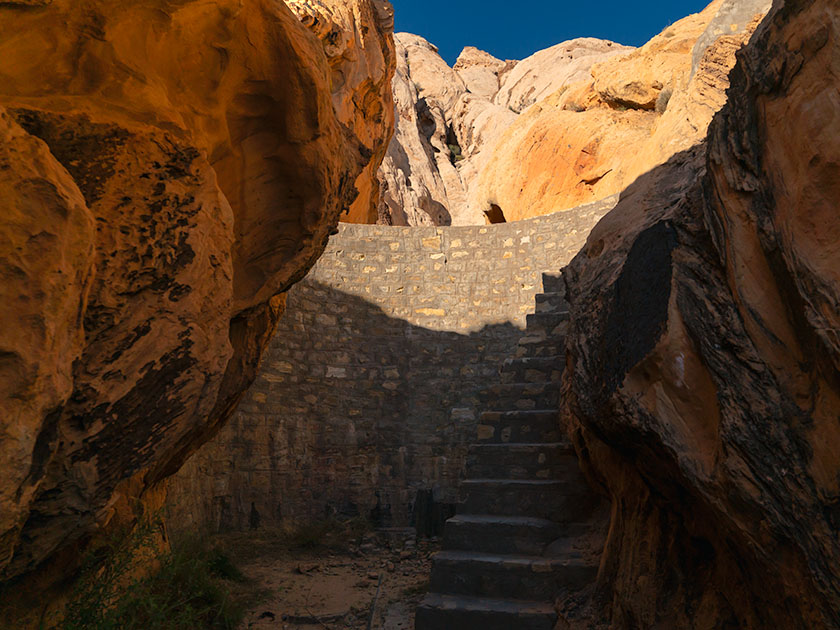
WPA-built stone dam between rock formations in Gold Butte National Monument, captured by Jim Witkowski.
WPA Legacy: The Historic Cattle Dam of Gold Butte – Stepping Through Time: This WPA-constructed dam at Gold Butte stands as a rugged monument to past endeavors, harmonizing with the arid beauty that surrounds it. A silent witness to history, its stones speak of a bygone era of hope and hard work.

Victorious in my quest to capture the ancient whispers etched into stone, I returned to our trusty steed, the Turd. There, amidst the dust and echoes of bygone civilizations, sat Queen Anne; her latest book–escape, concluded. Her gaze met mine, an unspoken dialogue of adventure’s end, punctuated by a brief, ‘Can we go now?’ Her tone carried the weight of a royal decree, yet I knew the kingdom’s treasury of wonders still had one gem left to unveil.

At the end of the infamous paved road, you can turn south towards the abandoned town of Gold Butte or go straight towards the Arizona border and the Grand Canyon—Parashant National Monument. Both roads are equally evil to drive on, but I wanted to find another relic of history—a WPA-era dam, so I started east. We didn’t travel far because I spotted a cistern on the left as soon as we drove through the first dry wash. I pulled the truck over and grabbed my camera.

The cistern looked like a dry concrete bathtub, and a rusty pipe beckoned from the cistern to a narrow canyon on the right. A couple of creosote bushes blocked the view (and the path), so I brushed them back with my arm and saw the dam. It looked like a scale model of the Hoover Dam 50 miles downstream. Although it was built in the 30s and no longer maintained, it looked like it would still hold water if you closed the gate and valves. It is another testament to those folks’ work during the Great Depression.

After getting some shots, I wanted to see how deep the backside was, which meant climbing the stairs. In my younger days, I would have said, “Nothing to it,” and jogged up the stairs. But there’s no handrail, and my balance isn’t the same, so I did it the hard way—backing up one step at a time while sitting on my butt. I got my dose of vertigo and started back down the stairs when three outdoorsmen walked through the slot. My face turned red, and I apologized, “Sorry guys, this is how we geezers climb stairs these days.” One of them quipped, “We understand—Mister Girly-Boy.”
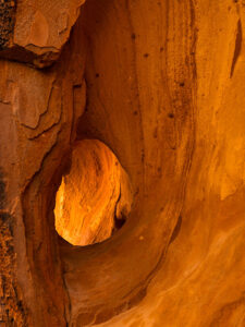
An erosion-formed window in a sandstone canyon wall, illuminated by sunlight at Gold Butte, photographed by Jim Witkowski.
Nature’s Art Frame: The Erosion Window of Gold Butte -Carved by the patient hands of time and elements, this erosion window in Gold Butte’s canyon wall frames a story millions of years in the making—each layer a verse in earth’s grand narrative.

This week’s other photo is of a natural erosion window along the canyon’s narrow. Unless you’re the stature of our friend and frequent commenter, Deb Poteet, you can frame your face with it by standing on your toes. As usual, Anne wouldn’t get out of the car, so I had to settle for shooting the opening without her pretty face. Still, it’s pretty cool.

In the mirror

Queen Anne and I covered a lot of ground this year. We visited two California Wine regions without being tossed out on our ears. We followed some of our favorite trails and got reacquainted with the charming cities of Bisbee, Tombstone, and Douglas. We explored the Beeline Highway and the Mazatzal Mountains, shot wildflowers in the spring, got caught in a monsoon storm at sunset, and discovered some fantasy shapes in Prescott’s Granite Dells City Park. With pandemic restrictions lifted, we did a decent job of broadening our range and bringing you more diversity with this year’s photos and stories.

This has been a year of growing for us. I’ve tried to improve my writing skills. I completed a couple of online creative writing courses. You’d think it would make my work more manageable, but it didn’t. What I used to knock out on a Sunday morning now takes me three days of writing, editing, and revising before I’m ready to publish. I also invested in a grammar checker that—hopefully—gets most of the commas in the right places.

I’ve been tinkering with my photo processes by watching online photographers. I picked up some new tips and tricks, which I’ve tried to pass along to you in the Techniques section. I think you found them helpful because I’ve received positive feedback from you. Finally, to attract new subscribers, we started producing monthly YouTube videos. In each of the last few months, I converted one of my static portfolios into a five-ish-minute video with music and voice-overs. With these new videos, we’re blending the old-world charm of static images with the zippy excitement of moving pictures—without the smell of darkroom chemicals. It seems to be working because my web traffic is on the rise.

Through the windshield

I have an Arizona wall map on our laundry room wall with colored dots indicating the places we’ve visited in the last couple of years. Instead of being evenly distributed, two empty spots glare at me from the map. The first is along the southern border between Nogales and Yuma. Since that’s restricted chiefly to military ranges, there’s not a lot I can photograph without starring in my impromptu sequel to North by Northwest. The other section is the northeast corner of Arizona—the Navajo and Hopi reservations. I intend to paste a dot or two in that corner next year. Maybe you could suggest some locations.

There’s more to discover at Gold Butte National Monument. I plan to return this spring if the Turd’s crummy tires ever wear out. Getting stuck out there without communication is a genuine concern for us. Some sights we missed this year include Devil’s Throat, the remains of Gold Butte’s ghost town, and Little Finland.

Finally, next year’s wine region adventure will be in Northern California. Will it be Napa, Sonoma, or the Russian River? Let us know where your favorite California wine comes from. We haven’t picked a winner yet, but the trip will be in August. As Samuel Clements once said, “The coldest winter I ever spent was a summer in San Francisco.” Some dispute that the quote is genuine, but for us desert dwellers, it’s a challenge.

Queen Anne and I wish you a very happy and prosperous New Year. We hope you’ll continue joining us on our escapades and maybe invite some friends. We’re always delighted to see you in the back seat. Feel free to share your New Year’s adventure plans in the comments below. They give us ideas for which roads we take.

Till next time, keep your spirits high and your humor dry.
jw

BTW:

Last week, I released my latest YouTube video based on my portfolio of pictures of California. It’s five minutes of eye candy, and I invite you to see it by using this link: [https://youtu.be/cgXAHPyzQ5Y]

Geologic Puzzle: Unearthing Whitney Pocket’s Sandstone Secrets Picture of the Week - Mesquite, Nevada

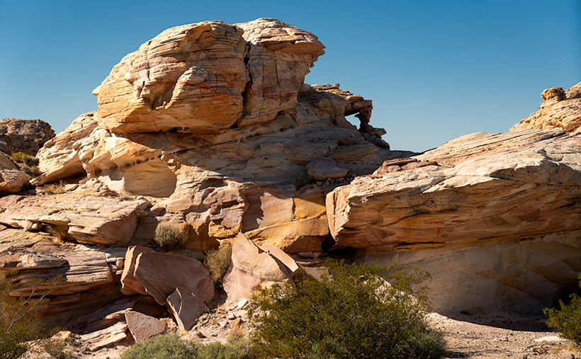
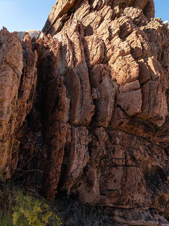
Brown layered Navajo Sandstone uplifted and eroded by fault activity in Whitney Pocket, with unusual rounded edges and color variation.
Geologic Puzzle: Unearthing Whitney Pocket’s Sandstone Secrets – Nature’s Tilt: Witnessing the Story of Uplift and Erosion in Whitney Pocket’s Sandstone Layers.

Arriving at a new location like Gold Butte ignites a whirlwind of excitement in me, and my initial instinct is to capture everything in sight. This flurry of photography is more about immersion than precision, leading to a digital pile-up that I inevitably sift through, discarding the excess like chaff. Unlike the costly days of film, where each shot was a precious commodity, the digital age allows me to indulge in this initial creative outburst, knowing it’s part of reaching the true gems.

Once the initial rush subsides, I transition from capturing to contemplating, delving into the ‘why’ and ‘how’ of the landscape before me. It’s here that Shawn Willsey’s geology videos come into play. As a professor at the College of Southern Idaho, Shawn has a gift for demystifying the complexities of earth science, guiding even the uninitiated through geological wonders. His explanations, particularly his Random Roadcuts segments, clarify unusual layering and erosion and bring a new depth to my photographs, transforming them from mere images to stories set in stone.

From a distance, the formation in the picture above looked like the blades of a turbine engine embedded in the Navajo Sandstone. For all I know, there is a 747 out there with the guts missing from one of its engine cowlings. The brown color, multi-layers, with rounded edges, stood out like the red marks on one of my term papers. How can I tell you about it when I haven’t a clue? So, I emailed Professor Willsey and asked if he’d look at my photo—and he accepted. He answered, “The feature in question is not a vein but appears to be an upturned section of Aztec (Navajo) sandstone. The near vertical layering is the cross beds deposited on the dune field’s backside (downwind) side. Some faults and other structures in this region of NV are likely the culprits that have tilted the rock layers. Very cool.” Then, he returned to hosting his live coverage of this week’s Iceland eruptions. Now, don’t you feel smarter?

A butte in Whitney Pocket with layered Navajo and Entrada sandstone, with the red end facing south, creating a 'Neapolitan ice cream' effect in the desert.
Neapolitan Earth: Unraveling Whitney Pocket’s Colorful Geology – Stratified Delight: The Neapolitan Butte of Whitney Pocket, where Geology Meets Gastronomy.

There’s a question in this week’s other picture as well. It’s an image of a sandstone formation that looks like a bowl of Neapolitan ice cream after Queen Anne was done with it. I say that because Queen Anne always eats the chocolate and turns her nose up at the rest. The issue is that the red section appears on the white layer. From all I’ve read, the Entrada era—with its rust-colored sandstones—came before the white dunes. My best guess is that the forces that lifted the Virgin Mountain Range over a mile in the air also jumbled the natural order in this basin. What are your thoughts?

I have posted larger versions of Geologic Puzzle on my website < Jim’s Web> and my Fine Art America page <FAA Link> should you want to examine the layers closer. Next week, we wrap our foray into Gold Butte National Monument with one of the rare evidentiary remnants that anyone preceded us. It’s like unearthing the Spinx. Join us then, won’t you?

Until next time, keep your spirits high and your humor dry.
jw

BTW:

As we gather to celebrate the holiday season, Queen Anne and I would like to extend a hearty Seasons Greetings to all of you. Whether you’re out there chasing the perfect light or cozening up at home with loved ones, may your days be merry, bright, and filled with the joy of discovery. Here’s to capturing more beauty, sharing more stories, and creating unforgettable memories in the year ahead.

Cliffside Chronicles: The Fremont Petroglyphs of Whitney Pocket Picture of the Week - Mesquite, Nevada

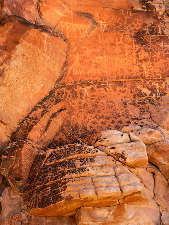
Intricate Fremont People petroglyphs on a high cliff face at Whitney Pocket, challenging understanding of their creation.
Cliffside Chronicles: The Fremont Petroglyphs of Whitney Pocket – Against the canvas of time: The enigmatic petroglyphs of the Fremont People, etched high up on the cliff faces of Whitney Pocket, invite wonder at their ancient origins and the stories they hold.

When we left last week’s adventure, I had found my way back to the main trail. So, with the panic behind us for the moment, I could bide my time and closely examine the surrounding formations for exciting shots. Lest we forget, I was in the process of hunting down the ‘easy to find’ Petroglyphs.

With each step, the downhill trail heading toward Lake Mead took me back hundreds of thousands of years in geologic time. As shown in last week’s photos, we journeyed from the white Navajo Sandstone era to its contact with the iron-rich red Entrada Sandstone – another silica formation having more iron-oxide (rust) content.

As the trail continued, I was surrounded by red sandstone outcrops covered in the same streaked varnish pervasive in the Lake Powell area. This was a good sign because the black streaking was a common medium for Pueblo Tribes to carve images into. I had been focusing my search at eye level because that’s the height I expected to see the wall art. But, after rounding a bend, I had to step back because I finally found my prize.

There I was, neck craned, eyes skyward, when I finally spotted the petroglyphs. I half expected a Fremont elevator to whoosh down and offer me a ride up for a closer look. Alas, no such luck—I had to settle for the zoom on my camera. With one mystery solved, another popped up. How in the world did these people scratch those images into the rock? Did they build scaffolds, dangle from ropes, or stand on each other’s shoulders? Maybe they were aliens and had invented the anti-gravity hover-walker I longed for. Who knows?

The Fremont and Ancestral Puebloan (often known as Anasazi) Peoples were two distinct cultures that flourished in the American Southwest, leaving behind a rich legacy of rock art that continues to intrigue us today.

The Fremont People, inhabiting parts of modern-day Utah, Colorado, Idaho, and Nevada from roughly 300 to 1300 AD, are noted for their distinctive rock art. Fremont petroglyphs often depict trapezoidal human figures adorned with elaborate decorations, such as headdresses, earrings, and necklaces. These figures are sometimes accompanied by animals, hunting scenes, and abstract symbols. Their rock art, etched in cliff walls and boulders, speaks to a culture deeply connected to its natural environment and spiritual beliefs.

In contrast, the Ancestral Puebloans (Anasazi), primarily located in the Four Corners region (where Utah, Colorado, Arizona, and New Mexico meet), thrived from approximately the 12th century BCE to the 16th century AD. Their petroglyphs and pictographs differ from those of the Fremont. Ancestral Puebloan art frequently features geometric shapes, spirals, bighorn sheep, and handprints with a more abstract quality. Their artwork often reflects cosmological concepts, clan symbols, and records of celestial events.

Both cultures’ art provides valuable insights into their lives, beliefs, and interactions with the landscape. At the same time, Fremont’s art tends to be more symbolic and detailed in depicting figures; the Ancestral Puebloans lean towards the figurative and abstract. These differences highlight the diversity of expression in ancient rock art and illustrate the unique ways each culture related to its surroundings and spiritual life.

The struggle in photographing relics of ancient civilizations is finding them—and finding them undamaged. When you’re standing in front of them, the best that you can do is to frame them in a logical composition. What do you include or leave out of the frame? At this point, creativity goes out the window, and you become a record keeper; your work is indistinguishable from that of a geologist or archaeologist. That’s the mental process that I had when I snapped Cliffside Chronicles. As I aimed the camera, it was thinking, “Hold the camera straight, get as much artwork in as possible, and frame the image tight.” The rock art is impressive enough, and I don’t presume to think I can improve the artists’ work. These shots are my way of collecting these precious works of art and preserving a record of their existence should they be destroyed by vandals.

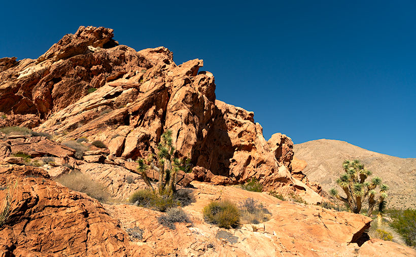
Red oxidized Entrada Sandstone formations at Whitney Pockets, illustrating the geological upthrust in the Mojave Desert landscape.
Red Rocks Rising: Whitney Pockets’ Monumental Sandstone – Nature’s upheaval captured in stone: The vibrant red layers of Entrada Sandstone at Whitney Pockets stand testament to the dramatic upthrusts that have sculpted this desert spectacle.

I hope you enjoyed our hike out to the petroglyphs. If your curiosity has bettered you, there are always larger versions of Cliffside Chronicles for you to examine on my website < Jim’s Website> and the Fine Art America page <FAA Link>. We encourage you to return next week when we look at a geological mystery I found.

Till next time, keep your spirits high and your humor dry.
jw

Techniques: The Magic of Polarizing Filters

Sometime in the last century, when I was a lad still wet behind the ears (what does that actually mean?), I bought a polarizing filter for my first camera. I was less than impressed when I used it in the Los Angeles suburbs. It didn’t seem to do much in the smoggy, hazy atmosphere along the coast. But on a trip to Lake Mead—where my dad kept his boat—boy, howdy, that thing did miracles. That’s the exact general location that we’re featuring in this month’s project, and there is something about the glare of the Mohave Desert that makes one of these filters a must in your camera bag.

A polarizing filter is essential in the bright landscape of Gold Butte, where the white Navajo sandstone reflects the sun’s glare. This tool helps mitigate the glare, allowing the camera to capture the vivid hues and intricate details often masked by the harsh light. By filtering polarized light, the polarizer enhances the natural color saturation of the rocks and the sky, bringing out a richness that the naked eye might miss.

Using a polarizing filter requires a bit of finesse, as it’s most effective when the sun is at a 60-degree angle to the lens. It can darken the blue sky to a dramatic effect and increase the contrast between the sky and clouds, giving your images a more dynamic range. However, be mindful of exposure adjustments since a polarizer reduces the light entering your lens, often necessitating a slower shutter speed or wider aperture. With practice, a polarizing filter will cut through glare and transform your landscapes into deeply textured, color-rich images.

Don’t let the desert’s glare wash out the nuances of its beauty; make sure a quality polarizing filter is part of your photography kit. Remember, like any lens, the quality of a polarizer matters – a cheap one may distort your image and alter true colors. However, consider that polarizers absorb light; they’re fantastic under the brilliant sun but can leave your photos underexposed in dimmer conditions. A polarizing filter in low light is like sunglasses at midnight – you will miss the stars and probably trip over the campfire. It is best to keep it tucked away when the sun takes its siesta.

Sculpted by Time: Whitney Pocket’s Sandstone Wonders Picture of the Week - Mesquite, Nevada

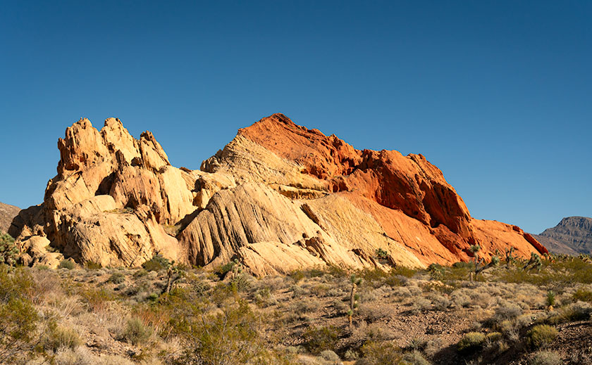
White sandstone rock formation at Whitney Pocket, similar to Zion National Park, in the Gold Butte area of Nevada.
Sculpted by Time: Whitney Pocket’s Sandstone Wonders – Amidst the rugged beauty of Whitney Pocket, this layered sandstone formation stands as a silent witness to the artful touch of natural forces, its contours and colors a desert echo of the famed cliffs of Zion.

Before we even packed the Turd for our Nevada trip, I studied all of the Whitney Pocket YouTube videos I could find like they were a final exam. Packing the Turd for the trip felt a bit like preparing a stubborn mule for a mountain trek—full of hope but expecting surprises. When the morning of our exciting adventure finally came, I had my checklist ready. After a hardy breakfast at Peggy Sue’s Diner, we topped off the gas tank and checked the tires. Part of these exercises was taking precautions and waiting for the visitor’s center to open so that we could buy maps and get free first-hand advice.

The people who answered our questions and the Friends of Gold Butte group volunteers were constructive. With a lack of park rangers, they’ve stepped in to fill that role. After reassurance that my SUV would be capable of the drive, the guide offered one last bit of advice. “Be sure to tell someone where you’re going and when you expect to be back. No cell phone coverage exists, and you could be alone out there.” Anne and I glanced at each other, wondering who we could call—we were alone in Mesquite and didn’t know anyone in town. We decided to call her sister—Jane— in North Carolina and panic her, “If you don’t hear from us by 6:00 pm, call the police.”

After the long drive on the awful road I complained about last week, we made it to the end of the pavement—Whitney Pocket. When I first got out of the truck, I felt disappointed. With our backs to Virgin Peak, we scanned the southern horizon, which went on forever in the clear, dry Mohave Desert air. Except for a few lumps of sandstone close by, there was just a sea of yucca and creosote running endlessly downhill to a thin line of blue, which we identified as Lake Mead. Where were all the majestic sandstone formations in the videos I watched?

We were here, and I would make the best of it. Our map showed a petroglyph site three miles down a side road that we passed, so I drove a quarter mile back and started down what I jokingly call a road. The road was passable, but only if I kept the speed under ten mph. The Turd’s front sub-chassis sounded like it was about to fall off as we dodged the football-sized pavement rocks. In comparison, the entrance road was a freshly paved Interstate.

As promised, there was a parking area with a kiosk and pictures at the three-mile mark. Go to the right and see the Falling Man petroglyph, but there would be a large panel of petroglyphs if I went in the other direction. The guide told us that the Falling Man was a longer hike and tricky to find, so I set off toward the easy shot while Anne and her Kindel kept each other company.

After a half hour of scouring the rocks for rock art, I realized I had missed the trail, was lost, and needed to find my way back to the truck. The trail had been pronounced, so I don’t know how I messed up. I started the hike back using my old tried and true method: ” This looks familiar.” I noticed the rock colors and layers as I searched for the trail. They’re more subtle and muted than you find in Bryce or Zion—almost a pastel quality. Then, I crossed over the surface stone patch and found my trail. I stopped, looked around, and discovered that the trail zigged right while I went left. Ah, the old let’s lose the geezer on the hardscrabble trick.

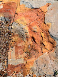
Water or ice erosion exposing red sandstone layers beneath the surface in Whitney Pocket, Gold Butte area.
The Art of Erosion: Exposing Whitney Pocket’s Hidden Hues – Nature’s artistry on display: The intricate dance of erosion carves through time, uncovering the fiery red heart of sandstone beneath the desert’s sunlit canvas.

Now that I was un-lost, I started taking pictures of the stones and capturing the muted colors washed out with the early afternoon sun. My trip back to Anne and the truck was more deliberate as I spent more time shooting and exploring along the way. As we drove away on the rock road, I turned to Anne and said, “I don’t think we should risk running the Turd down these roads until we get new shoes for him.” Anne’s ‘Oh, thank God’ was laced with so much relief that I suspected she might start a Thanksgiving parade there.

While the grand formations played hide and seek with our expectations, the true majesty of Whitney Pocket revealed itself in a serendipitous encounter. This week’s photo—Sculpted by Time—captures a lone formation made from the same limestone that capped Virgin Peak (last week’s shot), one that almost seemed to beckon for attention amidst the vast desert. Its white, streaked face looks unremarkable at first, but if you look closely at the lower-right corner of the image, you’ll see a joint (not that kind, you stoners). This is where a layer of the Navajo Sandstone is popping its head from the ground. These are the same petrified dunes seen in Zion National Park, and we showed you in Utah’s Snow Canyon State Park last year. This shot was a dance of light and texture, a moment where time stood still, and the story of the earth was told in a single frame of layered rock.

Here is evidence of rising ancient seas and covering the dunes up. Over eons, the skeletons of shellfish collected on the seabed and covered the dunes with a layer of their own. I think that’s cool, not to mention that I like the natural window in the upper center, too.

Next week, we’ll return to Whitney Pocket, but our focus will shift to the ‘Dance of Light and Shadow’ this time. We’ll explore how the changing sunlight angles transform the sandstone from mere rocks into a canvas of nature’s art. Expect tales of how the sun brings out different personalities in the stones. If you’d like to examine the rock layering closer, you can stop by my Web Page < Jim’s Page> or my post on Fine Art America <FAA Link>.

Till then, keep your spirits high and your humor dry.
jw

Uplifted Beauty: Virgin Mountain’s Desert Vista Picture of the week - Mesquite, Nevada

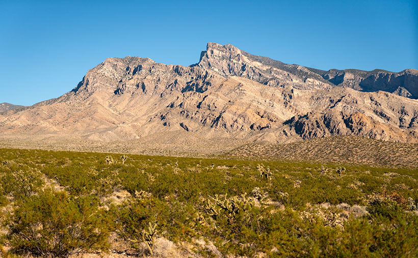
Virgin Peak’s profile with Mohave Desert vegetation on talus slope in Gold Butte National Monument, Nevada.
Uplifted Beauty: Virgin Peak’s Desert Vista – This featured image captures the majestic Virgin Mountain from the road leading into Gold Butte National Monument in Nevada. The rugged profile of the uplifted mountain is beautifully contrasted with the Mohave Desert vegetation adorning its slopes. Virgin Peak is a quintessential symbol of the Basin and Range topography, epitomizing the rugged and varied landscape that is so characteristic of Nevada.

My process for choosing new shooting locations involves endless map searching and YouTube videos. When I find a new spot on the map, I watch videos of the area to determine if I can get there—and, more importantly, safely return. A few years ago, I considered an excursion into the relatively new Grand Canyon-Parashant National Monument in the northwest corner of our state. Few photographers have been there, so it should be ripe for the picking. Alas, I determined that my SUV wasn’t ready for prime time.

However, I did find a spot along the way that looked promising and on a paved road. Whitney Pockets is located in our newest National Monument—Gold Butte. The only access to it is from Mesquite, Nevada. Over the past couple of years, I’ve unsuccessfully tried to get it on our schedule. Gold Butte is a remote part of Nevada wedged between the Overton Arm of Lake Mead and Arizona. Apart from the entrance, it has no paved roads, campsites, gas stations, restaurants, or cell phone coverage. The monument’s target audience is four-wheelers seeking wilderness solitude without hiking—my kind of people.

In October, Anne and I finally made our first trip into Gold Butte and shot the Whitney Pocket area at the pavement’s end. It’s our December photo project, and I think it’s an excellent way to end the year.

Whitney Pocket was so compelling for us to visit because it’s in the pristine Mohave Desert with outcrops of the same sandstone foundations in Zion National Park and Southern Utah. You can see the monument from your Mesquite hotel room, but to visit, you must drive around the west side of the 8,075′ Virgin Peak—the mountain you see south of the river. The drive from the bridge crossing the Virgin River is an hour or 22 miles on bad pavement. Never before have I had to air-down the tires for tarmac. Trust me, if you try going faster, your kidneys will bleed, and you’ll constantly be stopping to pick up falling parts. The road was mysteriously constructed in the 30’s and hasn’t been maintained since. I’m sure some of those pot-holes are as old as the road.

Whitney Pocket has broad-level areas that are good for trailer parking. There are a couple of port-a-potties in the space, but nothing else. Just you, the rocks, the Mohave Desert, and stars—there are so many stars, even with the Las Vegas light pollution on the western horizon. You’re out of luck if you want a map or something from the gift shop. They’re back in town at the visitor’s center.

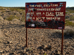
Humorous warning sign in Gold Butte, Nevada, about flat tires and hot radiators, against a desert backdrop.
Gold Butte’s Quirky Caution: Desert Trials and Travails -Keith Nay erected this sign in the late 60s. He was a former rancher in the area. Tired of unprepared tourists getting lost or stuck, Nay put this sign on a friend’s private property along Gold Butte Road to deter people from venturing further into the wilds of Gold Butte. The sign reads, “The most exciting thing I have seen out here was a flat tire and a hot radiator.” A second sign that used to be on the back read, “Wasted time? What a ‘shame’. In loving memory of Keith Nay.”​​​

If you’re into human history, this isn’t the place to be. It’s so remote the Army used it to test the worthiness of its desert vehicles. None other than General Dwight D. Eisenhower led an expedition across this part of the Mohave desert between the World Wars. The remains of his tracks are one of the side roads you pass along the way to Whitney Pocket.

A few petroglyph panels are found inside the monument that originated with the Fremont people of central Utah. The most famous one is the Falling Man panel because it’s an uncommon depiction. Don’t look for them on the maps, but several people have directions online. The Bureau of Land Management would prefer them to be undamaged, so the fewer people visiting them, the safer they are.

An old mine town, appropriately called Gold Butte, is at the south end of the monument. Oddly enough, it got its name from the nearby butte of the same name. They say that only the foundations are left. Besides that boom town, few souls have tried prospecting or cattle ranching here. Among them, a legend grew around Howard Hughes, the enigmatic tycoon rumored to have orchestrated the construction of the road into the region—allegedly overnight—in the 1930s.

The designation of Gold Butte as a National Monument was the culmination of a two-year campaign led by local conservation groups, Nevada and Clark County lawmakers, and the Moapa Band of Paiute Indians. This concerted effort resulted in President Obama designating the area as a national monument under the Antiquities Act on December 28, 2016. The designation, which occurred on the same day as the designation of Bears Ears National Monument, was also strongly supported by U.S. Representative Dina Titus and outgoing U.S. Senator Harry Reid, as well as the Las Vegas Paiute Tribe

As I said, this was our first venture into Gold Butte, and I can’t wait to return. But since access to the rest of the monument is over rock-covered roads and through dry washes, it will have to wait until I buy proper off-road tires for the Turd. Maybe this spring, after the winter rains bring out the spring wildflowers. Consider joining us if you’re into solitude and grit in your teeth.

I hope you enjoyed our introduction to Gold Butte and Whitney Pocket. Be sure to stop by each Sunday this month (after you get home from your Christmas shopping). I have more pictures to show and stories to tell. If you’d like to see a larger version of Virgin Peak (I almost called it Madonna—you know, ♪ like a Virgin ♬—but Queen Anne thought that was silly), you can see it on my website < Jim’s Web Page> or its FAA page <FAA Link>.

Till next time, keep your spirits high and your humor dry.
Jw