Black Butte Picture of the Week

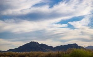
The Vulture Mountains are a twenty-nine-mile long collection of volcanic hills south of Wickenburg. The Hassayampa River runs along the range’s eastern boundary and the mountains taper off to the west. From our Congress home, two peaks rise out of the low mounds on our southern horizon: Vulture Peak’s rounded knob is to the left and the sloping top of Black Butte is on the right. Reminding me of a doorstop or a fallen cake, Black Butte is the subject of this week’s photo.

Black Butte
Black Butte – With its distinctive sloping top, Black Butte marks the western boundary of the Vulture Mountain Range.

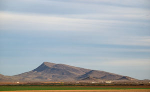
The slanting top of Black Butte first caught my attention while I was still working. I drove the forty mile trip from Wintersburg to Congress on the Vulture Mine Road and the butte marked the place where the road turns north. I thought that its shape was the kind of thing you’d see in old western movie backgrounds. I knew that I would use it as a subject some time. A couple of weeks ago while I was shooting in Aguila, there it was waiting for me bathed in late afternoon light.

You can see the larger version on my Website by clicking Here. I hope you enjoy viewing it and I’d love to hear your comments below.

Until next time — jw

Eagle Eye Picture of the Week

We’re still hanging in Aguila for the new Photo of the Week. Although I drove twenty-five miles to the little town because I had wanted to shoot a specific sign, I then poked around town to see what else I could photograph, and I found the number one reason—if there is such a thing—to visit Aguila. Here’s my shot of the natural window in the hills south of town formed by eagle-head-shaped rocks. Aguila is the Spanish word for eagle; hence, you have the town’s name source.

Eagle Eye Window
Eagle Eye Window – Rocks form this window in the shape of an eagle’s head and is in the hills south of Aguila, Arizona.

I’m sure there’s a way to climb up to the window because I’ve seen people there. I didn’t take the time to find a way on this trip, but I saw on Google Maps that there was a trail from the cemetery south of town. As I said last week, there is a good view from the window along US Highway 60 by the working fields of Centennial Ranches. Even a moderate telephoto lens will bring the Eagle Eye closer.

I followed dirt roads between the fields to get closer for this shot. They had street signs, so I assumed the roads were public. It was late in the afternoon when I snapped this, and the beautiful streaky clouds were beginning to get color. I should have waited for sunset, but I wanted to get to another scene that I saw along the trip (which was a bust). You can see the larger version on my Website – Here. I hope you enjoy viewing it. Please let me know what you think by leaving a comment below.

Till next time — jw